New DC Circulator route serving National Mall reminds us that we are neglecting connections from west to east and fail to adequately connect Georgetown to the National Mall
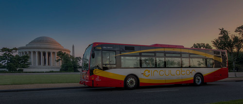
Photo from the DC Circulator of a bus stopped at the Jefferson Memorial. The service launches this Sunday.
A few weeks ago, the Georgetown Business Improvement District showcased a couple of pop-up urban design and service initiatives.
One was demonstrating what M Street could look like if the parking lanes were given over to wider sidewalks. (I would have done a sample section showing an actual change but that's me.)

I talked with the staff member at the table and we had a good conversation. And it made me realize that I haven't adequately thought through thinking about visitor services at two scales: the city as a whole and within key subdistricts like Georgetown, Dupont Circle, and Capitol Hill.
Providing sustainable transportation connections from the Georgetown to the National Mall is neglected. One person came up to the table during the time, and wanted to get from there to the Lincoln Memorial.
The options suggested were all "inefficient," sending her to Union Station to get to there. She wasn't interested in bike share, and there aren't transit options. So she ended up taking a cab.
 I realized that my proposal for a heritage streetcar and visitors center system for the National Mall is also focused on moving people east to west, from Union Station mostly.
-- A National Mall-focused heritage (replica) streetcar service to serve visitors is way bigger idea than a parking garage under the Mall
It fails to provide connections from west to east, specifically from Georgetown.
Plus I proposed that the service end at the Kennedy Center.
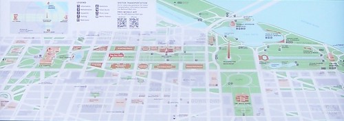
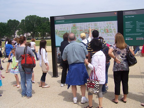
That's because we're focused on "the National Mall" rather than the monuments, parks, and waterfront areas more generally and as a complete whole. That's shown in this map of the National Mall, captured from a National Mall Wayfinding sign.
But the National Park Service manages the entire system as a unit, including sites across the Potomac River in Arlington County, Virginia. And an integrated visitor transportation and service system needs to treat this as one unit as well.
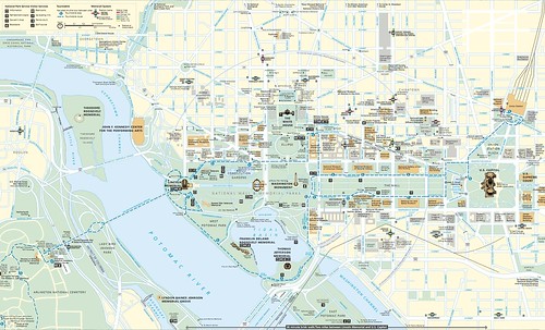
Map, The National Mall and Smithsonian Museums, National Park Service.
Plus, given the fact that Georgetown is one of the city's primary tourist destinations outside of monuments and museums, not extending or mirroring transit connections from Georgetown to the monuments on the National Mall is a serious omission.
But it has been an omission all along, as the DC-centric streetcar system didn't provide many connections across the city's borders, mostly stopping at the edge.
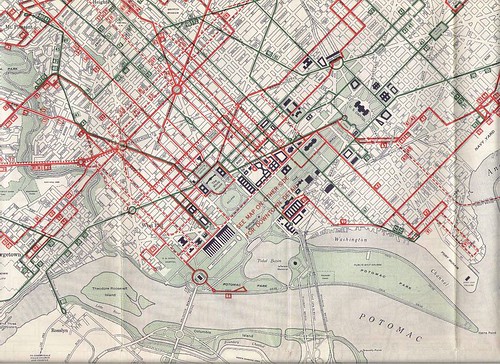
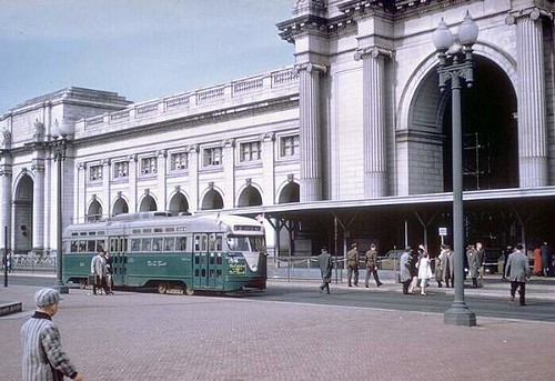
DC Streetcar and bus map, 1955
The old streetcar system provided service to Georgetown on many routes. The 10 line from Deanwood via H Street to Rosslyn operated until 1949. The 20 line, from Union Station to Glen Echo served Georgetown afterwards, as did other lines.
The new DC Circulator route for the National Mall, which will start up on Sunday, makes the same omission that I did. It provides service east to west, but the service terminates at Lincoln Memorial.
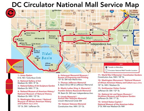
I would argue that the service should loop to Georgetown as well.
Were there a permanent visitor center in Georgetown, that could be the termination point.

It would be complicated to go across the Key Bridge, because of the steepness of the grade between the Georgetown waterfront and M Street and the limited street space options therein.
Finally a visitor center for Georgetown should be a key element of the overall program proposed in my heritage streetcar+visitor services concept.

Labels: car culture and automobility, cultural heritage/tourism, museums, streetcars, transit, transportation planning, urban design/placemaking, visitor services
posted by Richard Layman @ 11:24 AM&Permanent Link
![]()
![]()


16 Comments:
In the GGW live chat with the new DDOT director, it sounded as if the U street circulator extension was dead.
I'm not sure Georgetown needs a visitor center. The K st circulator line doesn't work great as a connection to the metro anymore.
When I did ride the Dupont circulator (which does work well as a metro access line) i'd say a good quarter of the riders were looking for the foggy bottom metro.*
I'd have no problem removing parking from M st, but you need those lanes for car travel. The backups on M st can be bad on weekends and non-rush hours as a result. Also they are extensively used for deliveries.
* That line worked well until they narrowed L st to put in a bike lane before New Hampshire.
I think Georgetown, Dupont Circle maybe, and Capitol Hill "need" visitor centers, combined with major centers at Union Station and a Yellow Line Metrorail Station, complemented by the federal ones (White House, Capitol, Smithsonian), which because of federal laws, refuse to distribute local information.
I'll be writing another visitors center piece soon, but you're familiar enough with the points, based on this and other comment streams.
2. wrt a U St. Circulator, while I didn't think it made sense before, I can see one operating from Dupont Circle up to Florida Ave. to U St. to 7th St.
In any case, it's worth testing.
The problem is like you say about M St. traffic. 7th St. traffic from sometimes Rhode Island but definitely from S-ish to around the McDonalds on Georgia Ave. can be quite bad.
Sending it to the 7th St. metro T Srt. entrance wouldn't work for speed. But it could use the area of 7th, V, and 9th as the turnaround, but that wouldn't provide the same logical turnaround as the Metro Station.
Ideally, yes, it'd be better to run it from Dupont Circle with service to U St. and end point at the 7th and T Metrorail station.
BUT if HU would be willing to let DDOT put a high quality (like Metro in Minneapolis, the new BRT stations in Mississauga, even the Clarendon bus station, etc.) "station" set back off the street there on Georgia, it would work, sort of. Maybe it's just worth biting the bullet, paying for a couple more buses, and terminating it at the 7th and T Metrorail station.
I would just run it Thursday through Sunday as a start.
If we had better transportation + visitor planning and coordination and management, it could be funded in part through tourism tax revenue streams.
But how do you make it cool, when "hipsters" think it's better to ride Uber and not mix with the masses. And therefore, as you have frequently pointed out, this leads to massive congestion of all the black cars on Friday and Saturday nights.
RE: U st, while this is a route that I would probably use -- (U st to M/24) it never made sense as a unified route. (Rosslyn to U st)
You'd get tied up in Dupont circle traffic as well. I never thought about the terminal problem on U.
there is enough vacant space at Georgetown harbor to do a visitor center. Or, as you said, the former mall.
The other bad part is the new circulator buses won't be the Van Hool, and you'll probably going to lose those windows.
didn't realize that was the preferred, end point at Foggy Bottom. traffic would be terrible, but it is also a logical beginning point too.
i don't know why they didn't do Van Hool, although I have an idea. Probably New Flyer didn't like the ex. of Van Hool buses vis a vis WMATA, plus in DC in general where they get marketed in a way to other systems as elected and appointed officials travel to and from Washington, so New Flyer offered a great rate.
Or it was just easier administratively to glom onto the WMATA acquisition process, rather than enter into a separate process and agreement that DDOT would have to do. As you know, that piece of contracting and procurement ends up being complicated and expensive and time consuming.
e.g., similarly, while dc gets all the acclaim about bike share, DC actually jumped onto the contract that Arlington made with Bixi (this is an element of MWCOG membership, procurement terms sharing), which significantly speeded up the process for DC, when SmartBike devolved into a dead end because the contract never called for expansion, only testing, and Clear Channel had no interest in expansion.
I think the unique Van Hool design is a key element of the branding success and positive attitudes toward the Circulator service.
If it's just another New Flyer Bus, even with different livery, I do think that the positivity in the ratings is likely to decline.
no, that is my end point -- the proposal was to run it to Rosslyn. Huge number of traffic choke points: Key bridge, L st, Dupont (Both north and south), getting on to U st, turnaround.
I agree with you on the Van hool design. There wanted hybrid buses, although I suspect, as you allude to, you design the RFP to get certain results.
At least they finally fixed the paint job so the buses don't all look like they go to Union Station.
The New Flyer buses were really cool 10-15 years ago or so when the design first came out, used in bus rapid transit.
It's old now. The current version is an update of a model first released in 2005.
https://en.wikipedia.org/wiki/New_Flyer#/media/File:HealthLine_1.jpg
Transit systems traditionally haven't thought about remaining forward in design, especially with buses.
I guess like the automakers, maybe it's better to buy fewer buses but more frequently, just from a design standpoint. But it is more expensive.
One of the reasons I push the idea of double deck designs is that this type of design is considered very positively because of the London Routemaster bus.
However, we don't really see evaluations of their use in places in North Am. such as Ottawa and Snohomish County, Washington (Community Transit), where they are used in high quantity in service that is more like regular service rather than longer distance commuter bus service (e.g., GO Transit in Greater Toronto).
It would be interesting to do. I am way way way behind in writing, so I am not likely to get around querying some of those systems, but I will put it on the list...
2. The Designline buses used in Baltimore seem to appear to be forward looking as well, and are made in the US. Maybe... the company was in bankruptcy. DK if they ever got out.
http://www.mdcleanenergy.org/sites/default/files/upload/image/Circulator%201.jpg
to reiterate, I agree with you that routing between Rosslyn and Foggy Bottom, without a dedicated transitway, will be subject to massive delays. And similar problems could exist from Foggy Bottom to Dupont Circle. You could route it via New Hampshire Ave. and avoid traffic, but it might be less useful to users. DK.
I'd try it from Dupont Circle to 7th and T, and worry about extending it later.
"If we had better transportation + visitor planning and coordination and management, it could be funded in part through tourism tax revenue streams."
Why not put together a proposal and budget and present it to the Bowser Administration?
-EE
again sorry to hijack the thread.
I saw one of the new circulator buses on the K st route by whole foods last night.
Found this on the web:
https://mlpforums.com/blog/677/entry-16171-for-the-transit-fans-in-depth-review-new-flyer-xcelsior-xde/
I don't really have particularly well-greased access to people in the administration.
MB is a good example of politics not being about a "continuous seminar in creating better and best practice and innovation."
And she I am sure sees me as a pain in the ass, as she doesn't have a particularly nuanced interpretation of the difference between "critical analysis" and what many politicians end up seeing as "personal criticism."
What I am trying to do, and so far have failed miserably, is move to the point of creating "position papers" like a think tank. (Ideally, I could try to line up funding to create a new "Center for Washington Area Studies" to do this kind of stuff. It's something I talked with Bell Clement about a long time ago, but then she went on to get her PhD. An "action-research" think tank and civic capacity building center, not unlike a combination of Municipal Arts Society, Center for an Urban Future, Citizens Union Foundation, and Center for Urban Pedagogy in NYC + some other elements, including the decades defunct Citizens Involvement Training Project at UMASS.)
So the two papers I haven't done so far include the "marshall plan for wards 7 and 8" and rearticulating equity planning and (2) rearticulating the central library as the city's foremost civic-knowledge-cultural asset and anchor.
Dealing with the tourism tax revenue stream is something that I did put out amongst other elements in this "paper" that I wrote in 2006 for Bell Clement for use at an HSW board meeting, back when she was interim director.
http://urbanplacesandspaces.blogspot.com/2007/01/cultural-resources-planning-in-dc-in.html
It's worth taking another pass at it.
Similarly, the basic piece on the visitor transportation and tourism support system centered around the Mall is laid out in the cited previous entry, but deserves a much fuller treatment.
I intend to start taking some Adobe Illustrator and InDesign classes at MLK to learn some of the basics of graphic design and better page layout production to be able to illustrate some of these concepts graphically and to go beyond Microsoft Word (which is not great for efficiently merging graphics and text).
And there is the piece I want to do on Union Station, WMATA, and regional railroad commuter services.
.. and a fuller explication of the Signature Streets concept (which ends up as the basis of the equity planning model too, because it all comes down to providing civic assets and programming, just in a systematic tightly integrated and innovative fashion).
Richard,
This blog is a testament to the fact that writing, thinking, planning, postulating, explicating, arguing, etc. are like breathing to you.
Personal experience with you over 10+ years has left me with the impression that editing, follow-through, financial matters (funding/financing), politics and the like are not.
If you are committed to your ideas and want to see them fulfilled, I would ditch the above litany of excuses to avoid dealing with the very difficult parts of the process.
-EE
... I called it a lack of focus. Jennifer Steingasser kindly refers to it as "a breadth of interests."
But it is hard for me to deal with politicos, because they aren't really focused on "doing a lot better" as much as doing.
It's hard for me to suck it up.
p.s. a good example is the Circulator. People know my position, that for the most part, the routes outside of Downtown don't make economic or planning sense. They do make "political" sense, which is why they continue to expand. But politicos don't stand up and say "these are a waste of scarce economic resources" instead they force the expansion.
that being said, I do believe in provision of intra-neighborhood bus services, just not the way the Circulator is done.
Memphis trolley system is another model.
https://www.commercialappeal.com/story/news/local/2018/04/27/what-know-main-street-trolley-memphis/548245002/
4/29/2018
Post a Comment
<< Home