Comments on the Central Avenue Connector Trail concept (Prince George's County, Maryland)

I think the trail concept is quite exciting. It will be highly visible and because of its visibility, will be a best practice infrastructure improvement at two levels, in the DC area, but also at the scale of the State of Maryland, and it likely will encourage other communities to take on similar projects.
The planning process is being spurred on by the county planning department, not the transportation department.

Most of the attendees at the meeting were African-American and older. And it was a meeting on bike and trail planning.
IT WAS AN INCREDIBLY CIVIL MEETING. AND PRODUCTIVE.
Considering all of the various cacophonous planning meetings I've attended in DC or ones I haven't ("Can some big DC churches fight off a bike lane? They are bringing large crowds to try.," Washington Post), I was surprised at the time and nonplussed about why civic discourse in DC tends to be such a flawed process.

====
1. The Connector Trail proposal, by linking four Metrorail stations, would be a significant access improvement and an example of national best practice of shared use paths being constructed in association with rail transit.
Because it will be so prominent and visible, you may also want to co-brand it as the Prince George's County Blue Line Transit Trail as a sub-head.
 And because it will be so prominent and visible it will market improved biking and walking infrastructure to other areas of the county. So it is very important to get it right.
 Design of great signage and a logo and brand is key.
2. The approach on having the trail be a connector (transit, neighborhoods, commercial districts, schools, parks, and other institutions) is sound and doesn't require comment.
However, while the Potomac Yard Trail was shown as an example in the Toole presentation, another example that comes to mind includes the S-Line Greenway trail parallels the streetcar line serving Sugar House in Salt Lake City.
It's a multi-modal and recreation corridor parallel to the streetcar line, with "public plazas, art, walking paths, a bocce court and a new segment of Parley’s Trail" ("Walk, ride, play: S-Line Greenway opens in Salt Lake City," Salt Lake Tribune).
If necessary, you should consider organizing some field trips for stakeholders to show by example that these types of infrastructure work.
Plus, PGC already has a great example in the section of the Northwest Branch Trail from Rhode Island Ave. to Queens Chapel Road and on to West Hyattsville Station.
It only gets to one Metrorail station, but the way it provides protected access to various park and civic assets, and to shopping options, including grocery stores, is awesome. The Cynwyd Trail in Lower Merion Township, connecting to the Manayunk neighborhood in Philadelphia, is another similar example.
In the region, the Baltimore and Annapolis Trail is a good example of how to encourage integration with businesses and support local economic activities. Rails to Trails did a good story on this and the trail about 6 years ago. Over time, businesses are adding back entrances to serve trail users. (This is starting to happen on the Indianapolis Cultural Trail too.)
 Depending on the household, abutting properties along trails in Catonsville may have fences, fences with gates, or no fence.
In response to concerns expressed by residents in terms of residences abutting the trail, in Catonsville, the main "trolley trail" was created as a response to the nuisance uses of an abandoned streetcar right of way.
The trail immediately abuts houses, and with experience people don't have problems with it.
Positive use ends up outweighing negative use--whereas before, the unused right of way was used for illicit activity, illegal dumping, etc.
3. Initiatives to increase biking take up by African-Americans. One of the people at our table made the point that African-Americans "don't bike," even though she herself is a recreational cyclist.
We had a spirited discussion on how to do programming, outreach and engagement activities to address this and increase biking and walking and use of the trail. There are many things that can be done to do this, including park, school, Metro station, and neighborhood based programs, rides, etc.
A whole year of special promotion activities should be launched to build use of the trail, rather than to merely expect use to trickle up.
The Community Cycling Center of Portland (Oregon) has a particularly good initiative directed to increasing bike as transportation take up by low income and African-American riders.
The Major Taylor Bike Club program (especially in Seattle, see "Seattle bicycling clubs for disadvantaged kids get rolling" and "Young people find cycling gets the wheels turning," Seattle Times) and Neighborhood Bike Works and the Cadence Cycling Foundation ("Cycling comes to the inner city," Philadelphia Inquirer) in Philadelphia and Recycle-A-Bicycle in New York City are other examples. As is the Black Women Bike initiative in DC.
4. Although implementation of systematic approaches to increasing the take up of biking as transportation amongst all demographics is the best way to address demographic categories across the board.
For example, working with senior centers and retirement communities could increase biking activity by seniors. The Ateaze Senior Center in Baltimore County has a serious biking club. Retirees in the Blue Bell community in Greater Philadelphia created the "Old Spokes" club which holds rides every couple weeks in area parks ("Freewheelers The Old Spokes, members of a bicycling club, venture from their retirement community to cruise the region's byways," Philadelphia Inquirer).
Disabled access was mentioned in the meeting. The Metropolitan Branch Trail is used by some programs to provide walking access to people with serious disabilities. This allows participants the ability to walk, very slowly if necessary, without having to worry about motor vehicles.
Some jurisdictions have special programs which promote bicycle use by the disabled as well. See "Two-wheeled self-confidence: Special bikes for special kids," Philadelphia Inquirer.
Kidical Mass is a ground-up community program that encourages biking by families.

Open Streets programs are another way to promote biking and walking. Launched in Bogota, Colombia, and held every Sunday, such events are now offered across North America, where the street is closed to motor vehicle traffic, to encourage walking and biking and related activities.
In Greater Los Angeles, the LACMTA is the major sponsor of such programs, which move around the region, and are held in the fall and spring. Many organizations hold parallel events in association.
Recently, BikeMaryland was one of the sponsors of an Open Streets event in Columbia in Howard County.
-- "Event to open Little Patuxent to bikes and pedestrians," Baltimore Sun
-- Horizons Foundation Open Streets program, Howard County
-- Open Streets Guidebook
 5. Is it possible to encourage the development of a cycle shop-cafe at a highly visible location on the trail, comparable to the Freewheel Bike Center on the Midtown Greenway Trail in Minneapolis?
 Separately, I have proposed such shops as combination cycle shop-cafe-bike tourism-sustainable transportation/Commuter Store.
Or developed as a hybrid "recreation" facility that could serve as a primary delivery point for recreation programming promoting walking, biking, and fitness.
This building could also have a "comfort" station, as was suggested by some meeting attendees.
6. Relatedly, bike co-ops and programming activities can be integrated systematically within the schools and recreational facilities already present in the corridor. Mount Rainier has a volunteer bike co-op which could serve as a model for other support activities and programs for other county locations. A similar operation, Phoenix Bikes in Arlington County, for a time had been based in a county park facility.
Given the number of schools and parks in the trail catchment area, such activities could begin now, in advance of the trail's construction.
7. We can't forget running and walking. Note too that running footwear shops also like being close to trails and can be logical partners for trail-related activities, races and running events, etc. A fundraiser run on the North Central Trail (Baltimore County) is a regular activity.
8. The WMATA Bike and Pedestrian Access Study findings for the four blue line stations should be updated in concert with the development of the trail. Besides any changes arising from a review and update, at a minimum station bike parking facilities should be upgraded in association with the new trail. High quality air pumps and bike repair stands should be installed at each station. It could be easier to install air compressor based pumps at the stations, because of access to electricity, as opposed to non-electric pumps.
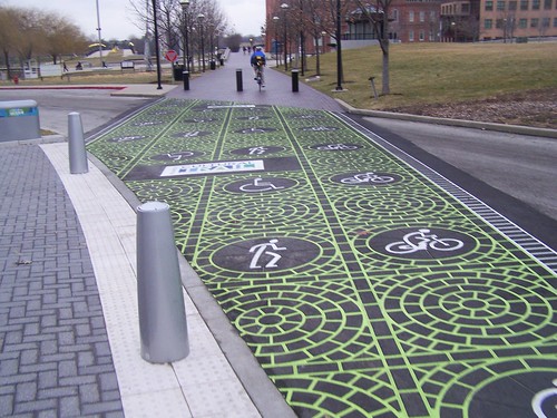
9. Trail width is likely inadequate as shown in the presentations. The narrower the width, the more difficult it is to accommodate people of different skill levels, speeds, and volume. Trail width guidance is inadequate in AASHTO publications. Urban trail widths should be greater than 10 feet wide, based on predictable increases in use over time.
-- Shared Use Path Level of Service Calculator, FHWA
 Flickr photo by lefauxfrog of an trail entrance sign on the Minuteman Bikeway in Arlington, Massachusetts.
 The point I make is that planning is supposed to "design conflict out" rather than engineering it into our infrastructure.
Narrow shared use paths (the Mount Vernon Trail is particularly notorious) in the region demonstrate the need to plan for higher volume use, especially given higher targets in master plans for trips by sustainable means.
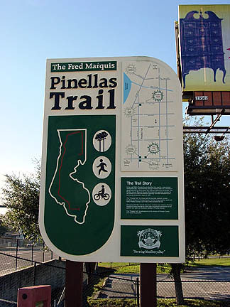
10. Wayfinding signage. Generally, area trails have deficient signage. The Bethesda Trolley Trail is an exception.
But it is possible to develop a signage hierarchy, with gateway and in-trail signage, including maps and information, directional information (why not include bike shops and access to air on such signage) and intra-neighborhood signage directing people to and from trails.
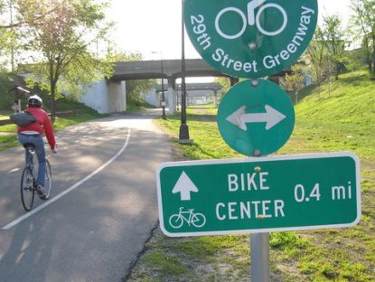
Sign on the Midtown Greenway Trail providing information on the trail-based bike center.
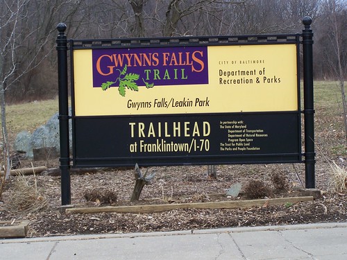
The Gwynn Falls (see photo below) and Jones Falls Trails in Baltimore have great gateway signage. Gwynn Falls Trail also has nice cultural interpretation signage.
The Minuteman Trail in Greater Boston does as well.
Well-designed signage should be developed with an eye towards branding and marketing and promotion of sustainable transportation.
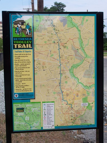
Bethesda Trolley Trail wayfinding sign: map side including trail rules. This signage is unique in the region for showing the basis of a regional network of bikeways as an inset. Austin, Texas also has map signs that are incorporated into their street bike signage system.
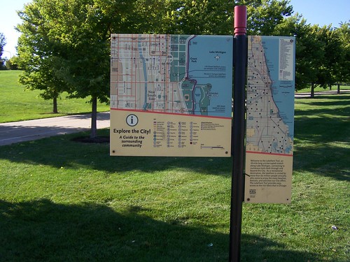
Map-wayfinding sign, Lakefront Trail, Chicago
11. Interpretational signage. This was discussed in the presentation by Toole Design. DC's Cultural Trails walking program, Silver Spring's history trail signage, interpretational signage for the Gwynn Falls Trail, the history signage for the Anacostia Trails Heritage Area, are all good examples.
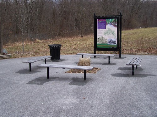
A sitting area with benches and a cultural interpretation sign on the Gwynn Falls Trail, Baltimore.
I would argue that a general interpretational program for transportation history is something that could be developed for this project and applied more generally throughout the county. The Center City District in Philadelphia has such a program, with signage integrated into bus shelters. The Toole presentation did mention this kind of idea, briefly.

Art topped wayfinding signage, Indianapolis Cultural Trail.
12. Public art installations as an element of the trail program was not discussed in the presentations and could be an additional part of the program. MBT has some public art including murals. The S Line is another example. Many trails incorporate murals. The Indianapolis Cultural Trail has installed works by internationally prominent artists.
13. Lighting. The solar-powered lights on the Metropolitan Branch Trail and the walking trail on National Park Service land connecting the Fort Totten Metrorail station to Fort Totten Drive NE in DC have proven to be inadequate at night. Besides adding "sidewalk" and "trail" lighting, might it be possible to light the off-road section on WMATA right of way from WMATA sources?
 This has already been identified as an issue with trails near other stations elsewhere in Prince George's County, such as West Hyattsville Station ("Darkened Part of Park Trail Near Metro to Get Lighting," Washington Post, 2007).
14. Maintenance, especially in the Winter. Besides the general maintenance points made by many, special attention should be given to snow removal.
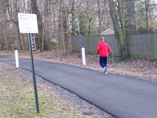
Typically, snow removal policies preference roads at the expense of sidewalks and trails. DC does do snow removal on some of its trails. Montgomery County and Arlington County are beginning to do so. The Mount Vernon Trail, on National Park Service land in Northern Virginia, perhaps the region's most heavily used trail, does not have snow removal, which significantly impinges upon winter commuting.
Minneapolis has particularly good guidance concerning snow removal. Montreal has created a winter bike route system as a sub-set of the primary system, and they have committed to snow removal for the winter route.system.
 15. Security. The failure by DC to adequately plan for security, signage, call boxes, etc., for the Metropolitan Branch Trail, which abuts an industrial area, likely has contributed to flare ups of crime from time to time on that trail.
 PG Parks already has a protocol for signage and call boxes on at least some trails, judging by my experience with the NW Branch Trail. Maybe this needs to be updated and extended while planning for the more transportationally-focused Central Avenue Corridor Trail. Fortunately, with increased use, problems are reduced.
But the off-road section of the trail along the WMATA right of way could experience increased problems, comparable to the MBT.
Advance planning, and engaging the police department in the design and engineering process, is key. Thas been an issue in West Hyattsville in the past and currently ("Three attempts to drag women into woods near Hyattsville trail," Post, 2015; "Hyattsville community on alert after string of rapes," Post, 2012), and bike theft is also a problem there, and Metro Transit has also run bait bike operations at PG Plaza Metrorail Station as well ("On the Bike Trail: Your Bike Could Be Stolen in Seconds," NBC4/WRC-TV).
In DC, I've argued that for 911/GIS identification purposes, the MBT (and others) should be designated a "street" with blocks, so that the portion between R and S would be the "1700 block of "Metropolitan Branch Trail NE", with signage, so that if problems are reported, location is not an issue.
Many people mentioned pocket and dirt bikes as a potential problem. This should be addressed.
16. One way to enhance security and build community ownership in the trail is to create a volunteer ambassador program. Some trail programs even have ambassadors trained in basic first aid. PG Parks may already have a volunteer program which could be extended to include trails.
York County Parks including their Heritage Trail, which runs to and past York from the Maryland-PA border, continuing onward fro the NCR trail in Baltimore County, have ambassadors. An ambassador program has been developed in Bozeman/Gallatin County to mitigate conflict and improve the experience of using the trails in the face of big increases in patronage ("Trail ambassadors tasked with mitigating conflict," Associated Press).

Bike Fixtation high security outdoor air pump in the Netherlands.
17. Way stations, street furniture, etc. This was mentioned by many. One problem with the MBT is that no waste receptacles are placed along the trail, including at major entry points and in sitting areas. But the sitting areas, although most lack shade, are nice.
18. Air pumps and repair stands (and water), in addition to being placed at Metro Stations, should be placed at a couple locations on the trail, especially the off road part, and at key trailheads/gateways.
However, air pumps traditionally installed by Business Improvement Districts are inadequate to outdoor 24/7/365 use. Companies like Bike Fixtation do make hardy public pumps, although it does not appear as if any are installed in the DC Metro.

Repair stand and air pump on the Capital Crescent Trail in Bethesda.
In the DC area, the Bethesda Urban Partnership has installed an air pump and repair stand on the Capital Crescent Trail and the NoMA Business Improvement District has installed a number of air pumps but not being hardy enough for outdoor use, they break very quickly.
Some people mentioned water fountains.
Misters, even temporary, like the ones DC Water installs at street festivals, could be a fun and appreciated gesture in the summer.
19. Bike gutters/bike troughs and switchbacks. The Toole presentation showed a switchback to accommodate the grade difference between the Potomac Yard Trail and the Four Mile Run Trail. It's likely that was done to meet ADA requirements. However switchbacks are disliked by bicyclists.

Capital Crescent Trail, Bethesda.
I would recommend installing both bike gutters and switchbacks.
Bike gutters are being installed here and there across the area, although for the most part, at least in DC at the Rhode Island Metrorail station and at the Carlos Rosario School abutting the Metropolitan Branch Trail, they have not been executed very well.
The best installation I've seen of a bike gutter/bike trough in DC or Suburban Maryland is on the Capital Crescent Trail in Bethesda, such as at Bradley Boulevard, where the gutters are installed in the middle of the stairwell, allowing for free movement with no obstruction from side rails, etc.
20. Ultra High Quality and Special Treatments for Street Crossings. The best trail-street crossings I've seen are for the Indianapolis Cultural Trail (pictured below), which mostly is located within the city's core, with many street-sidewalk crossings. Such treatments make very clear to motor vehicle operators that they are to take special precautions while driving in these mixing zones.
Traffic signals should be installed where needed, etc.
21. Zoning changes for bike facilities/upgrading complementary accommodations. A program to support the upgrading of bicycle facilities for public facilities, apartment complexes, and shopping centers in the catchment area of the trail should be developed (e.g., bike parking at schools is typically inadequate, many shopping centers do not provide adequate bike parking, etc.) to complement the improvement of the trail. This should be done in advance of the trail's opening, rather than afterwards.
22. Phasing program. From a logical use standpoint, it would make sense to include phases 1 and 5 together to increase the likelihood of use, connections to other jurisdictions and the creation of a wider ranging bikeways network. Disconnecting phase 5 from phase 1 decreases the likelihood of use of the Capitol Heights Metrorail station by bicyclists.
Labels: bicycle and pedestrian planning, transit marketing, urban design/placemaking
posted by Richard Layman @ 5:42 PM&Permanent Link
![]()
![]()


9 Comments:
What a loss for PG County that you were not considered for the job.
I had what I thought was a very good interview with PG once, and subsequently applied for a string of jobs (6-10) I was well qualified for but never got a callback again. I got the sense I was, um, blacklisted.
I can really understand why cyclists don't like switchbacks as a way to cross steep grades...there is one sidewalk switchback at the University of Vermont which covers about 15 feet in height. It is relatively narrow--wide enough for a wheelchair to fit, but not much else--and the turns are even tighter to make.
I just wonder, in your opinion, if it would make sense to widen a switchback (to 10, 12, possibly 14 feet depending on pedestrian traffic) and broaden the curves (to a 5 ft. radius for example) vs. just installing bike gutters on stairs given the larger expenses involved for designing a larger switchback.
I don't have a definitive answer. I see your suggestion as one solution.
I don't see them as either or.
Although it would cost more money, if there are stairs, they should also have gutters.
I believe that a switchback meets ADA guidelines, which would still have to be met whether or not we like them as cyclists, and whether or not they have stairs still and/or a bike gutter.
Good idea. Thanks.
The trail concept does look promising, thank heavens for such a productive meeting. Anyway, the signage is needed, of course. I, for one, find such visual aids necessary and helpful.
Check this video post about the project:
https://www.facebook.com/PrinceGeorgesCountyPlanningDepartment/posts/1061428893972544
This would be neat. You could even use this to bike to football games at least before Dan Snyder figures out that cyclists need to pay 25$ for a special branded u-lock that only works at Fed Ex field.
It was surprisingly easy to bike to Annapolis from Largo via Bowie (and the currently-closed Governor Bridge), with the exception of the sprawl in Riva and Parole.
Meanwhile, 8 years later....
https://www.nbcwashington.com/news/local/6-5-mile-biking-and-walking-trail-to-connect-dc-prince-georges-communities/3395778/
8/1/2023
Post a Comment
<< Home