Crystal City Arlington as Amazon one-half of HQ2 | Part 3: Leveraging Amazon's entrance for complementary transit network improvements
-- "Crystal City Arlington as Amazon one-half of HQ2 | Part 1: General + Housing impact"
-- "Part 2: Leveraging Amazon's entrance for complementary economic development improvements"
-- "Crystal City Arlington as Amazon one-half of HQ2 | Part 4: Pie in the Sky transit improvements"
REVISED: 11/7/2018
in a comment on this post, charlie made some good points, that a focus on the more realizable improvements is preferred. So I am taking out the super long term items like a Separated Silver Line and putting them into a fourth, brief, entry.
========
Note that as part of transportation demand management planning requirements, in Seattle, Amazon has paid for additional streetcars and money for later and more frequent service.
Last year's "Using the Silver Line as the priming event, what would a transit network improvement program look like for NoVA?" specifically lays out a framework for a transportation network improvement plan for Northern Virginia.
Go to that piece for deeper discussion of the rationale, organizing principles, and background. Also see "The answer is: Create a single multi-state/regional multi-modal transit planning, management, and operations authority association."
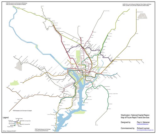
Washington/National Capital Region Map of Future (Potential) Rapid Transit Services. Designed by Paul J. Meissner, for the "Rebuilding Place in the Urban Space" blog.
That program is the basis of what's here, reorganized, because the impetus for this discussion is Amazon's entry into Crystal City. A couple elements have been dropped, although I'd say they're still important.
This type of action plan should be pursued whether or not Amazon comes to Crystal City. But Amazon is a good excuse to bring up the need for visionary planning.
Most of these items are very much Long Term projects with a couple of short term items.
Proposed:
Washington Area Transit Network
Complementary Improvements Program
for Northern Virginia primarily
and Washington DC and Maryland secondarily
in response to the creation of an Amazon headquarters campus in Crystal City
for Northern Virginia primarily
and Washington DC and Maryland secondarily
in response to the creation of an Amazon headquarters campus in Crystal City
2018-2032
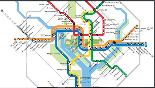
Metrorail
The DC area Metrorail system is a hybrid of "rapid transit" service in the core, mostly underground, and a form of "commuter rail" with a lot of surface stations, outside of the core.
1. Extend the Yellow Line south on Rte. 1 to Fort Belvoir, adding four stations: Beacon Hill; Hybla Valley; Mount Vernon; and Fort Belvoir. (This should have been done as part of BRAC planning, something I first suggested in 2005.)
This would add serious heft to the "Embark Richmond Highway" corridor improvement plans, although would shift from their focus on bus rapid transit. It would also make lower cost areas more attractive and perhaps slake the price appreciation likely to come to many residential housing submarkets as a result of the creation of a new Amaon HQ campus.
2. The map also acknowledges the planned infill Potomac Yard station on the Blue and Yellow Lines, and proposes an infill station, called East Potomac Park, serving the west side of the National Mall near Jefferson Memorial, within DC, to serve visitors to the National Mall.
 3. Alexandria should reverse its decision to restrict convenient access to the Potomac Yard station as a way to reduce costs ("Alexandria scales back design for Potomac Yard Metro, including scrapping South entrance," Washington Post) because this area will experience heightened demand for residential and business activity and transit use as the result of Amazon's entry to the area.
4. Extend the Yellow Line south from Fort Belvoir to Woodbridge. This wasn't in the Meissner-Layman map but perhaps should be. It's 13.5 miles from Fort Belvoir to Potomac Mills/Woodbridge. That's far.
Like the Silver Line, this would be more like "commuter rail" than "rapid transit," but it's a major destination in the area and is worth connecting to, especially because of the traffic effects on I-95, even with toll-based access.
5. Extend the Orange Line west, adding four stations: Fairfax City/GMU; Fair Oaks; Fair Lakes; and Centreville. This would make a busy line even busier.
6. Make Yellow Line service full-time north of Mount Vernon Square in DC to Fort Totten. [NEW ITEM.]
That makes this area have "one seat" access to Crystal City. Currently, the Yellow Line runs north of Mount Vernon on weekends, and during the week in the mornings after rush, and then after rush in the evenings too. Depending on how much the University of Maryland College Park wants to get in on the Amazon thing, it may be worth extending this service to the end of the line in Greenbelt.
Passenger Railroad Service
7. Integrate the MARC Penn Line and VRE Fredericksburg Line into one combined railroad passenger service line ("A new backbone for the regional transit system: merging the MARC Penn and VRE Fredericksburg Lines"). Note that separately, MARC is planning to extend the Penn Line to Delaware (and/or alternatively, extend SEPTA service from Newark, Delaware to Perryville, Maryland).
Use the coming of Amazon to Crystal City as another reason to move this concept forward. The previous entry set a deadline of 2022, with the opening of the Purple Line.
8. Introduce bi-directional railroad service between DC and Fredericksburg in association with the combination of the MARC Penn and VRE Fredericksburg Lines into one integrated service.
With a couple exceptions, currently VRE trains are one way, going into DC in the morning and coming back to Virginia in the evening. Having one continuous line would reduce the need for equipment and train storage, and provide the opportunity for more service in the heavily trafficked I-95 Corridor.
 9. Integrate the Crystal City railroad station into the ground transportation system of National Airport ("A brief comment on ground transportation at National Airport vis a vis VRE rail service") to better leverage railroad access to the airport, comparable to ground transportation and marketing services for the rail connection from the BWI MARC/Amtrak station to BWI Airport.
Separately, the Crystal City Business Improvement District aims to improve pedestrian connections between the airport (CC2DCA Pedestrian Connection).
While the current connections need to be improved, extending the National Airport ground transportation network to the VRE Station will be easier, cheaper, and more practical, since the average person carrying luggage doesn't want to walk that distance anyway.
10. Integrate VRE/MARC fares into the SmarTrip/CharmCard fare media system, using the London Overground as a model ("One big idea: Getting MARC and Metrorail to integrate fares, stations, and marketing systems, using London Overground as an example").
Bus
WMATA has launched a "Bus Transformation Study" looking at the regional bus network ("With ridership falling, Metro will spend $2.2 million to study bus business model," Washington Post). Alexandria is conducting a similar study for its Dash transit services ("DASH Bus Service: More Routes or Faster Service?," Alexandria Living Magazine).
Besides service provided by WMATA, all of the jurisdictions have their own intra-jurisdictional services. Some outlying communities, like Prince William County, provide long distance cross-jurisdictional commuter bus service. Separately, WMATA runs some branded bus services on Richmond Highway (Rex) and Columbia Pike (PikeRide) and a bus rapid transit program between Alexandria and Crystal City (Metroway). Separately, Fairfax County has bus rapid transit plans for Route 7 and Richmond Highway.
11. Improve area bus services as needed with Amazon's entry to Crystal City. Likely more and different services will be needed, and it shouldn't take years as it did to institute bus service from Alexandria to National Harbor. Examples include better north-south bus connections in Arlington, overnight bus service from National Airport to DC when Metrorail is closed, etc.
The transit services in Raleigh-Durham use the same design scheme, assigning a different color to each transit agency.
12. Consider a redesign and rebranding of the the metropolitan area's bus systems into an integrated family of transit agencies linked by a common graphic design treatment, comparable to that of GoTransit in Raleigh-Durham ("Will buses ever be cool? Boston vs. Raleigh-Durham's GoTransit system").
Considering WMATA's Bus Transformation Study, the GoTransit program is a model for bus service integration and coordination versus the balkanized set up in the DC area.
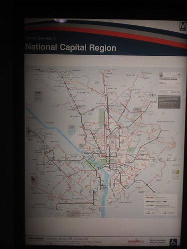
Oddly enough this is the only single posted map I've ever come across that shows the entire Metrobus service profile for all jurisdictions--DC, Maryland, and Virginia. It's out-of-date as it's a few years old and is displayed at the Gallery Place Station at the exit for the Capital One Arena.
13. Integrate various Bus Rapid Transit programs into a unified network (shown on the Meissner map as green lines) with a common system of branding, station design, etc. Albuquerque's ART system is a good model, but there are others such as Viva in Ontario's York Region too.
 Today's Washington Post story on the BRT program in Montgomery County says it will be called "Flash" ("Montgomery County begins construction of 14-mile Bus Rapid Transit line") and has a livery and name different from Metroway.
14. Set the opening of the Purple Line as the deadline for the implementation of a full-fledged integrated Night Owl bus network for the DC metropolitan area.
Use the entry of Amazon as another impetus to create an integrated Night Owl bus network ("Slight revisiting of the issue of overnight transit service: San Francisco").
15. Integrate the long distance commuter bus network into a unified system. This is somewhat the case wrt Maryland in terms of the route network but not in the branding of buses as service is provided under multiple banners/liveries, and the system fails with bi-directional service (such as from DC to Annapolis).
Northern Virginia has separate long distance commuter bus services for each jurisdiction that provides it: Loudoun County; Prince William County; and Fredericksburg. The first two are public agencies (Loudoun Transit, OmniRide), the latter service is provided by a for profit contractor. Each uses a different livery.
Perhaps like with how GO Transit in Ontario has both commuter bus and rail services and one common branding system, in line with my RACER concept for merging MARC and VRE ("One big idea: Getting MARC and Metrorail to integrate fares, stations, and marketing systems, using London Overground as an example"), the commuter bus network in Maryland and Virginia could be similarly rebranded as the RACER commuter bus network, and like with GoTransit in Raleigh-Durham, the rebranding could be launched in part with a common graphic design treatment across the now differentiated fleets of buses. (RACER stands for Railroad Authority of the Chesapeake Region.)
Bi-directional services should be added to certain routes.
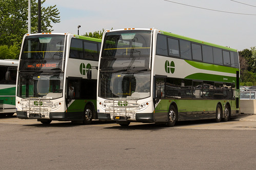 GO Bus also has some double deck buses (see "Making bus service sexy and more equitable") which is something that should be considered also.
In any case, rebranding and repositioning commuter bus service as part of the Washington metropolitan and regional transit network is worth considering as part of an integrated transit network improvement program.
16. Incorporate transit services associated with the I-66 project, Transform 66, into this program.
-- Transform 66 in Northern Virginia - Outside the Beltway: FAQs
-- Transform 66 in Northern Virginia - Inside the Beltway
17. Improve funding for local transit in Prince William County. See "With sustained reduction in gasoline prices, will suburban transit systems lose ridership and revenue?"
18. Incorporate quantum improvements in bicycle infrastructure and facilities across the mobility network in association with the launch of the Purple Line (Item 16 in the PL list). This item has a number of components, including definition of a regional bikeway network ("DC's (lack of full) commitment to bicycle "superhighways": and the counter example of Four Mile Run Trail in Arlington County"), creating a regional bikeways map, creating an integrated system of secure public bike parking stations across the region, etc.
Note that a regional bikeway network is part of the Visualize 2045 Long Range Regional Transportation Plan.
One area specific project would be WABA's proposal for the development of a cycle track network and concomitant improvements in the Arlington Boulevard corridor. Another would be widening and repaving the Mount Vernon Trail, which serves Crystal City.
Crystal City is also the site of one of the region's only bike races, the Armed Forces Cycling Classic.
19. Create a bike mobility hub at National Airport. See "Why not a bicycle hub at National Airport?, focused on capturing worker trips but open to all."
Car sharing

National Airport accommodates Uber and other ridehailing services now ("The popularity of Uber, Lyft boosts airport revenue, but there are trade offs," Washington Post), why not car share?
Given that ride hailing services are taking away parking business, likely spaces could be allocated to interested car sharing programs, beyond that of Car2Go, which already serves Arlington and DC. Enterprise wrested the contract to be located on Metrorail station sites from Zipcar, include them, as well as Zipcar ("Zipcar 'Takes Off' at More than 50 Airports," press release) and any other company interested such as Maven (GM) or Free2Move (Peugeot), etc.
21. Car2Go (one way) car share should expand to Alexandria.
Ferry/Water Taxi Services
Before the development of integrated freeway networks, steamboats provided transportation within the Chesapeake Bay between Baltimore, Norfolk, and DC and within the Mid-Atlantic. I've lived in the DC area since 1987 and I can remember back to at least 1992 proposals for ferries on the Potomac River, paralleling the I-95 corridor.
The studies keep coming ("Fast ferry service in D.C. region possible in near future" and "Regional fast ferry concept moves forward," WTOP radio). And separately, water transportation--I won't call it "transit"--services link National Harbor, Alexandria, The Wharf, and Georgetown.
The problem with the concept is while the river seems so attractive a route, it's not located adjacent to major office districts. The distances to get from a rider's origin point to a river side pier and then at the destination, from a river side embarkation point to the final destination, are considerable.
While water-based transit is still difficult to make work in the DC area, because the rivers tend to not be located proximate to commercial districts, perhaps Amazon's entry will change things somewhat.
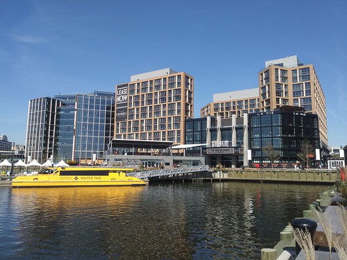 22. Could a water taxi stop be made at National Airport and could it facilitate water-based transit services between the Navy Yard, The Wharf, and National Airport/Crystal City?
 The opening of the Wharf District ("District Wharf embraces DC’s waterfront," Charleston Gazette-Mail) led to an expansion of water taxi services ("The Wharf water taxi service to National Harbor starts," WTOP radio), although I am still doubtful there is much in the way of commuter transportation potential for the service.

London as an example: pricing ferry commuter rides as a premium service. On my walking tour of London with former TfL official Ivan Bennett, we talked about the ferry services there, called the River Bus. In planning for river transit, TfL differentiates between commuter transportation and tourist services.
-- TfL River services
-- London River Services map and guide, Tfl (speaking of branding, it uses the same design style as other London transit services)
-- London River Services map, 2018
Ferry trips on the Thames tend to be slower than rail, but nicer, with coffee service and newspapers. He argues that they should be marketed and priced as premium services, with the extra revenues used to support other aspects of the transit system.
(By contrast, some of the NYC Ferry routes can be faster than rail, because they provide service in areas underserved by the subway.)
That seems like a sensible approach for pricing ferry/water taxi service.
23. Consider developing a pier for Rosslyn water taxi service. [NEW ITEM.]
24. Longer distance ferry services on the Potomac River should be pursued separately.
25. Add summer water taxi service to Roosevelt Island. See "Why not a summer "water taxi" service to Roosevelt Island in the Potomac River." Although this is more recreational, not transit, why not throw it in?
Infrastructure

26. Note that railroad improvements are dependent on reconstruction and expansion of the Long Bridge, the CSX owned bridge that connects DC and Virginia.
The bridge has two railroad tracks used by freight and passenger trains. The Metrorail bridge is separate. It needs two more tracks, which are likely to come as part of a second new bridge span. This is a priority for DC and Virginia currently. (For Virginia, it is part of their "Atlantic Gateway" program.)
-- Long Bridge Project
Note that in the planning for this bridge, I think that there should be a dedicated bus transitway also, providing redundancy and increased capacity for bus transit service between DC and Northern Virginia.
And it will take a lot longer than 6 years, sadly, to build that bridge extension. But because all of Virginia's plans for railroad expansion are dependent on it, it will happen.
-- Atlantic Gateway Project, State of Virginia
WABA has called for additional bike connections across the Long Bridge. Currently, there is a path on the 14th Street Bridge.
New transit connections between DC/Georgetown and Arlington County

Like the "Emirates Air Line" branding of the aerial tram in London, perhaps Amazon would be interested in being the sponsor of this service?
28. If the H Street Streetcar line is extended to Georgetown, perhaps it should be extended to Rosslyn as well. Although ideally Key Bridge would be widened to provide dedicated lanes.
Streetcar service to DC from Virginia ceased as a result of refused access to Key Bridge or other crossings, as new bridges were built and previous bridges accommodating streetcar service were taken out of service.
Previous writings promoted extending the streetcar to Rosslyn and that makes sense especially were there to be a bigger transit hub with the gondola system, but ideally there would be dedicated lanes on Key Bridge.
Labels: fixed rail transit service, sustainable mobility platform, Transformational Projects Action Planning, transportation planning, urban design/placemaking
posted by Richard Layman @ 6:30 AM&Permanent Link
![]()
![]()


6 Comments:
1. If the rumors are true they are splitting "HQ2" then we are taking about 20,000 jobs in CC -- over 15 years.
2. That isn't much higher than what was there before BRAC.
3. The smaller ticket transit things on your list are all good.
4. I'd add pushing yellow line service north of Mt Vernon is also necessary.
5. What would be lacking in CC is easier access to the R-B corridor and Tysons/Dulles on transit.
6. EOTR would not look attractive to amazon commuters. Your area (Takoma, Silver Spring) would.
I think the L'Enfant area as you commented about last week would be, it's an easy commute, and in the city.
But like Reston is urban lite but urban enough and no homeless people, CC might be reasonably attractive.
You're right about one seat rides on the Green/Yellow Line. I guess I missed a point, about keeping the Yellow Line running through DC since it has that Crystal City connection.
Maybe I should go back and pull the "pie in the sky" transit stuff out (Separated silver line, etc.) and put it in a separate entry.
====
in the first piece I thought about the airports thing, not just National but Dulles, but didn't comment on it much. cf. Caterpillar moving from Peoria, but not to Downtown Chicago, but a place with more convenient access to O'Hare, in the suburbs.
I mentioned n-s bus in Arlington as you've raised that issue over the years. Not a real good alternative for Dulles other than transferring at Rosslyn, or going to L'Enfant and transferring there.
You could do a Logan Express type bus operation, if there is demand.
===
wrt pre-BRAC, and I am not an economist, would be the multiplier effect of Amazon jobs vs. military jobs. Then again, lots of related contractor jobs in NoVA as a result of military.
But yep, 20-25K jobs isn't as good as 50K.
===
other coverage out there such as from Vox, about how terrible it is to give incentives. Yep, generally doesn't work out. But Amazon is an outlier. The money in incentives will be paid back. And it's not like it is money that exists today, and therefore is fungible and available to throw at health care or the homeless. It isn't. The new money ("helicopter money?") is generated by the new development.
But yes, "one seat ride" places will be ok, for people ok with commuting.
wrt your point about EOTR not being particularly attractive to Amazon commuters:
https://www.bizjournals.com/washington/news/2018/11/07/sellers-hope-to-cash-in-on-the-hq2-fervor.html
reminds me of how a restaurant kitty corner from what was going to become the Walmart on Georgia Ave. pushed that as an element of its location when it put the space up for sale (which remained empty for years and years).
According to this Bisnow article
1. the water taxi had 32,000 riders in October
2. The Wharf free bus shuttle had 39,000 riders in October
https://www.bisnow.com/washington-dc/news/neighborhood/buzzard-point-development-signs-james-beard-winning-chef-looks-to-build-new-pier-94846
11/9/2018
An article in the Washington Post said that 55% of Amazon workers in Seattle commute by sustainable means (bike, walk, transit) and also that the firm pays for transit passes.
https://www.bizjournals.com/washington/news/2023/06/13/crystal-city-amtrak-station-construction-start.html
"Construction on new Crystal City Amtrak station could begin in 2025"
As planned, Amtrak services would be housed within a planned relocation of the Crystal City Virginia Railway Express station, with passengers accessing the larger train service via a ramp connecting the platform with the VRE. The new station will be located on Crystal Drive between 12th Street South and Airport Access Road, about a quarter-mile from where the current VRE station sits today and from the Crystal City Metro station. The Amtrak platform will include a stationhouse with a passenger waiting area, baggage storage and other Amtrak services, according to Amtrak. A planned pedestrian bridge would ultimately connect the train station to Reagan National Airport, according to the VRE's website.
Post a Comment
<< Home