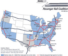
Modified high speed railroad map
I modified the map of the proposed set of "national" high speed railroad corridors to create a more "national" system of connections. (This map from the States for Passenger Rail Coalition is based on a US DOT map.)
It calls for a continuous railroad along both the east and west coasts, going north south, and for three east-west routes between the coasts. I also put in a connection between Louisville and Atlanta. In theory you could create another north-south line going north from Louisville which would ultimately connect to Detroit. (Maybe there would be reasons to have additional north-south service in the Western interior. Even if it couldn't be fully justified for revenue reasons, reasons of redundancy and national security likely would justify such service, even as the Interstate Highway system connects all states as a matter of national interest.
The upper transcontinental route would provide service from Minneapolis to Seattle, the middle route would continue west from Kansas City to Denver, and from there further west to San Francisco, and the lower route would continue west from San Antonio with a likely termination point in San Diego.
The system forsees extensions north from Albany to connect to Montreal, Quebec, and south from San Antonio for service to Laredo, and then to Monterrey, Mexico.
Additionally, a high speed rail route could go west from Boston, picking up the red leg show going from NYC to Buffalo, and then continuing through Canada to Detroit.
Labels: railroads, transportation planning


0 Comments:
Post a Comment
<< Home