Florida Market proof of concept wayfinding signage and the need for a wayfinding conference
The links of the signs that Christopher and I have created have been down for awhile. They've been restored:
- Florida Market Map & Directory
- Florida Market History Sign
We are still doing some tweaks and changes, but the changes to come aren't too significant from what's in the current version. But if you have any comments they'd be appreciated.
One of the reasons that DC has been reticent about creating directory signs of this type is that they have to be updated frequently, and this is costly.
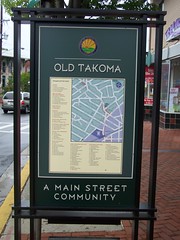
While I haven't priced it out yet, it turns out Takoma Park's directory signage is done in vinyl appliques and is meant to be updated and replaced. I expect this is less expensive than the DC signs (about $6,000 including the base).

Speaking of wayfinding, Christopher writes:
That book on Wayfinding just gets better and better. I just love the way it combines our thinking I also like that it confirms many of the steps that we've done. I think our own project is especially interesting as we've done a prototype and testing phase -- something that seems to be completely missing from all wayfinding projects.
He's referring to this book, Wayfinding Handbook by David Gibson, which masterfully covers the topic.

In a blog entry a couple months ago I wrote:
There are at least 10 separate wayfinding "systems" in the city. They aren't coordinated. We need a wayfinding conference as a start, and then a concordat to start integrating signage into one wayfinding system within the city. (And it's time to assess and update the "blue" wayfinding signage program. Plus, how many years should it take to get the Children's Museum listing taken off signs since it hasn't existed in the H Street neighborhood for at least four years.)
The wayfinding systems (not in ranked order necessarily):
1. The street and highway signage system generally (DDOT);
2. The "blue" wayfinding signage system (DDOT pays for it, the Downtown BID coordinates the system under contract);
3. The heritage trail signage (CulturalTourismDC);
4. signs within areas controlled by the National Park Service;
5. The Architect of the Capitol;
6. Signage/information on bus shelters and in subway stations;
7. DC Department of Parks and Recreation for city parks (they don't really seem to have much in the way of signage, but they should);
8. Intra-campus signage systems such as for the Library of Congress or Catholic University (there are many examples within this category--every college in the city, hospitals, etc.);
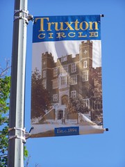
9. Banner programs within Business Improvement Districts and commercial districts, and neighborhoods;

Truxton Circle banner, 1st Street NW
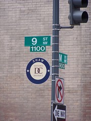
10. The hideous looking signs that DC uses to demark historic districts;

Maybe I am wrong to think these signs are so ugly.
11. While it doesn't exist in a coordinated fashion, a parking wayfinding signage system ought to exist as well (within the context of mobility, not just automobility).

This sign, on 14th Street NW in Columbia Heights, is the first parking wayfinding sign I've seen in the city that actually lists specific parking options/destinations.
In the forthcoming 2009 transportation-mobility wish list (sometime next week it will really be published in the blog, in 4 parts), in the entry on the ideal and complete transportation plan, there is a section on wayfinding systems.
Labels: cultural heritage/tourism, transportation planning, wayfinding


0 Comments:
Post a Comment
<< Home