Military base relocation and sprawl
In honor of Congressman Moran's op-ed in last Sunday's Post about the negative implications of base relocation in Northern Virginia in terms of how the decisions promote driving over transit and other sprawl promoting aspects, "Why Northern Virginia's traffic may be about to get worse," below I reprint (with a couple edits) a blog entry from August 25, 2005.
This paragraph is critical:
My concerns center around the sprawl-promoting aspects of the move. Making Fort Belvoir a bigger regional military center increases car trips because it's not well connected to the current transportation infrastruture.
Clearly, managing transportation impact was not part of the charge in decision making. And as I have said before, in the DC region, the transportation demand management requirements of the Federal Government have some serious gaps, at least as they are expressed in the Federal Elements of the DC Comprehensive Land Use Plan.
Federal facilities, for the most part, should be required to be sited within 0.5 miles of a transit station at the most, and right at the station preferably (see "Pondering the End of a Line" from the Washington Post as one example of why federal facilities should be located immediately adjacent to high capacity transit), primarily subway or light rail (not streetcar), secondarily by railroad or street car, or tertiary by a high capacity bus station. This isn't the case with current regulations, although federal government agencies are required to do significant transportation demand management planning.
Some agencies are more oriented to transit access than others. For example, while the Station Place Development adjacent to Union Station was not welcomed by many H Street neighborhood residents because of design considerations, the location was seen as desirable by the Securities and Exchange Commission, because already more than 50% of their employees used transit, mostly the subway, to get to work. On the other hand, many agencies move farther from the core.

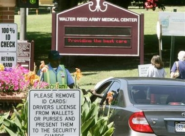
Security personnel checks vehicles entering Walter Reed Army Medical Center in Washington August 25, 2005. A military panel voted on Thursday to close the Walter Reed Army Medical Center, which has treated U.S. presidents and soldiers including Iraq-war casualties over nearly a century in the U.S. capital. (Larry Downing/Reuters)
Today's papers report on the BRAC decisions with regard to various military installations in the Washington region as well as the broader region including "out-state" Maryland and Virginia. Stephen Pearlstein's column in the Post "Base Closings are an open door," argues that these moves will help broaden the business mix and lead to longer term health of the local economy by not being so reliant on the military. (This is also discussed in "TRANSFORMING DC'S OUTDATED MILITARY FACILITIES INTO CITY REVENUES" from the NARPAC website.)
More generally, the State of Maryland is a big winner in this process, as the Baltimore Sun reports in "Panel vote would bring over 7,000 jobs to Md.: Base closing, realignment boosts Fort Meade, Aberdeen Proving Ground; State could end up with largest net gain in jobs."
My concerns center around the sprawl-promoting aspects of the move. Making Fort Belvoir a bigger regional military center increases car trips because it's not well connected to the current transportation infrastruture.
And proposals to extend Metro to Fort Belvoir and even to Fort Meade in Maryland (suggested by state officials in Maryland) will add to the transportation infrastructure, but in a way that makes the newly connected area more likely to be developed in traditional sprawling patterns.
As far as Walter Reed goes, people are probably right that if the District can get control of this property (a very long process as pointed out by Delegate Norton) there will be a long-term net gain to the city as it is likely that most of the people working at Walter Reed are suburban residents.
In the old days, most people lived relatively close to work, and people walked or took streetcars to get to work. For example, perusing Census enumeration sheets for the H Street neighborhood for the early part of the last century finds that hundreds of people work for the Government Printing Office, located a short distance away at North Capitol and H Street, or the Bureau of Engraving and Printing, which spun off the GPO, or at private printers that grew up in the area as a cluster of printing skills developed (e.g, the headquarters of XM Satellite Radio was once a printing plant). Today, if a handful of GPO workers live in Greater Capitol Hill, I would be very surprised.
Labels: military installations and economic development, transportation planning


0 Comments:
Post a Comment
<< Home