Transportation infrastructure as civic architecture: Johannesburg and "Corridors of Freedom"
 Rendering of a pedestrian and cycle bridge linking Alexandra and Sandton across the M1 highway. City of Johannesburg photo.
The Guardian reports, ""A walk to freedom: can Joburg's bridges heal the urban scars of apartheid?," on an equity planning initiative focused on connecting previously segregated and disconnected communities through transportation connections.
I write about how we need to consider transportation infrastructure more decidedly as an element of civic architecture, "like we used to," rather than as a value engineered unattractive means of conveyance. Not only can transportation infrastructure be aesthetically attractive in ways that contribute to community improvement and economic development, connectivity contributes to social and equity planning.
From the article:
Johannesburg was built to segregate people by race. The division was first laid out by the city’s gold mining belt, with black townships in the south and white neighbourhoods in the north. Black areas were then separated from other non-white areas, such as those inhabited by people of Indian descent. The final level of segregation kept apart different linguistic groups within black neighbourhoods, with the aim of reducing the risk of communities uniting against the regime. According to Thabang Sithole, an area planner at the council, this was specifically done with infrastructure, using “barriers like parks or huge vast lands that were vacant, so that the division was clear”.-- Corridor concept for Transit Oriented Development, Johannesburg
For pedestrians in Johannesburg, that has meant harrowing, dangerous and expensive journeys to work – particularly in Soweto and other poorer neighbourhoods. Joburgers unable to afford a car or who live in areas where economic opportunities are scarce can spend up to 40% of their income on transport. But it has also meant a deeper “spatial legacy” of apartheid, with black and white neighbourhoods kept worlds apart, socially and economically. ...
Now, a new project called Corridors of Freedom (CoF) hopes to change this. A transit-led initiative of Johannesburg city council, the idea is to combat this “spatial legacy” of apartheid through urban planning.
The flagship project is to build pedestrian bridges across busy roads and railway lines, to connect once-segregated areas. One such “corridor” has already been completed in Soweto[.] The bridge connects the historic neighbourhood of Naledi with Protea, a newer area that has become a popular place for young people to buy their first homes.
-- "BRIDGE TO OPEN 'CORRIOR OF FREEDOM' BETWEEN ALEX, SANDTON," City of Johannesburg
-- "Westbury's new Corridor of Freedom landmark starts taking shape," City of Johannesburg
Social urbanism and Medellin. I was surprised that the article didn't reference Medellin, Colombia.

Public escalator in Commune 13, Medellín. AP photo by Luis Benavides.
In Medellín, they use the term "social urbanism" to describe the same kind of process ("'Social urbanism' experiment breathes new life into Colombia's Medellin," Toronto Globe & Mail; "Medellín's 'social urbanism' a model for city transformation," Mail & Guardian, South Africa) that Johannesburg is undertaking with the "Corridors of Freedom" initiative.
Medellin has been incredibly successful in reducing the murder and crime rates, having facilitated this through expansive social and civic investments in impoverished neighborhoods, ranging from aerial trams and escalators ("Medellín slum gets giant outdoor escalator," Telegraph) for topographically challenged areas, new and more schools, and "Library Parks," new neighborhood civic centers featuring libraries/community centers, plazas, and open spaces ("Medellín, Colombia offers an unlikely model for urban renaissance," Toronto Star).
The new streetcar unit is more like a light rail car and is manufactured by Bombardier, a Canadian firm that built its transit division on the foundation of the old Budd Company.
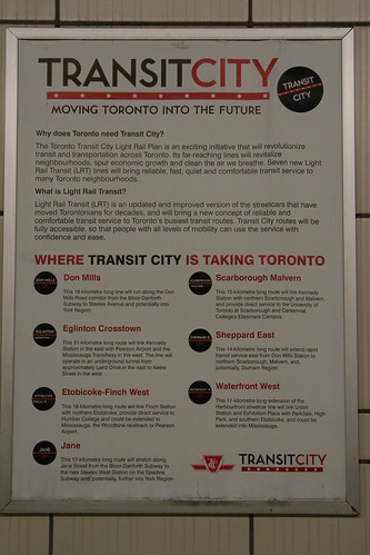 The Toronto Transit Commission developed the Transit City Plan based on principles of both equity--that no one should be disadvantaged because they don't own a car--and mobility effectiveness.
 According to the Spacing article, "The Mayor of Transit City," the program--although it was junked by Miller's successor and since then, transit expansion planning in Greater Toronto has gone through other iterations and changes--called for many changes including:
|
The Transit City Bus Plan (TCBP) laid out a plan for improvement of bus service, complementing streetcar service and working to build a core network of bus routes where service frequency would always be at least every 10 minutes. Toronto already has an overnight bus and streetcar service network. These actions pair with the policy for subway services of a headway of no less than every 5 minutes.
Labels: civic architecture, civic assets, equity planning, public realm framework, social urbanism, transportation planning, urban design/placemaking
posted by Richard Layman @ 10:57 AM&Permanent Link
![]()
![]()


0 Comments:
Post a Comment
<< Home