Sim Civics -- "It's more than the data, stupid!"
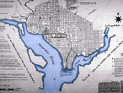 L'Enfant Plan for the City of Washingotn, 1791.
The Boston Globe reports on the use of GIS programs by citizens in planning activities, in the article "Sim civics: New game-like computer software is empowering ordinary citizens to help design better cities. Can the professionals and the public learn to play well together?"
From the article:
Across the United States, in communities from Chicago to Honolulu to Boston, these tools are enabling an unprecedented level of public participation in broad regional planning initiatives. Only when a public is fully engaged in the process, the thinking goes, will it pledge itself and its elected officials to the very real commitments and tradeoffs that are key to effective planning.
The upshot, some argue, is that the crusading populism of our inner Jane Jacobs is edging out those usual suspects, the bleak cabal of Robert Moses-style bureaucrats, developers and industrialists who tend, as the morality tale goes, to callously hold the reins of civic power. But some planners worry that they are losing clout, their hard-won acumen replaced by aesthetically pleasing, dangerously oversimplified gewgaws. As the tools grow in sophistication, can professionals and the public learn to play well together?
Four years ago, Chicago launched what may be the largest exercise in GIS-fueled citizen empowerment to date. Common Ground, sponsored by the Northeastern Illinois Planning Commission, is working to chart the future of the greater Chicago metropolitan region, encompassing 6 counties, 272 municipalities, and 8 million people. The project will turn the Chicago region into a ''working lab for planning and democracy," says program manager Hubert Morgan. ''Everyone has something to learn." ...
Honolulu, during the decade-long tenure of its recently retired mayor, Jeremy Harris, launched a similar, six-year populist planning initiative that culminated in a plethora of awards, including a 2004 UN-endorsed distinction as the world's most livable large city. In 1998, Harris broadcast a prime-time television special to the 1 million islanders of Oahu and equipped citizens with disposable cameras to collect snapshots of areas in their communities needing attention. ... Harris credits much of the project's success to early investments in GIS technology in the 1980s. Honoluluans' crash course in applied public policy ''has raised the bar, permanently," Harris says. ''The increased level of knowledge will be our project's greatest legacy."
.....
But not everyone is so sanguine about this new populist planning. The problem, critics say, is that the visual models produced by software like CommunityViz essentially provide not models but oversimplified sketches. ''It's important to recognize when you're sketching. And these tools are the moral equivalent of sketching," says Charlie Richman, associate director and chief information officer for the District of Columbia's Office of Planning. Richman, trained as a geographer, is adamant that the modeling can only be as good as the data on which it is based. Further, he believes that the public's lack of a deeper understanding of such data can lead to dangerously ill-advised decisions.
''It's the data, stupid," Richman says. ''You need good existing condition data, and without it, you put the community at risk by being wrong. When your only output is a map, it's too easy to get misled, and your scenario plan only reflects back what you already knew."
________
You can get some data, some times, from various DC agencies. You can't hold DCOP responsible for what other agencies do, it certainly isn't responsible for "products" like the City of Washington government's website, etc. And a lot more information is available than there used to be, for which the Williams Administration deserves a lot of credit.
But the city could do more in helping people access and understand this data. It's great that the Social Action and Leadership School for Activists has programs such as "Online Census Data for Nonprofits," but the city could be offering training programs too, including on mapping.
Paul Johnson's Hampden Village-Baltimore Blog makes the point that with the Google Map "hack" capabilities, RSS data feeds from government agencies could lead to incredible mapping capabilities at the neighborhood level--think of it as true CitizenStats.
 "Dear Baltimore City Police Department: First thanks for making crime information easily available online but…. Why can’t your online crime mapping be more like this...Why don’t you just make an RSS feed of crime information I could subscribe to by district or neighborhood?" From Paul Johnson's Hampden Village-Baltimore Blog, August 16th.
(Different crimes could be mapped as different colored datapoints.)
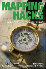
The Urban Cartography blog (associated with the companion Flickr photo group) alerts us to the book Mapping Hacks, which is "a collection of one hundred simple--and mostly free--techniques available to developers and power users who want draw digital maps or otherwise visualize geographic data. The authors do more than just illuminate the basic concepts of location and cartography, they walk you through the process one step at a time. Mapping Hacks shows you where to find the best sources of geographic data, and then how to integrate that data into your own map. This comprehensive resource also shows you how to interpret and manipulate unwieldy cartography data, as well as how to incorporate personal photo galleries into your maps. It even provides practical uses for GPS (Global Positioning System) devices--those touch-of-a-button street maps integrated into cars and mobile phones."
As I keep saying over and over, having greater public access to codified information resources, including computing software resources, on land use, planning, and even public administration issues comparable to what the City of Dallas does with the Urban Information Center made available at the main branch of their public library, would make a big difference in terms of developing informed public discourse along the lines of that popularized by Honolulu's Mayor Harris.
I have commented that I think the way the city government and Mayor Williams have talked about the citizens doing planning rather than having the federal government do it for us scares me somewhat, as the images they use to convey this process (see the NoMA planning presentation Building Center City Washington - Downtown Emerging as Vibrant City Center) strike me as populist without being informed. There's a difference between citizen involvement and cacophony.
We go through all these planning exercises, yet I don't feel that the knowledge base of the average citizen grows with each planning iteration. That says something about the underlying process, it's more than "just the data."
 DC Citizens Summit, November 2003. Caption: Citizen Summit III brought together nearly 3,000 District residents from all eight wards of the city. Participants gathered at 12-person tables to discuss priorities for the District of Columbia. Mayor Williams and Council Chairman Linda Cropp both addressed the crowd to talk about their vision for the city. DC Government photo.
posted by Richard Layman @ 7:26 AM&Permanent Link
![]()
![]()


1 Comments:
I was so anxiuos to know what my husband was always doing late outside the house so i started contacting investigators and was scamed severly until i almost gave up then i contacted this one private investigator and he delivered a good job showing evidences i needed from the apps on his phone like whatsapp,facebook,instagram and others and i went ahead to file my divorce papers with the evidences i got,He also went ahead to get me back some of my lost money i sent to those other fake investigators,every dollar i spent on these jobs was worth it.Contact him so he also help you.
mail: premiumhackservices@gmail.com
text or call +1 7078685071
Post a Comment
<< Home