Open Source Mapping Overview Workshop THIS WEDNESDAY
Another important training that I will miss because I am in Portland, Oregon (more about this later when I see if I can use the computer for a long time at Portland State University...).
From Ken Rubotzky, Chesapeake Chapter, Chesapeake Chapter of the Urban and Regional Information Systems Association. (CCURISA helps advance government geographic information systems (GIS) in Maryland, Virginia, West Virgina, and the District of Columbia.)
I wanted to give people on the DCRG list a chance to consider attending a workshop my mapping group is sponsoring. It's in DC on U Street NW and the cost is relatively low. Mapping and responsible growth tend to go together. Since the cost of mapping systems is down to the cost of your time, with "open source" software, I thought you might be interested. Here's the announcement:
Chesapeake Chapter presents a workshop on Open Source GIS software.The workshop will be held at 1351 U Street NW, 2nd floor, near U Street/African American Civil War Memorial Metro stop on the Green Line.
Workshop opens at 8am and closes at 5pm. There will be a break for lunch, but lunch is not provided. There are numerous eateries within a two block radius. Admission space is limited. Fee will be $40 in advance, $45 for walk ins. This workshop is being held the last week of September on Wednesday, 28 September 2005.
What have people done with open source GIS? Successful open source GIS projects include plotting features of an old missle base property; plotting incidents of Lyme disease in order to project where to place anti-tick treatments; analyzing fatalities on a highway system and fixing dangerous highway segments with similar characteristics; crimemapping.
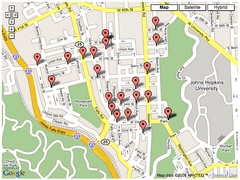
 Google mapping of Baltimore crime data in the Hampden Village area, from www.bosconet.org.
 Learn how to put Google data on this map.


0 Comments:
Post a Comment
<< Home