Transit expansion is a good thing, enabling sprawl is another question
Last summer, I wrote about the State of Maryland talking about the need to expand WMATA "heavy rail" lines deeper into Maryland, particularly to the BWI Airport and points past, in part due to the suburbanization of Department of Defense facilities out of the core of the DC region to campuses such as Fort Meade in Anne Arundel County. When the BRAC proposals came out, I wrote a bit about the sprawl-promoting aspects of the proposals ("Military base relocation"). (This was also discussed recently in the Sprawl and Crawl column in the Examiner, to which I responded blogistically, in "Busing part 2.")
Today's Post has a blurb about the State of Maryland allocating some funds to begin preliminary planning for a "green line" subway extension. The article says:
Maryland officials are asking the General Assembly for $1 million to study the feasibility of extending Metro's Green Line from Greenbelt to Laurel, Fort Meade and Baltimore-Washington International Thurgood Marshall Airport.
The idea of extending Metro by 20 miles to BWI was prompted by military base realignments and Fort Meade's expectation of adding as many as 20,000 jobs in the next 30 years. If the study results are encouraging, state transportation officials said, they would start local and state analysis and federal environmental reviews.
State officials said the Green Line extension could cost as much as $2.6 billion. It is unclear how the project would be funded, but Maryland Transportation Secretary Robert L. Flanagan has said he is interested in getting landowners along the rail line to help fund its construction and operation.
I wrote about this when it was written about in the Sun, but the google search engine for blogs isn't that good for me to be able to find it.
Speaking of transit in Maryland, Paul at Bosconet has written some about the difficulty of getting around Baltimore efficiently via public transit. I was shocked to discover that the MTA website doesn't offer something as basic as a trip planner, an offering that is prominent on the WMATA website.
I don't know Baltimore's spatiality that well to be able to offer a suggested, ideal and optimal transportation system. As a transportation planner that I met recently said, in terms of urban revitalization, "Baltimore has one of everything, and none of it is connected." In a practical sense this means that the Baltimore light rail, subway, and bus systems don't complement one another very well.
I will begin reading the proposed revised Comprehensive Plan of Baltimore to see what they suggest in terms of transportation.
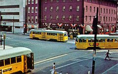
 Baltimore City Hall-the location is Holliday & Fayette Streets. The car with it's doors open is an 8 line car about to turn right on Fayette. The car turning is making the left turn on Holiday from eastbound on Fayette. The car on Fayette is a 15 bound for Walbrook Jct. July 13, 1959 Caption data from Dan Lawrence Frank Pfuhler collection, from Dave's Railpix.
The old Capital Transit system is the model for a goodly portion of the line routing suggested for streetcars in the ongoing DC Transit Future studies. This makes sense, because city development patterns were shaped and in turn shaped the transit system. Likely a study of the old Baltimore streetcar system would shed some important lessons for rethinking transit in the Baltimore region.
Index Keywords: transit; sprawl


0 Comments:
Post a Comment
<< Home