Purple Line supporter
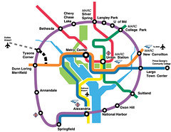
Last night I went to one of the open houses for the "Purple Line" light rail or bus rapid transit proposal from Bethesda to New Carrollton. The major stuff is online at Bi-County Transitway , but it was still interesting.

The people from Prince George's County Advocates for Community Based Transit were there, and I had a good conversation with them. My photo model here is their webmaster and membership coordinator, Tom Reitzel.
Their key members include Jimmy Allen, co-chair, and former president of the WMATA workers union. PGACT meets the second Monday of each month at the Hyattsville City Hall (accessible from DC via the 83-86 buses that leave Rhode Island Metro Station).
 A couple things come to mind.
1. Advocates on the Virginia side ought to be thinking about this system and linking up "circle line" planning on their side of the river.
2. Similarly, remember my point about light rail to and within Annapolis? This system, which terminates in New Carrollton, could continue out to Annapolis.
3. Same with people in Southern Prince George's County. I know that it is a priority issue for the Sierra Club Metro DC campaign to have Metrorail (or some form of rail-based transit) on the Wilson bridge. Would it make sense to do it as part of the light rail system that MTA is looking at, rather than the heavy rail system and cars of the WMATA subway? Or, do you propose some kind of WMATA spur?
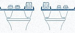 Sierra Club rendering of WMATA subway service on the Wilson Bridge.
I didn't have significant comments at the presentation. Obviously, I prefer light rail. And they were sloppy (inaccurate) with some of their photo captions. The only thing that I commented about significantly was that their planning efforts do not incorporate bicycle articulation planning at the same level that currently exists with WMATA (bike racks at stations, use on trains, etc.). Since this system will run in the WMATA service area (and I imagine it would be run by WMATA, although that decision is a long way from being made), it should plan for comparable bicycle policies at the outset.
My other comment, which I didn't write but discussed with someone, is something that I have been working out conceptually, "transit-shed" transportation planning.
You know the "circles" that are drawn on transit maps, showing the walk- or pedestrian-shed?
Well, I think of these circles as "transit planning" districts. They need to be bigger geographically to incorporate bus planning (they could be drawn to incorporate walking, bicycling, bus, and driving zones) and transportation demand management needs to be planned at that level.
Montgomery County was pathbreaking in re-orienting much of the Ride-On system to providing walkable transit stops within neighborhoods, that would pick up residents and get them to the subway stations relatively efficiently.
This kind of bus planning and re-routing needs to occur in association with the development of this light rail (preferred over bus rapid transit) system.
Index Keywords: transit
posted by Richard Layman @ 6:52 PM&Permanent Link
![]()
![]()


0 Comments:
Post a Comment
<< Home