Train wreck or a Land Use and Development Paradigm Wreck?
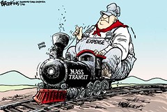 Richmond Times-Dispatch editorial cartoon by Gary Brookins.
Today's Richmond Times-Dispatch devotes its entire editorial column to subway and light rail issues, in the piece entitled "Train Wreck." While it isn't super supportive it makes important points. From the piece:
Centrally planned rail lines move people along specific trajectories in an orderly fashion. Rail seems less chaotic than vehicular traffic. Rail certainly has its place. It provides an efficient means for moving cargo and the safest means for transporting hazardous materials. Yet passenger rail confronts three dilemmas of daunting proportions: cost, ease of use, and density.
When all the capital and operating costs of both mass transit and automobile travel are accounted for, rail travel is almost four times as expensive as vehicular travel. In 2002, rail cost 82 cents per person per mile; vehicular travel cost 21 cents, even after factoring in government spending on roads.
________
I haven't independently confirmed these numbers. My sense is that it's true but inaccurate nonetheless, by lumping in efficient systems with inefficient systems, or at includes high-volume systems like Washington, Chicago, Boston, Philadelphia, and NYC, as well as low volume systems in Utah, Baltimore, Detroit, Pittsburgh, etc., so the numbers get messed up.
For example, while the Dallas Rapid Transit system is being expanded and heralded for its success, its ridership is about 1/10 that of DC's system. Granted we have a more trackage miles...
The editorial acknowledges this stating that:
Mass transit works in places where people are, well, massed together -- such as New York, which has a population density of 26,000 persons per square mile; Chicago, with a density of 13,000 per square mile; and Washington, D.C., with a density of 9,300 per square mile. ...
Why does density matter? Because it enables large numbers of people to live or work within walking or bicycling distance of a transit station. Low density rates force transit systems into an unhappy tradeoff: Either they maintain numerous stations along their routes, which slows travel speeds considerably, or -- for the sake of greater speed -- they maintain just a few stations separated by large distances. The latter option not only makes use of the system inconvenient to most potential passengers, it also requires them to drive to the stations -- which largely defeats the point.
But rather than explain that:
1. Land use and transportation systems development need to be coordinated, and developed in a way that maximizes overall transit efficiency; and
2. Maximizing mobility efficiency shouldn't be left to chance, while it most places that's exactly what happens;
the editorial states that mass transit won't really work in Virginia for the most part because:
Traffic in Northern Virginia is congested because people are traveling from Fairfax to Arlington, from Arlington to Alexandria, from Alexandria to Springfield. In Richmond people want to get from Short Pump to downtown, or from downtown to Courthouse Road, or from Courthouse Road to the Showplace in Mechanicsville. Mass transit for metro D.C. doesn't work in less-dense Northern Virginia. It certainly wouldn't work here in Richmond, where the diffuse population would make the system hugely inconvenient to use -- or astronomically expensive.
Why hasn't Virginia embraced mass transit? Not because citizens harbor an irrational animosity against it. They just are insufficiently dense.
I have been reading the Arlington Virginia Master Transportation Plan Draft and once again, Arlington County, Virginia puts DC to shame. They operate under different conditions, meaning that they don't have the same span of control that DC has--DC makes all of its own laws for the most part, although Congress can and does meddle when it is politically expedient to do so--while Arlington County's laws and regulations can operate only under duly granted authority deriving from the Constitution, Laws, and Regulations of the State of Virginia. For example, Arlington cannot mandate Transportation Demand Management. DC can.
Anyway, read the Transportation Demand Management Element from the Arlington plan and you'll see why the DC Comp Plan bothers me so. Arlington's Transportation Plan systematically addresses overall objectives including TDM, mode, and infrastructure (streets). Each element in the plan covers its role in "Achieving Arlington’s Overall Transportation Goals" which are:
1. Reduce Single Occupant Vehicle (SOV) Trips;
2. Provide High Quality Transportation Service;
3. Establish Equity;
4. Administrate and Manage Effectively;
5. Achieve Environmental Sustainability.
Stating that "Reduc[ing] Single Occupant Vehicle (SOV) Trips" is a fundamental priority of the Master Plan shapes the entire plan, something that the DC Transportation Element really lacks, an overarching goal and framework (imo anyway).
Note to the Richmond Times-Dispatch, Arlington County proves that your conclusion is somewhat incorrect. Virginia's lack of density necessary to support efficient transit options is a choice--either of omission or commission; but it is a choice.
From the Arlington County Transportation Demand Management Element:
Arlington’s early planning for transit-oriented development (TOD) has resulted in its recognition as a premier smart-growth community. A critical component of this smart-growth, Urban Village philosophy is maintaining a network of infrastructure and public facilities to support existing and new development. TDM complements Arlington’s land-use and transportation policies by promoting transportation demand strategies that support transit-oriented, mixed-use development which helps minimize SOV trips.
Transit-oriented development combines convenient transit service with compact development densities. Mixed-use, pedestrian-friendly development situates housing, employment, services and recreational activities in close proximity, linked by high-quality walkways. By offering excellent transit, bicycle and walk options, Arlington’s Metrorail corridors allow for more development density and less reliance on SOV trips than lower-density, single use suburban developments. Arlington’s TOD site-plan development has resulted in a high non-single occupancy vehicle (non-SOV) mode split. In other words, a high percentage of trips to and from transit-oriented development are made by transit, walking, bicycling, carpooling, or vanpooling.
Building walkable, mixed-use neighborhoods well-served by public transportation in the middle of a vehicle dependent region does not ensure success in and of itself. Supplying alternative travel choices does not always guarantee utilization. As such, TDM services are needed to provide information and incentives to encourage a higher utilization of alternative modes.

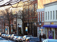 New and old is knitted together in Alexandria with pedestrian-oriented urban design overlaid with transit and transit-oriented development, fully accommodating the automobile. Photos of Alexandria from BeyondDC.
What prevents Northern Virginia from being "sufficiently dense" to support cost- and time-efficient mass transit is the predominant land use and development paradigm--single use zoning, very separated, deconcentrated, and connected by automobile. [Recent studies in Loudoun County use the metric of roughly ten car trips per household per day.]
Arlington proved this paradigm can be changed, and the core of Alexandria City, especially in the vicinity of King Street Metro and in the old city, demonstrates that the walking city of the 1700s still works and is a great city in the 21st century, especially when complemented with transit and transit-oriented development.
 Proposed map of a Washington-Baltimore-Richmond regional rail system © Dan Malouff, Beyond DC.
 One of the comments on this photo within its Flickr entry is "Yes, by all means extend arteries for sprawl all the way out to Hagerstown, Richmond, Harrisburg, and Culpepper. Development in the exurbs is bad enough without making it easier for people to commute two hours into the cities."
To ensure that this doesn't happen, land use and transportation infrastructure development needs to be coordinated, and transportation demand management must be mandated. Also see my writings on mobility-transit shed planning, such as "The Purple Line and the "Mobility" Shed."
Index Keywords: transportation; urban-design-placemaking; sprawl
posted by Richard Layman @ 4:10 PM&Permanent Link
![]()
![]()


0 Comments:
Post a Comment
<< Home