One competitive advantage possessed by the Rust Belt: Water
 Everybody knows that the areas in the United States experiencing the most growth are in the southeast and southwest, places with the least access to water in the country. Increasingly access to water has been described as a limiting factor on "growth."
That's less of an issue in the midwest, especially those states that border the "Great Lakes," New York, Pennsylvania, Ohio, Michigan, Minnesota, Wisconsin, Illinois, and Indiana, plus Ontario in Canada, and Quebec is connected to the Great Lakes via the St. Lawrence Seaway which links the Lakes to the Atlantic Ocean.
The Detroit News ran an AP story, "Book predicts Great Lakes water battles will intensify," about a recently published book, Great Lakes Water Wars, on the subject. Given the fact that most of these states are shrinking in population, and that political power continues to shift south and west, it is not out of the question to foresee much greater strife between regions over expanding access to this seemingly unlimited supply of water.
The Great Lakes Information Network is probably the best place to start out when looking for information about the region.
And this report Paving Our Way to Water Shortages: How Sprawl Aggravates the Effects of Droughts, co-published by American Rivers, Smart Growth America, and the Natural Resources Defense Council, covers the broader issue.
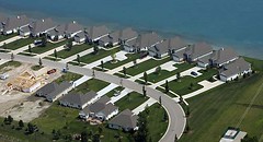 Be careful what you wish for... Shown in the aerial photographs taken in the Port Huron, Michigan and Sarnia, Ontario area on August 3, 2005. Crowding to the edge of the water, rows of houses create a different sort of view of the Michigan shoreline. (Robin Buckson/The Detroit News).
For Detroit News coverage on the impact of sprawl in Michigan, see this special report (28 articles plus images, interactive graphics, video, and a great set of links on government and nonprofit groups addressing Great Lakes issues), "Great Lakes: An Endangered Legacy."
This article from the New York Times, "Living Large, by Design, in the Middle of Nowhere" is about exurban development.
Index Keywords: environment; sprawl
posted by Richard Layman @ 8:07 AM&Permanent Link
![]()
![]()


0 Comments:
Post a Comment
<< Home