North Capitol Street Urban Design & Transportation Study
(I held off writing about this until the meeting location was set) from email:
North Capitol Street Urban Design & Transportation Study
Public Meeting #1
The Office of Planning and the District Department of Transportation, in coordination with the National Capitol Planning Commission (NCPC), will conduct an urban design and transportation study of North Capitol Street from Michigan Avenue to Hawaii Avenue, NE , and Irving Street/Michigan Avenue from First Street NW to their point of union, approximately one block east of North Capitol Street .
The purpose of the study is to:
1. Develop strategies to improve the gateway qualities of North Capitol Street by including civic spaces, memorials, and enhancing the public streetscapes.
2. Explore alternative intersection configurations for the cloverleaf at Irving and North Capitol Streets and automobile ramps at Michigan and Irving .
3. Develop recommendations for improving safety, connectivity and transportation operations.
The neighborhoods that are included in or are adjacent to this area are: McMillan Sand Filtration site, Washington Hospital Center, Armed Forces Retirement Home, Brookland, Petworth, Eckington, Parkview and Bloomingdale.
Tuesday, January 13, 2009
6:30 pm to 8:00 pm
Pryzbyla Center
Catholic University of America
Great Room A
----------------
My response:
I am one of the few people I have ever seen bicycling between Michigan Avenue and Riggs Road on North Capitol. There are issues... especially because the stretch of road between Michigan Avenue to Taylor was built to highway standards. With wide lanes it's very easy for cars to drive in excess of 55mph. The speed limit is 35mph.
a. There is an opportunity, because of the width of the road and shoulders, to install cycle tracks on North Capitol between Michigan Avenue and Taylor Street, however, I have to admit that this location would not be my first priority for installing such in the city.
b. But cycling infrastructure improvements should be considered as part of every urban design/transportation study going forward.
2. It's a great opportunity for the Bloomingdale and Eckington neighborhoods to advocate for the reconstruction of Truxton Circle, comparable to how Thomas Circle was restored a couple years ago.
See this blog entry on making complete places for more.
3. North Capitol is a major route into the city. The signage is very discoordinated. I think this study is an opportunity for a comprehensive reassessment of how the city handles wayfinding and directional signage, with North Capitol being a test case for implementation.
E.g., how we direct people throughout the city to hospitals (Washington Hospital Center, Providence) as well as how we direct people throughout the city to universities (CUA, Trinity). One day last summer I took photos of all the signage going south, from Riggs Road to M Street, but I haven't done a similar survey of the signage going north.
4. During the DC Alternatives Analysis project a few years ago (DC Transit Future), it was determined that the Washington Hospital Center is the number one destination in the city for total trips lacking direct rail-based transit service.
As a result, a proposed crosstown streetcar line was proposed, between Woodley Park and Brookland, with service to the WHC. (In other writings I have proposed that such a line could be extended west to both AU and Georgetown U and east across the DC border to PG Plaza and the University of Maryland.)
This proposal was dropped sometime between the release of that report and the creation of the transportation element in the Comprehensive Plan.
Separately, in the context of the recent Brookland Small Area Planning process, I mentioned this, as well as the likely creation of large developments at the McMillan and AFRH sites, the opportunity to connect these areas with streetcar service as well, to the Brookland (red) and Columbia Heights (green-yellow) subway stations, and to fund this in part through proffers...(Streetcar advocacy did not make it into the final version of the Brookland Small Area Plan.)
With regard to proffers, there is no way that Arlington County or the City of Alexandria would allow projects of such size to be created without associated proffers from the developers. Both jurisdictions tie allowable density of large projects to the level of transportation infrastructure available, and the ability to divert automobile trips. Therefore, if developers want higher density, they pay for it, by paying toward transportation improvements.
Note also that the Portland Streetcar was funded in part by developer contributions as well as contributions from Portland State University.
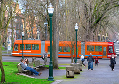
Portland Streetcar near Portland State University. Image from Portland Ground.
posted by Richard Layman @ 6:05 PM&Permanent Link
![]()
![]()


0 Comments:
Post a Comment
<< Home