If you use transit, walk, or bicycle, does traffic congestion on a freeway 10 miles away really matter?
This is in response to the annual release of traffic congestion data by the Texas Transportation Institute. See "Traffic Eases Nationwide -- Except in D.C., Study Finds" from the Post and "Traffic increases, along with Post traffic reporting quality" from Greater Greater Washington.
And note that the TTI studies are of a Metropolitan Region, not of the Center City within these regions.
The problem with most traffic congestion studies is that they focus for the most part on driving on freeways. DC proper has limited the amount of freeways in the city. And therefore you can argue that this induces congestion. There is no question that are major roads into the city, such as New York Avenue (US Route 50), there is significant congestion.
Yesterday morning I was riding down North Capitol Street to a meeting on Capitol Hill, around 7:50 a.m., and while waiting at the intersection with New Hampshire Avenue I joked to myself about how shocked I was to see a Jeep Cherokee with 3 occupants instead of how all the other cars and trucks rushing by had only one occupant. (And why did all those turning vehicles in the far right lane have to veer into the pedestrian crosswalk anyway?)
But how much does that impact DC residents on a daily basis?
Face it, the roads aren't designed to move scads of cars anyway (in the best of circumstances one mile of freeway lane can move about 2,000 cars per hour). And people who choose suboptimal ways of getting around aren't really my problem.
By bicycle--and I don't bicycle very fast (especially because I have wider, but not the widest tires but I admit to occasional envy of riders with racing tires)--I live about 25 minutes from Downtown and from Capitol Hill. The traffic doesn't affect me. And it shouldn't affect others who make smarter choices about mobility and choosing to live where non-automobile mobility is relatively efficient.
Yes, we need to add more transit (and often, additional density to make transit expansion financially efficacious), but more roads? No.
DC's competitive advantage rests upon non-automobile centric mobility. Commuting times for DC residents are close to the national average, while with the exception of Arlington residents, times for residents of other counties in the region can be significantly greater than for residents of the core of the region.
At the same time, in order to better handle mobility demands efficiently and effectively we must expand transit.
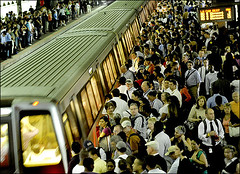
The speed and use restrictions on the Red Line that have been imposed since the terrible accident last month shows how the system can be strained significantly and how redundancy and additional capacity is needed. Photo of full platforms on the Red line subway at Metro Center, DC by Linda Davidson, Washington Post.
That means adding to the fixed rail system, which moves far more people, from 15,000 people per hour (light rail) to almost 40,000 people per hour in one direction, vs. standard or rapid transit bus systems, which move from 6,000 to 10,000 people per hour--if we can provide dedicated bus ways, which in many places in the region, is unlikely.
While some argue that freeways connecting I-270 and I-95 should have been built into the city as was planned in the 1950 Comprehensive Plan, I think that it is proven that highways built primarily for non-residents help cities very little. DC is better off without the freeways.
(Plans were for what is now I-270 to be extended into DC, along both sides of the Metropolitan Branch railroad tracks in Northeast DC. And I-95 was to be extended from College Park to around Fort Totten in DC, connecting to the planned I-70.)
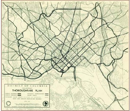
Metropolitan Washington Freeway Plan, 1950.
Labels: car culture and automobility, transportation planning
posted by Richard Layman @ 7:50 AM&Permanent Link
![]()
![]()


0 Comments:
Post a Comment
<< Home