Throwing up my hands and the "Anacostia" "Circulator"
As I have written before, the pretty red buses don't have people thinking straight about what kind of bus service it makes sense to provide within the city. See "D.C. officials mull over Anacostia Circulator" from the Washington Business Journal.
There are three different levels of transit network to consider within the city. The intra-city transit network in turn connects to and is part of the metropolitan transit network, complemented by the suburban transit network.
From my transit network typology:
DC Primary Transit Network: The DC transit network considers the WMATA subway stations within DC as a subsystem of the full WMATA subway network. The primary network is comprised of the 29 subway stations in the inner core of DC (see map below); the proposed streetcar system; high frequency Metrobus and MetroExtra--express or limited stop—service (i.e., 30s, 70s, S, 90s, X, 50s lines); Downtown Circulator bus service; cross-jurisdictional WMATA bus service.
DC Secondary Transit Network: the other 11 subway stations in the city; other WMATA bus service within the city (i.e., 60s, G8); secondary DC Circulator routes (Adams Morgan-Columbia Heights-McPherson Square, Union Station-Capitol Hill-Navy Yard); Georgetown Connector shuttle service; water taxi service if added (based on the likely impact of utilization, which is projected to be minimal).
DC Tertiary Transit Network: intra-neighborhood bus services; private shuttle services (i.e., Washington Hospital Center to/from Brookland Metro, university shuttle services, etc.). This proposed tier of service would be comprised of an intra-neighborhood transit service that could be free (depending on monies provided separately by DC), and oriented to getting people to and from within a neighborhood, to main transit lines and stations without having to drive, and including delivery of goods and services from local commercial districts. The Tempe Orbit bus system in Tempe, Arizona is one model for this type of mobility option.
--------------------------------------

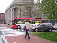
Downtown Circulator bus stop at Massachusetts Avenue and 7th Street NW.
What I didn't state in these writings (because it gets wonky) is that standards or levels of service are set for each segment of the transit network, and in fact how a transit service is defined as a primary, secondary, and tertiary service is dependent on at least three elements:
1. Type of service and its capacity;
2. Breadth of service in terms of area covered;
3. Frequency of service, the levels of which are based primarily on demand.
The pretty red buses, once they get out of the Downtown, no longer have to meet specific metrics for service, because for the most part, they are political bus services designed to make people happy.
The neighborhood circulator buses are 30 feet long, because DDOT managed to convince City Council that the demand of these services would be lower than the Downtown service, which uses 40 foot buses.
By definition a Circulator service is supposed to provide at least 6 buses/hour, or service every 10 minutes.
To justify such a level of service, the total daily ridership ought to be in excess of 10,000 riders/day. Only the Downtown runs meet that level of demand.
I am not against providing better connections between activity centers and transit stations, or connections within neighborhoods. In fact, that is the demand segment that the proposed DC Tertiary Transit Network aims to service.
HOWEVER, you don't serve that demand segment with 6 buses/hour, maybe 2 or 3 per hour is the appropriate level. Of course, it depends. A Adams Morgan-Columbia Heights-U Street (but not going beyond maybe P Street to provide service to the Whole Foods Supermarket) might be able to have more frequent service, at least at certain times of the day, but not the whole day.
But the discussion of the pretty red circulator buses ends up being completely divorced from a rigorous evaluation of optimal service structure for transit and from prudent consideration of the use of limited financial resources.
As a planner, it bugs the hell out of me. And it bugs the hell out of me that other urban bloggers don't lay out these issues, as they are enthralled with the pretty red circulator buses too...
(At least I benefit because the failure to do good planning here helps me figure out things and come up with great concepts... building of course, on the work of others. My joke is that working on these kinds of issues in DC is like working in dog years--you learn way more than one year's worth of stuff in each year.)
Getting back to the article, the first paragraph states:
The D.C. Department of Transportation is considering a new route for the D.C. Circulator bus that would connect the Barracks Row neighborhood of Capitol Hill with Metrorail stations in Anacostia and Congress Heights. The line would be the bus system’s sixth line.
IT MAKES NO SENSE TO DO THIS. You shouldn't provide duplicative bus service between the Anacostia and Congress Heights SUBWAY stations to Capitol Hill. And there is already Metrobus service along Martin Luther King Avenue between these stations (and beyond into the commercial district) already.
PLUS, the 90s buses serve both Congress Heights and Anacostia Stations, as well as 8th Street SE and the Eastern Market Metro Station already. Making an ANACOSTIA CIRCULATOR completely duplicative.
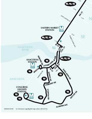
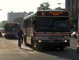
90s bus service map (section) between Capitol Hill SE and the Anacostia and Congress Heights neighborhoods. (WMATA map.) But the Metrobus isn't as cute and cuddly as the Circulator.
WHAT MIGHT MAKE SENSE, is to have the Capitol Hill Circulator (which doesn't make sense as a "DC primary transit network" service, but might make sense as a "tertiary network service" with service a couple times an hour, except during certain periods of the day) take people from the Navy Yard Station to 8th Street SE (Barracks Row).
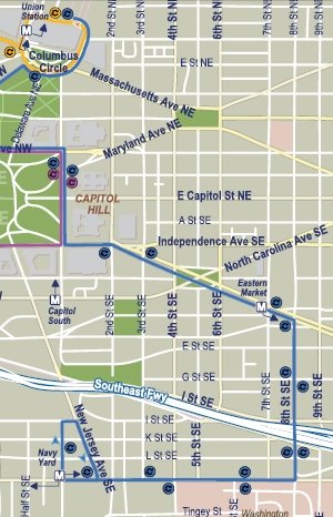
Union Station-Navy Yard Circulator bus map (section from the complete map).
FORTUNATELY, IT ALREADY DOES. So all people who live in the mobilityshed of the Anacostia and Congress Heights green line subway stations need to do is to take the subway to Navy Yard and transfer to the Capitol Hill Circulator....
Labels: electoral politics and influence, provision of public services, transportation planning
posted by Richard Layman @ 5:54 AM&Permanent Link
![]()
![]()


0 Comments:
Post a Comment
<< Home