Getting transit and development backwards
 Usually, transit comes first, then the real estate development. When the development isn't happening, it's often because it's in areas with less transit service compared to other areas. The solution to under-development is adding transit service.
(Photo on right: DC Streetcar at the Downtown Open House in 2009. Wikipedia photo by Tim1965.)
GGW has a post, "McMillan visions take shape," about presentations about development scenarios for the McMillan Reservoir site at North Capitol Street and Michigan Avenue in NW DC, on the border with NW and NE.

Sand filtration vessels, now unused, McMillan Reservoir, Washington, DC
There is a group of area residents who recommend a different course, mostly focused on park related use of the land. Because of the historic nature of this relic of the city's water treatment engineering systems, that isn't an unrealistic desire.
1. Generally, I don't agree necessarily when people fight development based on traffic concerns [especially in the center city where there is a robust transit network], except that
2. For some reason, DC doesn't feel it is necessary to require transportation enhancements as part of development projects, whereas
3. In Arlington or Alexandria, developments on the scale of McMillan Reservoir or the Armed Forces Retirement Home would trigger proffers for transportation enhancement, but such isn't the way things work in DC.
Plus, I had kept making this point of requiring transportation-related proffers during the Brookland Small Area Plan process in 2007/2008, but it never made it into the plan.
I have another entry from 2009, "Will streetcars really return to the Capital City?," about streetcars and the proposed crosstown streetcar line. I recommended building that line first, because there are no restrictions on overhead wires (an issue in the "L'Enfant City") and because at the heart, DC is a very conservative place and people need to see something like the streetcars in action before they can understand and embrace them--I don't see why it's so hard to see how streetcars work in a place like Portland, and imagine them here, but go figure, it's too hard for most people.
GGW has a post, "McMillan visions take shape," about presentations about development scenarios for the McMillan Reservoir site at North Capitol Street and Michigan Avenue in NW DC, on the border with NW and NE.
Sand filtration vessels, now unused, McMillan Reservoir, Washington, DC
There is a group of area residents who recommend a different course, mostly focused on park related use of the land. Because of the historic nature of this relic of the city's water treatment engineering systems, that isn't an unrealistic desire.
OTOH, there is little money around to do so--after all, the site has been abandoned for decades--and the city economic plan prefers that the site be recaptured and in large part redeveloped. Various plans for housing, office, and retail are the result.
In 2008, in "McMillan Reservoir development issues," I wrote:
1. Generally, I don't agree necessarily when people fight development based on traffic concerns [especially in the center city where there is a robust transit network], except that
2. For some reason, DC doesn't feel it is necessary to require transportation enhancements as part of development projects, whereas
3. In Arlington or Alexandria, developments on the scale of McMillan Reservoir or the Armed Forces Retirement Home would trigger proffers for transportation enhancement, but such isn't the way things work in DC.
Plus, I had kept making this point of requiring transportation-related proffers during the Brookland Small Area Plan process in 2007/2008, but it never made it into the plan.
I have another entry from 2009, "Will streetcars really return to the Capital City?," about streetcars and the proposed crosstown streetcar line. I recommended building that line first, because there are no restrictions on overhead wires (an issue in the "L'Enfant City") and because at the heart, DC is a very conservative place and people need to see something like the streetcars in action before they can understand and embrace them--I don't see why it's so hard to see how streetcars work in a place like Portland, and imagine them here, but go figure, it's too hard for most people.
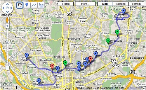
Here's a Google Map version of what I am talking about in terms of a crosstown line.
This line would provide connections to five subway stations: Woodley Park (red line), Columbia Heights (green line), Brookland (red line), West Hyattsville (green line), Prince George's Plaza (green line); six universities (Georgetown, American University, Howard University, Trinity University, Catholic University, and University of Maryland), the Washington Hospital Center, and the Adams Morgan and Columbia Heights commercial districts.
It would also provide economic reasons to intensfy land use development along Queens Chapel Road in Hyattsville, Avondale, and Mount Rainier and especially in the vicinity of the West Hyattsville station, which has a model transit oriented development plan, which has made almost no headway in influencing positive land use changes in that area.
----
But the funny thing in that post is how I missed the obvious point about the crosstown streetcar line promoting land use and land use intensification in DC. (I did list the McMillan Reservoir as one of the points on the Google Map.)
A crosstown streetcar line going east from Columbia Heights would boost a variety of development opportunities that for the most part are unrealized and will remain unrealized for decades:
- Bruce-Monroe Elementary School site at Irving Street and Georgia Avenue NW
- improvements along Georgia Avenue in the area served by a streetcar line
- McMillan Reservoir
- Armed Forces Retirement Home (along Irving Street)
- rebuilding of the North Capitol and Irving Streets interchange into more of a traffic circle
- additional development at the Washington Hospital Center
- Catholic University land west of Harewood Road NE
- the proposed hotel spot at Michigan Avenue and Irving Street NE
- redevelopment of land at the Brookland subway station specifically
- as well as speeding up the development plans of the old "south campus" of Catholic University--south of Michigan Avenue, along Monroe Street, which is being developed by Abdo Development and Bozzuto Development
- redevelopment of land along the rail line north of the subway station, between Michigan Avenue and Taylor Street NE
- and some miscellaneous opportunities here and there
Frankly, this particular streetcar line might have the most real estate build out potential of any of the streetcar lines that are proposed (except for the part of the "H Street" line east of Maryland Avenue serving Benning Road), which for the most part propose to serve somewhat built up areas that lack significant opportunity for redevelopment -- justifiably so since these commercial districts are often comprised of historic buildings.
Therefore, from that standpoint, it needs to be a much higher priority than it is currently, not to mention the transit ridership aspects of this line--adding a necessary higher capacity transit connection to Washington Hospital Center, plus the abutting universities.
It was because of comparable development potential in the Pearl District in Portland and the South Lake Union district in Seattle that real estate interests promoted and developed streetcar service for those areas, in order to realize what was otherwise fallow.
-- article on the development of the Portland streetcar line, including a listing of the various funding sources, including the creation of a local development district (not unlike how DC funded part of the construction of the New York Avenue subway station, through a real estate tax on commercial property in the area to be served by the station) and tax increment financing
This is nothing new. Streetcar lines were developed in DC in the late 19th and early 20th centuries to do exactly the same thing--provide connections to land that real estate interests wanted to sell. "Trolley suburbs" are the product of that kind of development. In DC, neighborhoods such as Mount Pleasant, Chevy Chase in both DC and Maryland, and Friendship Heights are the result.
And, with regard to the streetcar line that Arlington County is building on Columbia Pike, with the participation of Fairfax County, the primary driver of their effort is the desire to repattern and reposition land use and real estate development in that part of the county. Although they are also using the line to eventually serve the Potomac Yards development as well, in association with the City of Alexandria.
DC's Office of Planning, the Office of the Deputy Mayor for Planning and Economic Development, and the DC Department of Transportation should step up and do the same thing for this part of northwest and northeast DC.
Labels: real estate development, sustainable land use and resource planning, transit and economic development, transportation planning
posted by Richard Layman @ 6:20 AM&Permanent Link
![]()
![]()


0 Comments:
Post a Comment
<< Home