Image simulation, streetcar, Georgia Avenue NW
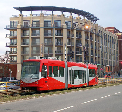
A designer who wishes to remain anonymous created this quick and dirty image simulation of streetcar service on Georgia Avenue. This is at the New Hampshire Avenue intersection, with the Park Place Apartments in the background.
It is quick and dirty (I "commissioned" it last night and got it today and have to turn it in with the full document tomorrow). We know that the tracks wouldn't be placed in the middle of the street, with grass, but we used this photo of the DC streetcar being tested in Ostrava, Czech Republic, where it was manufactured, and married the photo to one of mine of Georgia Avenue.
Image by Michal Rusek.
It doesn't show wires either, not because we are with the Committee of 100 camp about not have overhead wires for streetcars, but because I needed the image by tomorrow, to submit with the Large Tract Review Subcommittee of the ANC4B Square 2986 Committee, which was convened to consider the proposed Walmart on Georgia Avenue, and to make recommendations to the ANC concerning the review process for this project.
Because it's a "matter of right" project because it conforms to the allowable zoning already existing for the site, there is limited opportunity to weigh in on the proposal.
Much of the report focuses on site plan and whether or not it conforms to the intent of the Comprehensive Land Use Plan, opportunities to implement best practice transportation demand management programming to reduce car trips to and from the site and to mitigate potential problems from increased truck traffic, and broader transportation planning and engineering questions triggered by the project, such as the need to reconfigure the Georgia Avenue-Missouri Avenue intersection, as well as to address the impact not just of this development, but of development that will come to the Walter Reed site, and why not use streetcar service as a way to mitigate traffic impact, hence the photo simulation.
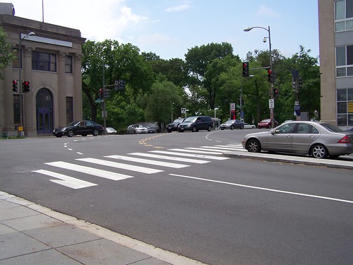
Georgia Avenue-Missouri Avenue intersection, looking southeast from the northeast corner at Missouri Avenue. The intersection is offset, in an S configuration, with a rising grade up to Georgia Avenue from Missouri both eastbound, west of Georgia, and westbound, east of Georgia.
The final report, which is not quite 14,000 words, with 37 recommendations, will be submitted on Monday. I'm not sure how the ANC is going to submit the report, either with or without revision, as part of their overall submission. The document will be made available on the LTR subcommittee website, which I will write about it when it's put up (probably Tuesday).
Labels: civic engagement, commercial district revitalization planning, real estate development, zoning
posted by Richard Layman @ 10:40 PM&Permanent Link
![]()
![]()


0 Comments:
Post a Comment
<< Home