From the files: transit planning in Baltimore County

Image of the Hutzler Brothers Department Store complex on Howard Street, Baltimore, from Monumental City. The subway could connect to the light rail here through a new station constructed in the sub-basement of the Hutzler buildings.
When I worked there in FY2010, Baltimore County was going through the update process for the County Master Plan, and I sat in on some of the meetings related to transportation. They asked me to submit a piece on transit. (I was derisive originally of the county's lead transportation planner, but over time came to realize that his ability to do much in the way of transit related work was constrained by the political and social environment in the county--buses as "loser cruisers", light rail as "loot rail,"etc.)
The document was mostly ignored, because of those same political and social considerations and also because by 2010 the severe reductions in local government revenue were becoming very evident. So the planners weren't allowed to put anything new in the Master Plan that would require new funding.
Anyway, I was going through my files and I came across the document. Might as well publish it now... (with some editing and slight expansion, plus photographs).
Thinking about the transportation element for the Baltimore
County Master Plan
Six principles:
1. Optimal mobility.
2. Linking land use
and transportation planning.
3. Complete streets
and facilities.
4. Transportation
Demand Management.
5. Transit Value
Capture/Funding Mechanisms.
6. Phasing the construction of new infrastructure.
Based on the foundational idea of extending the current fixed rail transit
system in a significant fashion so that it is more robust. And that Baltimore County needs to prioritize its transit needs given the minimal likelihood of the execution of the Baltimore Regional transit expansion plan.
Baltimore Region Rail Transit Expansion Plan Map (adopted March 2002)
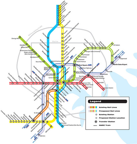
This map shows an eastward extension of the subway in green, and two new light rail lines, the east-west Red line, currently in planning, and the north-south yellow line which is east of the extant light rail line shown in blue, except in its southern portion, which veers west to serve Howard County. The map, in gray, also shows expanded commuter rail services along the Penn Line. The orange line is the MARC Camden line.
The plan below outlined in a paper I wrote when I worked for Baltimore County's Office of Planning was based on the idea that the yellow line will never be built--or at least, not within our lifetimes--and therefore proposes re-routing the light rail line to serve Towson, and on the south, extending light rail service to Columbia in Howard County.
Baltimore Region Rail Transit Expansion Plan Map (adopted March 2002)
This map shows an eastward extension of the subway in green, and two new light rail lines, the east-west Red line, currently in planning, and the north-south yellow line which is east of the extant light rail line shown in blue, except in its southern portion, which veers west to serve Howard County. The map, in gray, also shows expanded commuter rail services along the Penn Line. The orange line is the MARC Camden line.
The plan below outlined in a paper I wrote when I worked for Baltimore County's Office of Planning was based on the idea that the yellow line will never be built--or at least, not within our lifetimes--and therefore proposes re-routing the light rail line to serve Towson, and on the south, extending light rail service to Columbia in Howard County.
1. Optimal mobility.
Many people discuss sustainable transportation (walking,
biking, and transit) and walkable communities in terms of expanding choice and
improvements in quality of life. That’s
true, but choice isn’t the issue. The
question should be framed around the sustainable and optimal use of scarce
resources of transportation infrastructure, natural resources (oil especially),
and the environment.
It's not about having more choices as much as it is about making the right (optimal) choices.
Goal #2 of the Arlington County Master Transportation Plan
is stated as “Move More People Without More Traffic” and it specifically calls
for the reduction of the proportion of single-occupant-vehicle travel and
shifts from motor vehicles to other modes.
In the best conditions on freeways, one lane mile can move
about 2,000 automobiles per hour. On
arterials, the hourly throughput is 1,300 automobiles per hour. Yet, the same amount of lane space can move
from 6,000 to 10,000 people by bus, from 12,000 to 25,000 people per hour by
streetcar or light rail, and from 30,000 to 60,000 people per hour by
subway/heavy rail.
Optimal mobility goals mean that rather than prioritize
automobility, instead, walking, biking, and especially transit must take center
stage.
2. Linking land use
and transportation planning.
Arlington describes their transportation vision in part as:
"… integration of transportation into all aspects of urban
development emphasizes accessibility options and gives priority to the movement
of people rather than only vehicles. As
part of this strategy, Arlington focuses high-density commercial and
residential development around Metrorail stations and corridors with extensive
transit service, while maintaining lower-density residential neighborhoods
elsewhere. Arlington’s vision includes
walkable, mixed-use neighborhoods well served by public transportation and
pedestrian facilities in which residents, employees, and visitors can spend
more time enjoying the attractions of the region and less time traveling."
Linking land use intensification with transit system
improvements and the extension of the transit system makes “transit oriented
development” possible. Currently, the
lack of an extensive system (or network) of reliable transit means that for the most part,
land values do not increase with proximity to the MTA subway or light rail
lines, making it extremely difficult to fund “best in class” TOD projects.
Contrast this to Washington, DC, and
Montgomery and Arlington Counties, where high capacity relatively high quality
heavy rail transit exists. Each of those
communities has benefited from billions of dollars of development projects
driven forward by proximity to quality transit.
3. Complete Streets
and Facilities.*
Complete Streets policies work to ensure that streetspace is
managed so that it is comfortable, safe, and accommodates all users. Currently, most street, streetscape, and
right of way policies prioritize automobiles.
Complete streets policies ensure that pedestrians, bicyclists, transit
riders, and other users, as well as motorists are accommodated.
By extending the “Complete Streets” term to incorporate
complementary transportation facilities, a thorough consideration of all mode
needs can be provided.
The Smart Transportation Guidebook produced by the
Delaware Valley Regional Transportation Commission for the States of New Jersey
and Pennsylvania offers a sound framework to approach the planning of complete
streets and facilities. The Guidebook
outlines roadway, roadside, and operating speed characteristics according to
land use context (seven different zones: rural; suburban neighborhood; suburban
corridor; suburban center; town/village neighborhood; town/village center;
urban core), and further defines these characteristics by type of road, and
whether arterials and collectors serve as “regional” or “community” roads.
Additionally, complete streets and facilities policies
should require that siting decisions for public facilities, especially those
facilities serving the public (schools, libraries, parks, recreation centers,
community centers, health facilities) be made with regard to optimal use of
transportation infrastructure.
Montgomery County’s budget analysis process requires that
pedestrian and bicycle accommodations be considered for all roads, parks, and
schools projects, and for all facilities projects greater than $350,000.
4. Transportation
Demand Management.
Transportation Demand (and System) Management works to reduce
expected increases in travel demand and maintain traffic operation efficiency
by emphasizing optimal use of transportation facilities (streets, parking,
queue management, transit) through robust management and programming.
In the Washington region, federal facilities are required to
do a basic level of TDM planning.
Although federal agencies are not required to locate proximate to the
subway system (a big gap in the TDM requirements), many agencies do so, making
it a priority, and manage to do so despite security concerns and
requirements. For example, located next
to or within one block of either Union Station or New York Avenue Station are
the Federal Judiciary, Bureau of Labor Statistics, Securities and Exchange
Commission, Federal Energy Regulatory Commission, the Equal Employment
Opportunity Commission, Bureau of Alcohol, Tobacco and Firearms (with the
highest security requirements), and units of the IRS. Additionally, federal agencies provide
transit benefits.
Montgomery County has four transportation districts, focused
on mode shift away from automobile trips.
Arlington County has a national best practice program in TDM planning
and programming,
WMATA’s Development-Ridership study of suburban locations
found that offices and residential properties located within 0.0 to 0.25 mile
from a station had from 23% to 35% travel mode share by subway for commercial
properties and from 43% to 54% for residential properties. (For ½ mile, the mode share was 10% for
commercial properties and 31% for residences.)
5. Transit Value
Capture.
In times of scarce financial resources, financing mechanisms
in addition to seeking state and federal funding will have to be developed and
implemented. Tax increment financing
methods, based on anticipated increases in property values, development
projects and the resultant taxes, are most typical. In DC, the New York Avenue Station was built
with three sources of funding, 1/3 from the federal government, 1/3 from the
local government; and 1/3 from a incremental property tax on commercial
property within a certain distance of the station. The extension of the Metrorail to Dulles
Airport is being funded in part with a supplemental property tax on commercial
property. The justification is based on
the reality that property will be worth more as a result of better access to
high capacity transit. DC is considering
some transit value capture taxation as a source of some funding for the
streetcar system it is developing.
The Interstate Light Rail line in Portland, Oregon was
constructed with monies generated by the creation of an Urban Renewal District
and the sale of bonds to be paid from increased property tax revenues generated
by new development in the area served by the transit line.
In order for the transit projects proposed below to go
forward, Baltimore County is going to have to initiate funding outside of the
normal expectations of state and federal funding.
6. Phasing the construction of new infrastructure.
The transit projects proposed below will not be able to be
constructed simultaneously, but all projects should be pursued, funding
mechanisms development, sources of funds identified, and design and engineering
phases completed.
The Baltimore region’s inability to drive significant
investment as a result of heavy rail transit service is the result of the lack
of a real transit network. The subway
line is truncated, the light rail line for the most part follows an old
industrial railroad line and fails to reach many significant residential and
employment districts, and the lines are inadequately connected. The proposals below are designed to create
and extend a transit network for the Baltimore region, allowing for the
repositioning of transit as a choice and desirable service, which in turn will
drive economic development, regional competitiveness, transportation system
efficiency, and other goals and objectives.
a. Connecting the
subway and light rail lines. By directly
connecting these lines, the current transit lines will be able to serve many
more riders. This will serve Baltimore
County by providing a better link from the Western county subway spur, to the
light rail line which serves northern and southwestern Baltimore County.
Such a connection can be made at the Hutzler
Building in Baltimore City.
While physically located in the city, this is such an important requirement for building an integrated transit network that it should be a
key element of Baltimore County’s Master Plan Transportation Element.
b. Extending the
subway line east to White Marsh and additional points, as conceptualized in the
2002 Regional Transportation Plan. This
will double, if not triple, the
ridership catchment area of the transit system.
It will provide connections to the Growth Areas in Eastern Baltimore
County, while also providing additional service to many Baltimore City
locations. Currently, the subway line is truncated, making it much less useful, and significantly dampening ridership.
c. Shift the light rail alignment from Falls Road station away from the current alignment to serve Towson.
The Regional
Transportation Plan also calls for a “yellow line” light rail line roughly
parallel to the current line, along the Greenmount/York Road corridor, serving
the Towson area on the north, and Columbia and other points in Anne Arundel and
Howard Counties. The yellow line is not
being planned at present. It will not
happen within the professional lifetimes of most people working in the
transportation profession in the Baltimore region.
Because the current light rail line has no stations between
Falls Road and Lutherville, and even if it did, few activity centers would be
served and little additional ridership would be generated, and because the
yellow line will not happen any time soon, it behooves Baltimore County to push
forward a different alignment for the light rail line, one that serves Towson,
the number one urban employment center in the County. Either the light rail could be redirected to
Towson from the Falls Road station and rejoining the current alignment at
Lutherville, or a streetcar line could be created to serve the same area.

The red line on this map shows (roughly), the current alignment of light rail service in Baltimore County. The line is located west of Towson. Currently bus service is provided from the Lutherville station. The green line on this map shows how the light rail alignment could be re-rerouted from around Robert E. Lee Park and the Falls Road Station to Towson. The "abandoned" light rail alignment from Lutherville Station to Falls Road Station could then be converted to a shared use walking and biking path/trail. This would solve the problem of finding the alignment to connect the Jones Falls Trail in Baltimore to the North Central Railroad Trail in Northern Baltimore County.
Stations could serve Greater Baltimore Medical Center, Towson University, the Baltimore
County Government and Courts Center, Towson Town Center, Goucher College, and
additional stations south and north of I-695, before rejoining the new alignment to the current light rail
line at Lutherville.
d. The Red Line light
rail line currently being planned by MTA will provide additional high quality
transit service to one of the county’s most significant employment centers as
well as to areas with the potential for significant redevelopment. This effort would only extend the benefits of
proposals a, b, and c.
e. A complementary fixed rail transit program
(light rail, heavy rail, streetcar) could be developed for Eastern Baltimore
County, designed to leverage the proposed extension of the current subway line.
[This is a Howard County oriented proposal and therefore wasn't included in the document, although it was discussed.
f. extend the light rail service to Columbia in Howard County, significantly increasing the reach of the transit network.]
Phasing
1. Subway-light rail
connection. 8 years or less
2. Towson reroute of
light rail 10-12 years or less
3. Subway extension
5-15 years (phased)
4. Eastern Baltimore
County – 12-25 years (phased)
5. Red Line – MTA, 8
years or less.
-----Signature Streets------------------------
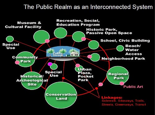
Public Realm as an Interconnected system, Slide from presentation, "Leadership and the Role of Parks and Recreation in the New Economy," David Barth and Carlos Perez, AECOM.
* At the very end of the development process for the Western County Pedestrian and Bicycle Access Plan, I came up with a concept that I called "Signature Streets" but I just didn't have the time to develop it more thoroughly or "sell" it adequately to the advisory committee.
The basic ideas were:
(1) combine complete streets principles
(2) with smart growth ideas (the County has a policy prioritizing investment in extant places)
(3) along with the integrated public realm concepts of David Barth
(4) by designating a subset of the county's road network as foundational or "signature"
(5) and upgrading these streets with systematic special and complete treatment so that sustainable transportation modes (walking, biking, and transit) are integrated into the mobility system (also related is Barth's concept that streets should be treated as linear parks), along with streetscape improvements (the County already has an excellent streetscape improvement program, just not a focus on sustainable transportation)
(6) and justifying using bond funding to pay for the development of the upgraded mobility network and acquisition of the necessary right of way.
See, in counties, to expand the right of way, you have to buy the land. That's expensive. The government doesn't want to do it. But by laying it out in terms of developing a road-based complete mobility network that extends quality of life and how the county "deserves" a road-mobility system that meets its needs in the 21st Century and as the third largest jurisdiction in the State of Maryland makes this kind of re-thinking achievable.
With regard to bond funding, even in bad times, parks-related bond initiatives pass overwhelming in Baltimore County. And this idea is kind of an extension of parks. The model that I suggested was Seattle's Bridging the Gap initiative.
I suggested denoting signature streets with special street signs, not unlike how the City of Toronto has special "sign topper" designations for all sorts of areas in the city.
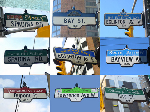
From "Toronto street signs typology" in BlogTO.
Labels: bicycling, planning for complete places, sustainable transportation, transit, transportation infrastructure, transportation planning
posted by Richard Layman @ 7:03 AM&Permanent Link
![]()
![]()


0 Comments:
Post a Comment
<< Home