Another argument for biking transportationally: U.S. commuters wait approximately 40 mins. a day for public transit
This reiterates a point I make often, that biking can be either a great substitute or a complement to riding transit, as a way to significantly improve the efficiency of the trip.
For example, when I lived at 6th and H Street NE, one of my jobs was in Crystal City. I didn't ride all the way to Crystal City but I rode to L'Enfant Plaza Metro and took the train three stops from there, rather than riding from Union Station to Gallery Place and transferring there. Another job I had was in Bethesda and I would ride to Dupont Circle and take the Metro from there.
Those are examples of biking significantly shortening trips by complementing transit. And obviously, trips you can take by bike exclusively are typically much shorter than transit when you take waiting into account.
From the article:
New York City: Respondents spend an average of 149 minutes on public transport each day, 38 minutes (26 percent) idly waiting for the bus or train to arrive, with a 40% dissatisfaction rate
Los Angeles: 131 minutes per day on public transport, 41 minutes (31%) waiting, 43 percent dissatisfaction
Boston: 116 minutes per day on public transport, 39 minutes (34%) waiting, 38% dissatisfaction
San Francisco: 104 minutes per day on public transport, 36 minutes (35%) waiting, 35% dissatisfaction
Chicago: 115 minutes per day on public transport, 31 minutes (27%) waiting, 19 percent dissatisfaction

Image from the Geekwire story "My first bike-sharing ride in Seattle was lots of fun — but not without some speed bumps."
That's something I haven't thought of mapping for the public outside of plans in quite the same way, although it has been done, for example in the publication by VeloQuebec (image below).
It would be a useful element to add to mapping illustrations of my "mobility shed" concept.
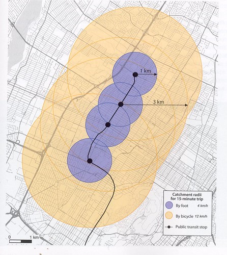
Catchment area of public transit stops for pedestrians and cyclists from Planning and Design for Pedestrians and Cyclists: A Technical Guide. The beige area is the bike shed.
Labels: bicycle and pedestrian planning, bicycling, sustainable transportation, transit
posted by Richard Layman @ 3:45 PM&Permanent Link
![]()
![]()


10 Comments:
I miss the term "rapid transit."
Likewise, on of my complaints about Alta/CABI is they were using a very crude "heat map" for station location - and not thinking of putting stations right on bike routes, or how to use stations to shortcut transit use.
For example, they finally put a station on R on the east side of Dupoint so riders coming in can drop off a bike there then have a easy walk to the station entrance on Q. Makes my red line connection much easier.
I had an interesting meeting with someone who works on massive infrastructure projects (like building transit lines) and he commented about how transit authorities are focused on the real small area around the station, but not much beyond that, and not much in terms of other elements of placemaking. ... and how this dissipates (or prevents the leveraging of) a lot of the value of transit proximity.
I was impressed with Arlington developing a real long range bike share plan, but I am sure it has gaps too.
Anyway, the basic point here is about lack of integration of modes.
I need to update my mobility shed concept, to integrate it more tightly as an organizing framework into the other concepts developed in the writings on "transit, stations, and placemaking."
http://urbanplacesandspaces.blogspot.com/2008/09/updating-mobilityshed-mobility-shed.html
I don't think that we use the mobility shed concept much in planning, but it provides a robust framework for integrating modes at transit stations-activity centers. (Along with "transportation management districts," which we don't do either, except by default, through BIDs.)
2. one of my bicyclepass ideas is to create "service stations" on bike routes with air pumps and repair stands, and parking if appropriate. Such stations could also include wifi points.
another point I forgot to mention and relevant to threads e.g. on GGW when people say "you're trying to make poor people bike, etc." is that 64% of all trips are 5 miles or less. I don't remember the full breakdown, but it's something like 51% of trips are 3 miles or less and 20%+ are 1 mile or less.
Obviously, many of these trips are capturable by bike. In the old days when streetcars came by every 4 minutes, moving around by transit was pretty quick, but it's rare for any bus line to have frequency like that anymore.
Not to mention that while streetcar opponents praise buses as being more flexible for moving around obstructions, biking is eminently more flexible than a bus for moving around backups, congestion, closed roads, etc.
Those walkshed/bikeshed maps irk me when they're shown as just a simple circle surrounding a station. They have no consideration of sidewalk presence, crossing availability, bike facilities, or barriers to any mode, such as rivers, highways, or railroad embankments. They also never seem to consider that even with a well-connected grid of streets, sidewalks, etc., walking distance especially is highly dependent on density and the quality of the built environment. The walkshed around a transit station in a European medieval city center could easily be measured in miles, whereas in a suburban power center it may only be a few few tens of feet.
I have experienced these unfortunate waits, and they often prove to be much longer on bad traffic days or with any modicum of unfavorable weather. As a result, I have almost completely dismissed transit as anything other than an intermediary form of transportation.
To know that the situation is just as bad in cities with better transit systems (I am in Denver) makes me; a) wonder why there aren't more people riding bicycle for sheer utility; and b) think about what we can do to solve the issue.
Public transit is essential in any city that holds merit, and riding a bicycle (even for utility) is just not available to all people. Increasing the viability of public transit as one's sole mode of transportation is going to require at least a few different things (from my perspective).
The problem is that we try to pack as many people as we can onto massive busses and trains. Because there is this capacity, schedules have incredibly large and (and with traffic—unpredictable) gaps in service. Trains are not much different. You reach the platform in some places and immediately resign yourself to jockeying for position on the the train after the next to come through. Good luck.
To reduce wait times and increase comfort and viability we need to have more trains and buses more often that are smaller and more efficient. This would not only decrease the unpredictability, but it would make things like dedicated lanes for transit a viable option. In turn, wait times would become a non-issue.
Furthermore, driverless systems for cars would be incredibly valuable to this type of transit system and real-time monitoring would regulate any argument against transit to the recycle bin.
jeffrey -- I will post something I wrote for the Western Balt. County Ped & Bike Access plan from the design section -- mostly excised from the posted draft and subsequent plan. I had a bunch of subsections on different elements of the experiential quality of certain types of infrastructure related to biking and walking. This section is on transit.
anyway, the point of the walkshed or bikeshed map by distance is the first element. The second, as you point out, is the quality of the infrastructure within the circle, and then the general quality of the built environment.
Generally we don't have good research on it, but anecdotally we agree that the more interesting the built environment, the longer distances people are willing to walk. E.g., in DC, it would be an interesting walk from Adams Morgan to Downtown, which is a couple miles, and many people do it. I think that is the case for many of the neighborhoods abutting the central business districct.
James Tyson -- the other element with transit efficiency isn't just capacity and frequency, it's the length and nature of the route. Generally after 5 miles, except in corridors where there isn't route meandering/deviation, routes degrade in the ability to be "fast".
Transit competes well with cars for trips under 7 miles, especially if you have to pay for parking. After that it depends.
I don't say everyone could or should bike, just that a lot more people could, and it wouldn't be an imposition. cf. Copenhagen, Amsterdam, etc.
2. wrt your point about smaller vehicles, generally that's counterintuitive. The biggest operational (not capital) cost in transit is personnel. Smaller vehicles mean more drivers. And that costs a lot of money (unless you outsource and don't have unions).
One of the reasons that it is difficult to extend BRT experiences from South America to the US is because our wage structure is so much different.
In any case, in cities like DC or NYC or SF or LA or Chicago or Philadelphia, etc., the large vehicles get full during rush periods, even with frequent service.
E.g., on the H Street-Benning Road line, during peak periods the bus comes every 8 minutes. THat's quite good. And most of the buses are articulated. They still can be plenty full.
(Which is why I promote the use of double deck buses, but that's another story.)
Actually I just looked at that transit advice, and it could have been better. In a different part of the draft, I discussed planning bike and ped infrastructure at 5 scales (later I changed this to 6). The most micro scale is 1 mile "sheds" from bus stops and transit stations and schools.
So the point is to have complete sidewalk networks, and as you get closer to the transit stations (there mostly light rail but also subway), the sidewalks are specified to be wider, 8 feet minimum. But in commercial districts too:
http://urbanplacesandspaces.blogspot.com/2012/06/five-foot-sidewalk-in-tunnel-next-to.html
Thanks so much for the site, I found a lot of useful information for us.
Post a Comment
<< Home