Lost opportunity to build cycletrack on Military Road
The GGW entry "It's nearly impossible to get into one of DC's national parks by foot or bike," reminds me that I have been meaning to lament about the lost opportunity to correct a significant gap in the bikeways network, by building a cycletrack on Military Road NW, while the road was being rehabilitated and resurfaced from about 16th Street NW to Connecticut Avenue NW.
Outside of the L'Enfant City portion of Washington, there are very few east-west streets that span Upper Northwest, only three:
-- Michigan Avenue/Harvard Street/Irving Street
-- Taylor Street/Harewood/Upshur (not fully contiguous)
-- Riggs Road/Missouri Avenue/Military Road
None are particularly great for in-street biking. But the section of Military Road, from about 14th Street NW to about 27th Street, on the south side, with a "minimum" of reconstruction, could accommodate a bi-directional cycletrack.
This would have been a complex endeavor because while the roadway is maintained by DC's Department of Transportation, this section is within Rock Creek Park, a national park run by the National Park Service. The proposed cycletrack would be placed entirely on land/right of way controlled by the Park Service, and the process to get approvals, plan, and undertake construction of a cycletrack ends up taking many many years because the federal environmental review process is complex and takes a very long time.
The road reconstruction process would likely have been delayed by 3-5 years for such a review.
I argue the delay would have been worth it, or the project could have proceeded in two phases, because a cycletrack here would significantly improve east-west bikeway connections in Upper Northwest.
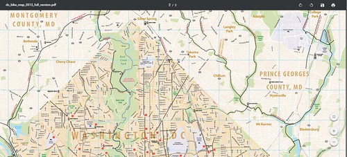
No end-to-end east-west bikeways exist in Upper Northwest, as evidenced by the DC Bike Map, although this would have only been a partial connection.
Still, this section of Military Road is bad for biking because of the limited width of the road, high speed of traffic, and volume of traffic during rush periods (because the road is the only east-west connection north of Michigan Avenue).
To accommodate a cycletrack, some significant regrading would have to occur in parts, and a couple bridges would need to be outfitted with a width extension to accommodate two-way bike traffic.
But with this change, there would be a significant improvement for east-west travel by bike, in an area with only one end-to-end east-west roadway.
The road was reconstructed, but no special accommodations for biking were constructed .. although it is now less dangerous for bicycling because the pavement has been resurfaced. Before this section of roadway probably had some of the lowest scores of the roads as measured by the DC Pavement Condition Index.
Likely the opportunity to put in a cycletrack as part of a regular road resurfacing project won't come up again for 15-25 years.
From the standpoint of creating an integrated bikeways network, I do not understand why there isn't focus on identifying and addressing major gaps in the network.
Note that the Complete Streets policy developed out of the Western Baltimore County Pedestrian and Bicycle Access Plan that I produced sets up a system where road improvement projects are always evaluated for the opportunity to include bikeways infrastructure.
I did attempt to contact DDOT personnel in charge of the reconstruction project, but they never responded to my email queries.
This photo shows the "shoulder" to the right on the eastbound side of Military Road, east of Oregon Avenue

An enhanced, attractive stone median was constructed as part of the project.

Attention was not paid to installing storm drain grates compliant with DC regulations for ensuring safe operation for bicycles. It is easy for a bike to get stuck in this grate, as you approach 16th Street NW. To avoid such dangers, bicyclists must swerve left further into the traffic lane.

The greenway between 14th Street and 16th Street has a desire line or informal "sidepath" which could be re-constructed into a multiuse path for bicyclists and pedestrians. Alternatively, it would be better to install both a sidewalk and a separate cycletrack.

Labels: bicycle and pedestrian planning, capital improvements planning, sustainable transportation, traffic engineering, transportation planning
posted by Richard Layman @ 12:18 PM&Permanent Link
![]()
![]()


6 Comments:
Good call---this should be something that WABA should advocate for.
Even more galling is that a cycletrack on Military is included in the MoveDC plan!
http://www.wemovedc.org/resources/Final/Part%202_Plan_Elements/Bicycle.pdf#page=16
I live off Military and drive on it semi regularly and have been wondering the same thing and lamenting this lost opportunity, particularly since it seems like it would not have been that difficult to add some sort of lane through the park.
Though on the West side of the park Military Road is not a pleasant or safe street to ride a bike on and the sidewalks are not much better.
Including a climbing lane on Broad Branch (which is sort of parallel though not as direct) when it gets re-built is still a possibility but engineering wise will be much more difficult.
What Richard left out of the piece is that the Upper reaches of Rock Creek Park are mostly accessible now via automobile which is ridiculous and terrible policy so a bike lane on Military (or Broad Branch) is not just about creating an E-W bike path but also about improving access to RCP which is great for recreational use but also for commuting to points south.
I should have thought about the park access point too, comparable to the argument in the GGW piece I cited.
In my writings on park planning, I do argue that "local" parks plans should include guidance on parks and open spaces not necessarily within the control of the agency, such as county, state, and federal parks, because otherwise we can't expect "local resident-citizen concerns" to be accurately conveyed to and reflected by those other authorities.
The GGW post, your point, the gist of another GGW post on the Anacostia Park, all make the same point, that access by foot and bicycle (and in some cases transit) is insufficient, car access is prioritized.
I understand some of this has to do with topography and placement of roads, etc., but nonetheless non-motor vehicle access needs to be planned specifically and decidedly.
I do cycle on Military Road when I need to do stuff in Chevy Chase, Friendship Heights, or I want to use the library at AU. It's a nasty experience, but if I am to do it by bike, it's the only way I can go reasonably directly.
2. wrt the climbing lane opportunity on Broad Branch Road, it happens that I am not much of a "recreational cyclist" so I can't say I've ridden on that stretch of road ever, and probably in a car only once or twice, so I am not familiar with it at all.
But I am of course in favor of climbing lanes in such situations.
Thank you for bringing it up.
I can't say I'll have a chance to check it out before the new year, but I will try to do so sooner rather than later.
wrt Anon's first point, a couple years ago I interacted with the W4 member of the BAC and I discussed Military Road's potential for a cycletrack as well as the opportunity for a cycletrack on Fort Totten Drive on the park land.
WRT the latter, some argue that when the MBT is constructed through that general area, you wouldn't need a cycletrack there.
I argued that multiple routes should be supported. A cycletrack could be created from Gallatin to Hawaii, and then on the east side of Hawaii to Taylor Street.
Anyway, he said the BAC was focused on what was already in the bike master plan, not on addressing what I would call evident gaps.
... as you pointed out, the Military Road gap is covered in MoveDC master plan. I don't remember if it was covered in the previous bike plan.
I know that the Fort Totten Drive cycletrack alternative wasn't in the previous BMP, because it predated the widespread awareness of cycletracks as quality infrastructure.
It wasn't til I took a trip to Montreal in 2010 when I was introduced to them on a widespread basis, both within street ROW and in park space.
... Both your comments led me to do a broader piece on this issue, which I just published.
Thank you for furthering along my thinking!
Thank you again for your flawless service, and I look forward to working with you in the future.click it...: https://www.dosepharmacy.com
Post a Comment
<< Home