Some stuff on biking as transportation
1. A couple weeks ago, Now Magazine, the free alternative weekly in Toronto, published 5 examples of groundbreaking bike infrastructure we could use in Toronto," on next generation infrastructure innovations from the Netherlands and Denmark. Two of the items featured:

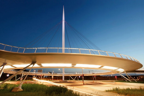
Hovenring bicycle bridge Eindhoven, Netherlands. This "floating" bridge allows cyclists to cross over a highway. The structure replaced a roundabout encircled by separated bike lanes that local authorities deemed unsafe for cyclists. It's not just a marvel of bike infrastructure; it's a statement that beautiful things can happen when bikes take prominence over cars.
(Note I am not a fan of this particular example, because of the impact on the viewshed. I wish there were a better solution. Even a traffic signal...

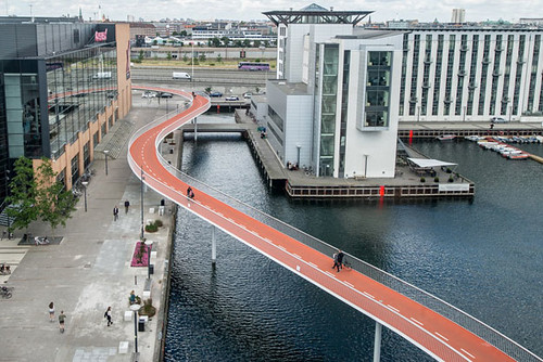
Cycle Snake Copenhagen, Denmark. Copenhagen has much to offer in the way of forward-looking bike engineering, particularly its cycle bridges. But it's the Cykelslangen, or Cycle Snake, an elevated, 230-metre pedestrian and cycle overpass that winds over its harbour, that sets the standard for the new wave in cycling: bicycle highways.
Sadly, this special issue motivated me to check in with the Philadelphia City Paper, which over the years has published many great stories on transportation related issues, including "Let's Go," in 2005, on improving the area's public transit and last year, "I was an undercover Uber driver," on Uber's wild claims of how much money drivers can make, and it turns out the newspaper was acquired by competitors last October, and shuttered. The archives are still up though. The major publications in the DC area aren't as good about publishing vision pieces on what is possible in urban revitalization and transportation.
Bike repair stand and air pump at the Takoma Recreation Center, 3rd Street NW, Washington, DC.
2. The State of Utah Department of Transportation has produced the superb Utah Bicycle and Pedestrian Master Plan Design Guide, to help shape the approach to planning for active transportation by local jurisdictions. It covers virtually every issue outside of programming and enforcement, but could be a bit better on transit-biking articulation and certain elements of support facilities like air pumps and best practice parking options.
3. Note that the Bicycle Collective organization in Utah provides some great parking valet programs, including at the Downtown Salt Lake City Farmers Markets (one of the best farmers markets in the US) and the summer concert series.
5. But I think that these types of facilities need to be "called out" and signage noting their availability needs to be added to community bike route signage systems.
For example, Montgomery County, Maryland has added bike sharing station availability to their bike route signage system.
DC should do the same, as well as create signage for air pumps and repair stands.
The new stand and air pump at Takoma is right on the Metropolitan Branch Trail interim route, yet the average bicyclist is unlikely to even know without signage.
6. The Urban Land Institute has produced a report, Active Transportation and Real Estate: The Next Frontier, covering bike-accommodation-focused multiunit housing developments across the country, featuring ten case studies (although not one of the most prominent examples in Seattle, Velo Apartments in the Fremont neighborhood).
I tried to get a major firm to create a similar kind of development in DC a few years ago--but they just couldn't see it, and their timing was off.
By the time they expressed some interest, they were so close to opening that it was too late, especially because one of the buildings was in the process of being sold off and that company's representatives didn't understand urban biking for transportation at all.
This report will be an important resource for active transportation advocates and professionals across the country, because With the imprimatur of ULI, more developers will consider this now. From the press release:
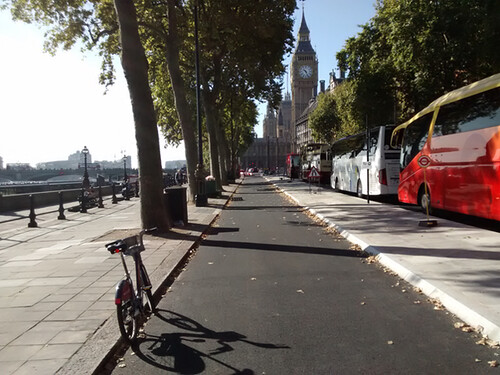
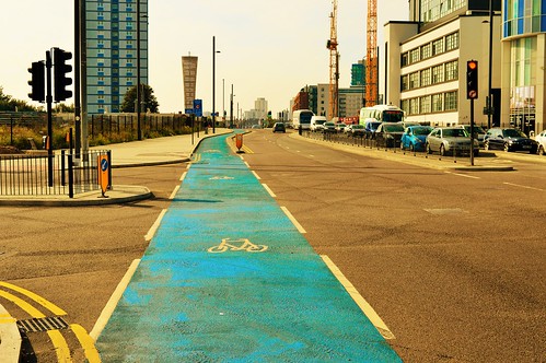
Amenities in the projects include bike storage; extra-wide hallways and bike elevators; a bike repair room; bike cleaning stations; a bike valet; shower and/or locker room facilities; bike parts or a mechanic on site; on-site bike rentals or a bike-share system; a bike park-and-ride system, and direct access to trails.7. The Future Spaces Foundation, an organization focused on London in the context of global cities and architecture, argues that despite London's advances in developing infrastructure to support cycling for transportation, especially now that the original program for "Cycle Superhighways" -- ordinary bike lanes painted blue -- has been modified and more focused on created separated/buffered bike lanes, sometimes termed cycletracks, London is falling behind other cities in supporting bicycling.
The projects show that “leading development practitioners are recognizing the competitive advantage of investing in active transportation amenities,” the report states. “By leveraging and enhancing access to walking and bicycling facilities, they are helping to initiate a win-win cycle of mutually reinforcing private and public sector investment in active transportation in communities around the world.”
Active Transportation and Real Estate also profiles five catalytic active transportation infrastructure investments, such as trails, bike lane networks and bike-sharing systems, which have supported real estate development opportunities. Infrastructure projects profiled are: The Circuit Trails, an off-road trail system winding throughout Greater Philadelphia; cycle superhighways in Copenhagen and London; Midtown Greenway in Minneapolis; and bike-sharing systems in Paris, Montreal, and Hangzhou, China.
Shared themes among the projects include:
Active transportation infrastructure can catalyze real estate development — Trails, bike lanes and bike sharing systems can improve pedestrian and cyclist access to centers of employment, recreational destinations and public transit, as a result boosting the appeal of development near the infrastructure.
Active transportation systems encourage healthier lifestyles – Convenient access to active transportation systems makes the healthy choice the easy choice, helping to improve the fitness and overall well-being of community residents.
Investments in trails, bike lanes and bicycle-sharing systems have high levels of return on investment — Regions and cities have found that relatively small investments in active transportation can yield high economic returns, due to improved health and environmental outcomes.
There is evidence of a correlation between access to active transportation facilities and increased property values – In urban and suburban markets, studies have shown that direct access to trails, bike-sharing systems and bike lanes can have a positive impact on property values.
There is a reciprocal relationship between the private and public sectors in terms of maximizing investments in active transportation – Developers are benefiting from access to sought-after locations that are close to publicly financed active transportation routes; but they are also making direct investments in active transportation by helping to finance improvements to the systems.
The report points to evidence indicating that proximity to bike trails raises property values. For instance, the value of properties within a block of the Indianapolis Cultural Trail have soared nearly 150 percent since the trail’s opening in 2008; and the value of properties near the Katy Trail in Dallas have increased 80 percent. Homes close to Atlanta’s BeltLine have started selling within 24 hours; before the trail project began, homes in the same area stayed on the market for two to three months. And in Minneapolis, every quarter-mile of proximity to an off-street bike facility raises the value of a home by an additional $510.
The study also cites examples of the positive impact of bicycle access on commercial and economic development. In New York City’s Time Square, building rents rose more than 70 percent following the addition of bike lanes in 2010; in both Salt Lake City and San Francisco, the replacement of some street parking with protected bike lanes along specific corridors resulted in higher retail sales in those areas. Meanwhile, in Sydney, Australia, the government concluded that building 124 miles of bikeways would generate more than $350 million (US dollars) in economic benefits.
A press release on their comparison of London to 11 other global cities on biking has been released in advance of the full report--on connectivity, where biking as transportation is but one element--in hopes that they can shape the platforms of the Mayoral campaigns of the various candidates (Labour, Conservative, and Green Parties).

Newer version of cycle superhighways in London.
An older version.

8. I came across the Bicycle Network, the national bike advocacy group in Australia (which is a repositioning and expansion of the bike advocacy group that had been focused solely on the State of Victoria), and they have some amazing programs. Their program Ride2School has led to a doubling of the number of students walking or biking to primary school, to numbers as high as 40% of the student body. Ride2School programming at the University of Tasmania has led to a walk/bike mode split of as much as 60%.
Ride2Work promotes bike commuting and The Happiness Cycle is a program working with teens.
Photo from the Citizen ("More cyclists pedal Parkiteers, but most commuters drive to train stations").
In Victoria State, they support a model protected bike parking scheme, called Parkiteer, a system of bike parking shelters at railway stations and transit hubs--with 85 locations at present. A $50 deposit gets user an access card that works at every station. There is no ongoing charge for parking.
The program includes active marketing, and like how Montgomery County has signage for bikesharing stations, signage for the Parkiteer program is incorporated into the signage system at transit stations.
Labels: bicycle and pedestrian planning, transportation planning, urban design/placemaking


3 Comments:
I got to ride on the new metro trains the other day.
Enjoyed the little LCD screens with updates. I wonder why they can't give you an update on nearby bikeshare stations and dock availability.
Or have that information inside the metro stations.
Cycle-snake could be interesting in Georgetown to get down from the key bridge. I also think re-building the Aqueduct Bridge as a bike bridge would be nice, although you still have the problem of getting UP to Rosslyn.
The DDOT app integrates bike share and Metrorail and Metrobus transit info. I can't remember about car2go. It only lists two way car share "locations" not availability, if they are in the public space, not the full inventory.
That was one of my criticisms, plus the need to integrate RideOn and other services as needed. RideOn has a big presence at Takoma and Friendship Heights of course. They also serve a few locations within DC (Sibley Hospital).
.... I was doing some research this weekend and found out that in SF Bay, Puget Sound, and Minneapolis-St. Paul, their transit media card systems work with the rail commuter services. For PS, even the Amtrak Cascades program.
... I have a whole lot of thinking on these kinds of system integrations and with media that I wish I could go in on with Transit Screen etc.
The thing is that they are "media" not so much "transit." Transit Screen is focused on "transit".
These are dif. systems.
Today there was a private meeting of stakeholders on visioning for the first set of goals for the DC State Rail Plan and I mentioned this and the lousy TPB. One of the things I realized while there, is that to save money, WMATA could sell SmarTrip to the COG/TPB. Note that in Ontario, they use one platform for all the transit authorities in the province. I don't remember if they call it different names between jurisdictions, e.g., it's PRESTO in Toronto. But what is it called in Ottawa City?
But with those rail integration programs, the respective MPOs are much more robust than the COG's TPB and in Minneapolis, the MPO actually "owns" the transit system.
It's been a long time since I looked at the DDOT application, called RideDC.
It does have real-time info on Bike share, as well as Car2Go. But you can't click on Car2Go and get an exact address, the way it works within the C2G system.
But these kinds of transit screens ought to be posted in the train stations.
On trains, I imagine you could set up screens in each car where this info by station could be accessed.
2. a problem with the DDOT application (and I wrote about this when it was first released) is that it is very restrictive on how you can set the boundaries. E.g. for me, one bus line is 2.5 blocks away west, and another is maybe the same distance southeast.
But the application limits its perimeter to 2 blocks. SO I can't see those buslines. It does show the Car2Go parked in front of our house...
Post a Comment
<< Home