The most basic solution for "transit deserts" is adding transit
NextCity reports, "New York City Council Wants to Find a Cure for Transit Deserts," on how the NYC City Council has charged the city's transportation department with addressing transit deserts. The City Council action likely is a response to discussions touched off by the production of transit desert maps produced by Chris Whong ("A new map of New York's 'transit deserts'," CityLab).
The white areas in the map are outside of a 10-minute walk to the city's rapid transit lines.
From the article:
“We know that major portions of the city are not connected to subway service and are left to rely on cars or long walks to get to subways or take unreliable bus service,” says Russell Murphy, Rodriguez’s deputy chief of staff. “We wanted the city to take a look at this and really develop a road map to connect those communities. If not necessarily by new subway construction, at least they’ll develop new strategies to ensure the communities are accounted for.”Marin County/San Francisco Bay. Separately there is an opinion piece in the SF Chronicle discussing the opportunity to add transit to Marin County, by putting rail transit on the Golden Gate Bridge ("Bay Area needs transit plan that includes Marin.
Apparently it had been considered during the initial phase of planning for BART, but the Bridge Authority was opposed, even though engineering studies asserted that the bridge could support the weight of trains.
The article quotes Bill Stokes, one of the founders of the Bay Area Rapid Transit system, who used to say:
“Build it now. It will never be cheaper.”
 Note that Sonoma and Marin Counties are in the process of launching a train service called SMART, and it includes a parallel cycling-pedestrian trail as part of the program.
 Granted providing rail transit connections to Marin (and Sonoma) isn't a matter of providing mobility access to the impoverished, but it is still an important element of transportation demand management and expansion of the area within the metropolitan area that is accessible for workers of all income levels.
Solving transit deserts. The solution to transit deserts is adding transit. And it doesn't get any cheaper, the longer it takes to build, the more it is put off.
In any case, using the frame of "transit desert" as a way to outline improvements and extensions to transit systems ought to be a basic element in outlining transit system planning in master transportation plans.
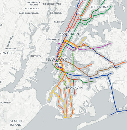
In NYC, they are adding more ferries to the transit mix, a new line launched yesterday ("To Rockaways Residents, New Ferry Service Is A Promise Kept," New York Times)
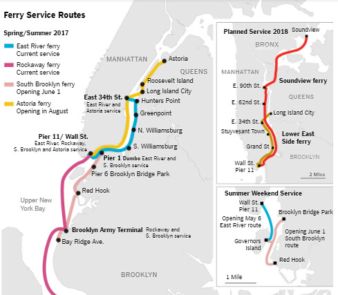
New New York City Ferry Service Map. NYT map.
While there aren't plans to execute such proposals, many people have outlined ways in which existing railroad lines and previously used railroad rights of way could be better leveraged to provide more intra-city transit service. These proposals are from the Transport Politic blog:
-- "Regional Rail for New York City - Part I
-- "Regional Rail for New York City - Part II"
-- "New York Regional Rail: A Coda
Another is the Regional Plan Association's Triboro RX proposal.
Note that my sense of the proposed Brooklyn-Queens streetcar--called the Brooklyn-Queens Connector--is that much of its route doesn't make a big difference in terms of applying the transit desert lens ("City Unveils Possible Routes for Streetcar in Brooklyn and Queens," New York Times)."
But if you apply a different lens, in terms of access between boroughs not dependent on connections between Manhattan, it would come out differently. (Although I think the core of NYC is better served by subway/rapid transit services, not streetcar/light rail.)
Calculating transit deserts. Note that the 10-minute walk calculation used in the map produced by Chris Whong is too "hard core" of a definition on which to base billions of dollars of investment decisions.
A 10-minute walk calculation is comparable to the problem of defining food desert as an area outside of a 5- or 10-minute walk to a grocery store, when the supermarket industry organizes the reach of their stores for a five mile radius (called a "retail trade area").
Other factors include:
- frequency of rapid transit service,
- bus line access,
- frequency of complementary bus service,
- adding bikes to the mix as a 20-minute walk to a transit station becomes a 5-minute bike ride
- the density of the transit network (I've written a lot about the difference between the DC and Baltimore areas coming down to DC having a rapid transit network, while Baltimore has a light rail line and a single truncated subway line)
- night and weekend service frequency, etc.
-- Measuring What Matters: Access to Destinations, University of Minnesota Center for Transportation Studies
-- Access Across America, University of Minnesota Center for Transportation Studies
 Access to jobs. Similarly, the Brookings Institution has been doing ongoing work through their Moving to Access initiative, calculating transit provision and access to jobs across a metropolitan area.
 -- The growing distance between people and jobs, Brookings Institution
-- "Transit Accessibility to Jobs for Metro Areas Examined," Governing Magazine
The Brookings results tend to get a lot of media coverage within the various metropolitan areas that they have studied, which probably helps build the stakeholder support for transit, even if the average automobile-dependent person isn't convinced.
Smart Growth America has developed an analytical approach to this question too, which they have only used in studying Baltimore, for the Central Maryland Transportation Alliance and the MTA's coming launch of their bus reorganization that they call Baltimore Link ("Transportation alliance critical of MTA's plan to overhaul bus routes," Baltimore Sun). From the article:
O'Malley said the alliance spent $25,000 to hire a consultant with Smart Growth America to produce the study using computer models of today's MTA transit network and comparing it to the one proposed.-- Will We Be Better Off? Assessing the benefits of the BaltimoreLink plan, Central Maryland Transportation Alliance
According to the alliance's findings, the new routes would, on average, provide access to slightly more jobs, schools and healthy food sources on weekdays. Opportunities would vary depending on where residents live.
People in West Baltimore's Sandtown-Winchester neighborhood would have access to 5 percent fewer jobs with those in East Baltimore's Berea neighborhood able to access 8 percent more, the analysis showed. Access to key job centers, such as Woodlawn, Columbia and Linthicum, would not be improved.
The report also says that the new system would not considerably increase the number of schools that children could access within 45 minutes or less and only "marginally" improves access to stores that sell healthy food.
O'Malley said average travel time under the retooled bus routes would remain at nearly an hour, about the same as under the current system.
Labels: equity planning, transportation equity, transportation planning
posted by Richard Layman @ 5:39 PM&Permanent Link
![]()
![]()


5 Comments:
off topic (a bit) -- PR filed for Chapter 3 "bankruptcy" today which is more like a re-org for debt purposes.
Impact of lower tax rates unclear on muni bonds. Taking away state and local tax deduction will hurt. High income investors might be more interested in muni after this, not less.
(I'd kill for about 50K a year in muni income in DC, tax free).
Again goes back to technocracy. Do I trust a local authority (WMATA, MTA) to run a transit system? Airlines are terrible but at least there is some investment. Transit systems are designed mostly to reward employees at this point.
One of these days, I swear, I will finish part 3 of my response to Trump and infra. Last week, I went to the CG/LA conference (the same group that produced the document used by the Trump Admin., that I wrote about in Jan.). It was provocative (in a good way) in making me think. ...
anyway, one of the items in my part 3 piece is Puerto Rico, as an example of an ignored opportunity in doing big infra projects that have lots of positive impact, long term supra ec. return.
PR's electricity industry is almost 100% reliant on burning oil. Why not convert it to sustainable energies--wind, solar, tidal--in a manner that cuts their costs, improves their air quality, improves their economic status, etc.
One thing though, besides that the electricity is super expensive to produce, the authority gives a lot of electricity away for free, to various governments and nonprofits.
====
wrt the tax proposals, yes, eliminating the state/local deduction hurts high tax states, which tend to be blue...
an op-ed in the WSJ by Alan Blinder wasn't super positive on the proposal, distinguishing between "tax cuts" and "tax reform." He said it is more the former.
good point about it being difficult to figure out what it means for municipal bonds. Theoretically, they should support federalism. But they don't.
I've argued with you before that the ground for urban debates are very old. Goes back to Hamiliton and Jefferson. Arguably even before that.
Fiscal union. Means states can't raise currency. And hence very hard to raise the money for infrastructure projects -- from canals, to damns, to streetcars. etc.
Having the force the feds to do so.
And the 'deficit panic" which has taken places since the late 1970s means that the federal government has been unwilling to issue enough debt to do so. If anything the steady decline of fed funds since then in an indication that the market wants something it can store value in.
Hence the various proposals on GARVEE or infrastructure banks.
PR has a budget about the same size as DC (13B?); debt is near 73. Not really apples to apples b/c a lot of that debt is not controlled by the budget.
But yes why I worry about DC increasing its debt limit!
Hard to balance two strands -- that states need to be fiscally limited, but the feds not. This is the essential problem in the Euro right now, the Germans can't make that leap.
Good point about history. Another reason for the feds doing infrastructure funding was to build support of the states, and to produce connections that linked states, building the nation.
And yes, deficit panics make running the federal govt. f*ing hard when it comes to vision.
Look how hard it was to fund ARRA (not that ARRA is an example of well thought out infrastructure investing). The reason I am fond of "govt. funding" and the value of it comes from seeing various New Deal projects in Michigan, such as dorms at the UM, still in useful life 40+ years after they were built. Obviously, the dams, various national park buildings, courthouses dating to the New Deal, post office buildings, etc., are other examples.
2. I too am more worried than I used to be about DC's debt. Not that we can't fund it, provided we're allowed to grow somewhat, but because of the waste and poor capital decision making. Such as Dunbar.
So if we increase the debt cap some we run the risk of waste. (E.g., the initiative for "distributed" homeless shelter facilities, what a f*ing fiasco in many dimensions, especially in the judicious use of money.)
And then residents might not be supportive of a "slight increase" in population and fight virtually every proposal for density increase.
Separately is the issue of "more density" a la dealing with the Height Act.
... after the hearing yesterday on LED lighting and the streetlight modernization project, there was a scrum around the dais, and CM Cheh said something about the citizens not being fully bought into the good things that can come from the change to the lighting system.
I jumped in and made the point that generally we do a very terrible job at articulating benefits from acts such as these.
I see adding density as enabling neighborhood-based amenities of a variety of types, arts funding, AND HOPEFULLY more rapid and other forms of _better_ transit.
Others just see more people, not making the connection between the addition of amenities and the population increase.
There is a dude on the Columbia Heights e-list who has a bunch of good ideas, wrapped up in various manias. One is that the tax abatements for Donatelli's residential properties are the ABSOLUTE WORST THING IN THE WORLD, destroy the community in some unique special way, and need to be abrogated.
And then use the money to fund a community development effort.
He argues that because the city accounts for tax abatements by ward as "local economic development" that means the money is used for that.
I argue it's merely an accounting convention, and that (1) you need to create a mechanism for such initiatives outside of BIDs and (2) even if it's a good idea, tying it to something that is politically and legally fraught dooms the concept to oblivion.
Not to mention that if you abrogate one contract you have to break them all, otherwise it's a 14th Amendment violation.
In any case a super huge mess, comparable to a city going through bankruptcy.
====
Anyway, it is a struggle to build the city going forward.
Post a Comment
<< Home