From more space to socially distance to a systematic program for pedestrian districts (Park City (Utah) Main Street Car Free on Sundays)

There's been lots of reportage of initiatives in cities across the country to shift roadway space to pedestrian and bicyclists ("(More) People on streets and the coronavirus").
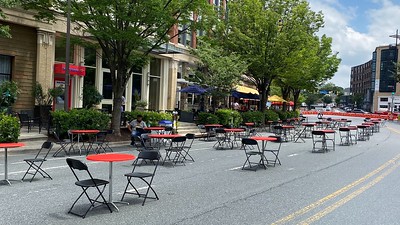
The next stage of this push is focused on accommodating social distancing and commerce by allowing restaurants to expand into the public space outside of their restaurants ("To expand dining options, restaurants take to the streets," Washington Post)..
What is new about this isn't using sidewalk right of way, but street right of way.

Colorful sidewalk extensions into the street right of way even with the curb, Trueform Group
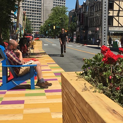
Halifax, Nova Scotia.
I noticed a pop up ad in an article on a Washington Post article that Park City, Utah is doing this as well, on Sundays, for the core of its "downtown" (it's pretty small) Main Street commercial district. (The ad below is from the Historic Park City website and is different from what I saw online.)

-- "Shop, Dine & Stroll || Sundays on Main Street are Car-Free!, Historic Park City commercial district revitalization initiative
The reason that I mention this is that traditional commercial districts should have been doing this all along, long before the coronavirus, as a way to strengthen and call attention to traditional commercial districts as pedestrian and people focused as opposed to car focused.
-- "Town-City branding or "We are all destination managers now"," 2005
-- "Now I know why Boulder's Pearl Street Mall is the exception that proves the rule about the failures of pedestrian malls," 2005
One of the only regularized initiatives like this that I had been aware of before the coronavirus--outside of very special events--is how Denver's Historic Larimer Square has a "Dining Al Fresco" promotion in the summers, where one night each month they close off one of the streets for dining, which is served by the abutting restaurants.


In the face of the coronavirus, Montgomery County, Maryland has developed a similar initiative for its main town centers, Bethesda, Rockville, and Silver Spring ("Bethesda streets close to make space for outdoor dining," WUSA-TV; "Silver Spring, Rockville, Takoma Park close streets to allow for expanded outdoor seating," Bethesda Magazine).
The difference between Park City is that in some of the Montgomery County communities, in particular Bethesda--a leading restaurant destination for Western Montgomery County--this is every day, not just on Sundays or on weekends.
Separately, going on a couple years, Takoma Park also in Montgomery County but a separately incorporated city of its own, is the only community in the area -- pre-coronavirus -- to have legalized the ability for restaurants to take over abutting parking spaces as restaurant patio spaces.
Parking space patio outside of the Takoma Beverage Co.
This is an example of implementing measures that have been developed from the parklet movement, which started out as a guerrilla and tactical urbanism initiative but is now a mix of guerrilla and officially-sanctioned projects.
But it's a limited takeover of parking spaces, not an expansion into the entire street (although now Takoma Park is doing that too).
Moving from temporarily closed streets to permanent pedestrian districts? While in the past I have been pro-pedestrian, I had been skeptical of pedestrian-only zones in the U.S., having seen multiple examples of failure, including the US's first example of a downtown pedestrian mall, in Kalamazoo, Michigan.

But visiting Germany in 2014, I saw such districts of varying types and sizes in Essen, Dortmund, and Hamburg, and in 2018, in Liverpool--a very large district in the core--and smaller areas across London, and I came to understand that the issue wasn't pedestrianizing per se, but in starting small--as little as one block--or at least appropriately, in those places where there is enough activity, access and movement to make such places ("wildly") successful.
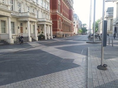
Exhibition Road in Kensington borough is a shared space, mixing cars and pedestrians. It looks cool, but it doesn't work for either pedestrians or cars.
While shared spaces might work in the Netherlands, where they originated ("Hans Monderman obituary," Guardian, I don't think they work in car-dominated societies like the US or the UK. Instead, it's an example of what I call "designing conflict in," which creates the opportunity for problems, rather than what planning is supposed to do, which is "designing conflict out."
-- "Exhibition Road -- review," Guardian
-- "MP calls for pedestrianisation of Exhibition Road amid dispute over accident figures," Dezeen
I wrote about one such opportunity for creating a pedestrian district in DC in more detail last year:
-- "More about making 17th Street between P and R a pedestrian space on weekends."
Unforunately, instead, DC Department of Transportation and Washington Area Bicyclists Association are fervently in favor of adding a cycle track to the street.
But there are multiple places where this could work, elsewhere in DC and the metropolitan area, and of course, across the country, starting with as little as one block, and working outward, expanding as success dictates and warrants.
-- "Making "Downtown Silver Spring" a true open air shopping district by adding department stores," 2018
-- "Revisiting the Purple Line (series) and a more complete program of complementary improvements to the transit network," 2019
-- "Sadly, DC won't show so well during the Baseball All-Star Game," 2018
-- "Urban design considerations for the area around Washington Nationals Baseball Stadium in advance of the 2018 All-Star Game, 2017
Earlier this year, Alexandria, Virginia began moving forward on expanding the pedestrian area at the foot of King Street ("Alexandria Virginia looks to pedestrianize the foot of King Street abutting the waterfront").
While Essen's district was super cool (inadvertently I was there during a weekend music festival and my hotel was across from a major plaza, Kennedyplatz), and Hamburg's very successful and including a transit mall, and Liverpool's was very large, and on a Friday night, it was booming, one that impressed me the most was Mare Street in Hackney Wick borough
It's a couple block long "pedestrian mall" for a shopping and civic district adjacent to the Hackney Central London Overground station.

Mare Street/Narrow Way, Hackney borough.
It turned out the walking street, which looked like it had been there forever, was only a converted a few years before. And it was controversial ("Concerns that pedestrian zone in Hackney Central will kill off trade," Hackney Gazette). Although it looked plenty successful to me, 5 years later.
But my experience in the UK and Germany, and of course there are many other such places not only in various countries in Continental Europe, but across the UK, did in some respects reiterate my concerns about success.
While I think it's possible to have small pedestrian districts in the US, most places lack the concentration of population, strong activity centers, and complementary transit systems that make these districts not only work but thrive in Europe ("Walk the Lijnbaan: decline and rebirth on Europe’s first pedestrianised street," Guardian).
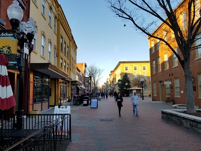
In the US, there are a few pedestrian malls that thrive--Boulder, Burlington, and to some extent, Charlottesville and Madison--but all are in college towns where there is a dense population of students, most without cars.

Charlottesville.
Santa Monica and Winchester, Virginia are among other places that have such pedestrianized spaces. The one in SM is cool, but it's lost key anchors and peters out at the ends, even though one end now includes the terminus of the Expo Line light rail. Winchester has the same problem, although it has none of SM's advantages--resort community, nearby beach, awesome weather, large population, and transit connectivity.
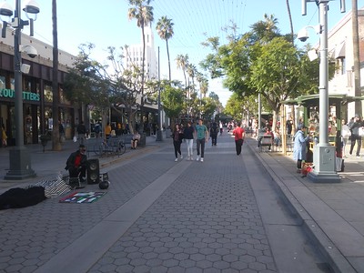
Santa Monica.
Winchester
How to look at expanding pedestrian facilities systematically in the coronavirus era and beyond. Transit. I just came across a January Chicago Tribune article about how the Chicago area transportation planning organization, for the first time, released a study evaluating the pedestrian and bicycle access conditions at the region's railroad and heavy rail transit stations ("Where do I walk? Study finds several Metra, and some CTA stations, have a shortage of nearby sidewalks").
From the article:
A lack of sidewalks near several suburban Metra stations and a few CTA stations makes it harder for pedestrians to safely walk to transit, according to a new, first-of-its-kind report by the Chicago Metropolitan Agency for Planning.What's amazing to me is that this had never been done before--although note that the Active Transportation Alliance had received grants to do similar geographic-specific studies over the past decade. And why isn't this a standard element of station area planning from the outset.
“If people don’t feel comfortable walking to the train, they’re not going to use the train,” said Stephanie Levine, associate policy analyst for CMAP.
The analysis found that within half a mile of stations, just 35 out of 242 Metra stations had “excellent” coverage with sidewalks on one or both sides of almost all roads. Eighteen Metra stations had no sidewalks on 50% of the roads within a half-mile of the station.
Note that Montgomery County just released a Purple Line Pedestrian Accessibility Report for their under construction light rail line ("Purple Line stations need safer access for pedestrians, planners say," Washington Post).
(And in the draft plan I did in Baltimore, I included a section of recommendations for transit-related improvements, including the then proposed Red Line light rail, which ended up not being approved. And in early planning stages for the Purple Line, I was asked to share that section of the planning document.)
I guess that's pretty rare, although Seattle has done this around light rail planning too. The MoCo methodology is worth being adopted more widely.
But the reality is that most transit agencies have failed to ensure that stations are accessible by modes other than cars. In their defense, they'd probably say that the local jurisdictions are responsible for this kind of planning and infrastructure, and they're right, but if they are to be "customer"/rider/service oriented, they need to step on this.
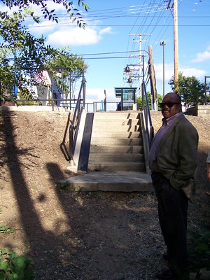
The platform for the west side of the light rail station in Lutherville, Baltimore County, Maryland, has a stairway but no sidewalk connecting it to the nearby street.
Although some agencies are leaders in planning for station access including the Utah Transit Authority ("UTA Works to Overcome 'Toughest Mile' Challenges," Metro Magazine). The report produced out of the UTA project, the First/Last Mile Strategies Study (lead consultants Fehr & Peers), is particularly good.

Catchment area of public transit stops for pedestrians and cyclists. Montreal, p. 135, Planning and Design for Pedestrians and Cyclists: A Technical Guide, produced by VeloQuebec.
The DC area Metrorail agency did a similar study c. 2009, for walking and biking. (Then again, the system had been operating for more than 30 years by then.) There are still plenty of gaps in terms of pedestrian access, intersection treatments, sidewalks, bicycle parking, etc., even though all the city stations have been open for decades.
I remember coming across an article on the bus system in Greater Minneapolis, and a recognition that lack of sidewalks significantly impacted bus ridership in the suburbs especially ("Metro Transit says bus stops are improved with better signs, more shelters," Minneapolis Star Tribune; "Bus Stops as Community Assets," University of Minnesota graduate student project).
I recommend that as part of transit line and station planning, public improvement districts can be created to implement full vertical and horizontal "ground" access programs.
-- "Revisiting creating Public Improvement Districts in transit station catchment areas," 2020, original entry, 2016
Sidewalk and street networks. In response to the coronavirus, Matt Elliott, a contributor to the Toronto Star, wrote a piece ("Where should lanes be closed for pedestrians and cyclists as the city comes back to life? We crunched the data") providing a systematic way to look at areas of high pedestrian use, hospitals, and supermarkets, to identify and prioritize areas where right of way dedicated to pedestrians should be increased.

Toronto's 100 busiest pedestrian intersections, by Matt Elliott.

Blue dots are for high use pedestrian traffic at intersections, red dots are hospitals and major health clinics, orange dots are grocery stores.
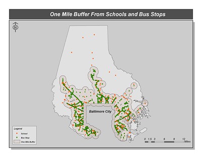
In the Baltimore County study I did, I advocated similar approach, using bus stops and transit stations, elementary and junior high schools, and local commercial districts as the loci.
For a presentation I did in Montgomery County, the County planning department graciously produced a similar kind of map.

One mile radius from transit stops, Montgomery County, Maryland. Map by Matt Johnson.
Conclusion. We have the ability to expand space devoted to sustainable mobility in systematic ways, in ways that promote high quality urban design and placemaking.
I think what we lack is the will to shift space from cars to pedestrians, especially in bold ways.
But too often, our desire may be ahead of where we are practically speaking. At least here in Salt Lake City, the city responded, like lots of other places, and shifted many streets or street right right of way to shared space or bike/pedestrian exclusive zones -- but no one is using them (at least at the times when I check them out).
So we need to be conscious of where we focus such efforts, to ensure that they are successful and visible in positive ways, so that further and future initiatives aren't scuttled in response to failure or the perception of failure.
Labels: bicycle and pedestrian planning, car culture and automobility, commercial district revitalization planning, restaurants, urban design/placemaking
posted by Richard Layman @ 5:36 AM&Permanent Link
![]()
![]()


19 Comments:
I used to bike the section of baltimore light rail when it was being converted, and never understood that Staircase to Nowhere at lutherville. Was there a plan for it to connect to a sidewalk, but the community shut it down "due to crime"? is it a portal to Narnia? And now that it connects to a medical facility will there be an effort for it go somewhere?
Er, I meant the Timonium station.
If you look at current google map of Lutherville station, you see that there is now a wooden walkway connecting the staircase to Talbot avenue. It looks to be new, as streetview doesn't show it.
It wasn't until I worked there that I heard light rail referred to as "loot rail."
And I was specifically told about stories of people coming up from Baltimore to that area, to steal from the stores, how empty boxes of products were left at the light rail station, etc. (Of course, it was a few years later when people in Anne Arundel County fought for the closure of the end line station there.)
Probably residents fought the connection, but I never looked into the history of the lack of connection.
And in the long section from Falls Road to Lutherville where there aren't stations, in the history of the development of the line, yes, residents successfully fought the creation of stations--not that they would have yielded much ridership.
In my writings about this, I proposed abandoning that section and shifting the alignment towards and to York Road, serving Towson directly (and Greater Baltimore Hospital and Towson State in the bargain).
Not unlike how once the Seattle light rail finally extended to Capitol Hill and the university and doubled ridership, serving a major activity center in Baltimore County would result in ridership increases.
(And it was the current sec. of transportation for Maryland, then as planning director for SHA, who made the point to me that by extending light rail 1/2 mile north from Hunt Valley it could better serve the various corporate plazas.)
It's good to see that they have corrected the lack of a connection. Although like with the section north of Falls Road, that side of the station isn't likely to generate much ridership.
NYC car drivers tear down barricades for shared streets:
https://nypost.com/2020/06/28/de-blasios-unenforced-open-streets-causing-neighborhood-tension/
Boston pedestrian bridges:
https://www.bostonglobe.com/2020/06/29/opinion/walk-this-way-celebrating-bostons-pedestrian-bridges/
Funny thing is "loot rail" sightings are like bigfoot. No one has directly seen it, they just heard some account which must be true.
Well, there were a couple incidents in Anne Arundel County. But there are incidents everywhere.
I took a lot of joy writing a response to someone when I worked in Baltimore County. They wrote that bicycle trails generated crime. I quoted from a study from the U of Delaware stating the opposite, but making the point that all transpo infrastructure is associated with crime.
But then I said, many crimes are associated with automobiles, and quoted the County Police Chief saying that. I then wrote. "But we don't shut down the street network..."
... although technically, all emails sent out are supposed to be approved by your supervisor.
A couple incidents out of statistically how many riders?
Fact is, it's generally a stolen car involved in burglary. As you said, where's the call to shut roads down?
Waco "festival street" concept:
https://wacotrib.com/news/local/tif-board-to-vote-on-5-5-million-for-bridge-street-front-porch-project/article_2177d9f6-c756-5c6f-abb0-37c4a7c0aaca.html
Plus the streetscape playbook manual for the Memphis Medical District Collaborative.
https://www.dropbox.com/s/bpuucve0atfu559/15104-MedicalDistrictPlaybook-20160916.pdf?dl=0
WDIV ClickOnDetroit: Downtown Ann Arbor streets closing Thursday to make more space for businesses, pedestrians.
https://www.clickondetroit.com/all-about-ann-arbor/2021/03/27/downtown-ann-arbor-streets-closing-thursday-to-make-more-space-for-businesses-pedestrians/
The Philadelphia Inquirer: Make cocktails-to-go permanent, and six other things Philly restaurants need to survive | Opinion.
https://www.inquirer.com/opinion/commentary/philadelphia-restaurant-reopening-regulations-covid-coronavirus-20210326.html
Among the items it lists is letting neighborhoods close streets for extended periods to support peacemaking, restaurants, etc.
... and invest in "outdoor attractions" designed to bring visitors in. Public art, gardens, live musuc.
In a mobility system that has been dominated by the car it's difficult to get some drivers to recognize a rebalancing in privileges for use of roads.
https://www.ocregister.com/2021/05/02/kia-hops-curb-careens-past-outdoor-diners-in-santa-ana-bystanders-restrain-driver
WGN TV Chicago: Rain doesn’t damper return of ‘Sundays on State’ in Chicago’s Loop.
https://wgntv.com/news/chicago-news/rain-doesnt-damper-return-of-sundays-on-state-in-chicagos-loop/
https://www.ocregister.com/2024/01/25/laguna-beach-to-hold-design-contest-for-permanent-promenade-on-forest-lookPlans to make Laguna Beach’s Promenade on Forest a destination feature will likely be determined by a design competition involving several firms, city officials decided Tuesday, Jan. 23.
The promenade conceived of more than three years ago as a lifeline for restaurants and shops during the pandemic, has been a temporary setup, with the council deciding in 2021 to make the location on Forest Avenue permanent.
Since its conception, the focus has shifted from helping retailers and restaurants with an outdoor space to survive the pandemic to making the lower stretch of Forest Avenue – starting at Main Beach – a community gathering spot and a place for music, street art, and performances. The idea for the plaza is to enhance Laguna Beach’s downtown while maintaining its character and turning the promenade into a destination for locals and visitors.
Laguna Beach to hold design contest for permanent Promenade on Forest look
State Street panel floats ideas to put welcome mat on ‘Chicago’s front porch’
https://chicago.suntimes.com/2023/8/16/23834358/state-street-revitalization-urban-land-institute-chicago
Plans would divide the corridor between Wacker and Ida B. Wells drives into three distinct districts highlighting arts, retail and education.
State Street is “what many consider Chicago’s front porch,” said Michael Edwards, the president of the Chicago Loop Alliance. The idea is to make that porch more welcoming to residents and visitors alike.
A new set of recommendations to revamp State Street, presented Wednesday evening at the Harold Washington Library Center, is focusing on doing just that and highlighting the art, retail and education institutions along the historic stretch.
The ideas from a city-commissioned panel include improving the street’s design to be more friendly to pedestrians and public events, adding art and light displays, encouraging new programs tied to major city cultural happenings, and periodically closing the street to vehicle traffic, as is currently done for Sundays.
• The northern third of the street would be the North Anchor Arts District, creating a consortium of downtown arts organizations that connect to public events.
• The Center Anchor Retail District would be dedicated to strengthening businesses and supporting office and residential spaces along the middle third of the street. The panel recommends creating spaces for visitors to sit and dine, working with owners to develop themed retail areas and increasing lighting and decorations for holidays and seasonal events such as the Macy’s holiday window displays.
• The South Anchor Civic and Educational District would situate the Harold Washington Library as a dedicated community center and incorporate ways “to support collegiate life” in and around State Street.
https://ulidigitalmarketing.blob.core.windows.net/ulidcnc/sites/10/2023/12/StateStreetTAP_Final.pdf
Elevate State Street
During covid and since, Santa Barbara has pedestrianized State Street
https://santabarbaraca.com/explore-and-discover-santa-barbara/neighborhoods-towns/santa-barbara/downtown-santa-barbara/state-street-promenade/
https://www.independent.com/2023/10/24/clearing-up-the-chaos-the-plan-to-share-the-space-on-the-state-street-promenade/
https://www.edhat.com/news/op-ed-embrace-pedestrian-paradise-and-keep-state-street-closed/
https://keyt.com/news/santa-barbara-s-county/2024/01/30/state-street-changes-continue-along-with-plans-for-a-mini-shuttle-in-downtown-promenade-area/
First Thursday festival aims to bring 10,000 people to downtown SF
https://www.sfgate.com/sf-culture/article/downtown-first-thursday-festival-san-francisco-18970977.php
A public meeting on Tuesday with neighborhood business owners and community benefit district representatives marked the announcement of what’s tentatively titled Downtown First Thursdays, a free monthly event series spearheaded by Into the Streets (the event production company behind Bhangra & Beats) and the Civic Joy Fund, whose previous cultural initiatives include Summer of Music and SF is a Drag. The goal is to attract 10,000 San Franciscans to the event every month.
Beginning May 2 and continuing monthly through April 2025, the organizers plan to shut down several blocks on Second Street south of Market to create open-air beer gardens operated by 111 Minna and Natoma Cabana, turn alleyways into disco dance floors and build several stages for bands. The coalition is still a loose one at this point, but the Civic Joy Fund is looking to finalize partnerships with a dream team of San Francisco entertainment companies including Noise Pop, The Midway, Another Planet Entertainment (the production company behind Outside Lands), KALW-FM, Grace Towers and Oasis. The East Cut Community Benefit District and Yerba Buena Community Benefit District are also involved.
https://www.nytimes.com/2020/09/14/learning/lesson-of-the-day-building-public-places-for-a-covid-world.html
Lesson of the Day: ‘Building Public Places for a Covid World’
How would you reinvent a space in your area so that it both advances wellness and knits the community together? That’s a question The Times asked architects, and we’re posing it to students, too.
https://www.nytimes.com/2020/09/11/arts/design/architecture-urban-planning-coronavirus.html
Building Public Places for a Covid World
WRT the point that commercial districts should always be planning.
https://www.startribune.com/downtown-minneapolis-nicollet-mall-retail-vacant-storefront-event-venue-artist-loft-fill-space/601592740
Nicollet Mall tries to look beyond retail in latest attempt at reinvention
The Downtown Council is creating a “Nicollet Mall prospectus” for prospective investors. It will include an inventory of vacancies, points of contact, any relevant incentives or financing tools and outline civic leaders’ priorities and ideas for the mall.
“The problem is not just empty space,” Middag said. “It’s empty space built for a different era.”
Nicollet Mall’s future may not be as a traditional shopping hub. Instead, boosters say, it is ripe for urban recreation, fast-casual dining with evening hours and “experiential social concepts” — like art exhibits and family-friendly museums.
Many retailers may not want the massive spaces department stores once occupied, which is why the city allocated $800,000 to help subdivide and activate vacant storefronts. Erik Hansen, Minneapolis’ director of community planning and economic development, said the program will likely launch in 2027.
While the city’s ability to contribute financially is limited, its staff is exploring ways to refine processes and remove red tape for developers, Hansen said.
The city’s land-use regulations could encourage more unanimity of storefront doors and windows along the corridor, Hansen said. City staff also will present a plan to install more public restrooms downtown later this spring, which received $700,000 in this year’s budget, a city spokeswoman said.
Post a Comment
<< Home