Fun with Maps (locating the proposed restaurant-tavern-liquor licenses on H Street)
These maps were created these maps using the tools available on the DC Government website.
See DC Atlas at http://about.dc.gov/index.asp
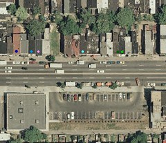 Aerial view of the 1200 block. The Autozone
parking lot is at the bottom of the photo (south side of H Street).
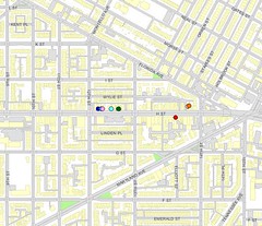
Map of the 1200 and 1300 blocks of H Street NE, Washington, DC.
The dots represent various addresses. GIS is cool. Click through for larger maps.
posted by Richard Layman @ 3:33 PM&Permanent Link
![]()
![]()


0 Comments:
Post a Comment
<< Home