From the archives...
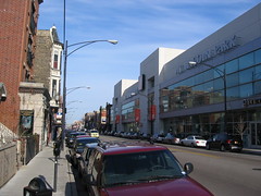 Urban design appropriate Home Depot, Halsted Street, Lincoln Park, Chicago. (Store successfully inserted into the urban fabric.) Photo by Steve Pinkus.
A comment on one of today's blog entries makes me realize that it'd be worth reprinting this document, which was passed by ANC6C and submitted to the Zoning Advisory Committee in 2004. Never heard from the Zoning Commission about any of these suggestions. As I have mentioned in the past, the strategic plan on the Office of Zoning website focuses solely on process, and not on the impact from their decisions on livability and quality of life within the City of Washington.
From October 17th, 2004.
Comments about the impact of Zoning Regulations on Planning and Zoning Issues that impact residents of Advisory Neighborhood Commission 6C
Submitted to ANC6C for consideration and forwarding to the Zoning Advisory Committee for the District of Columbia
The DC Zoning Commission has created a "Zoning Advisory Committee" (ZAC) to receive comments from residents, Advisory Neighborhood Commissions, and other stakeholders about disconnects in Zoning regulations.
ANC6C should recommend a new charge for the Zoning Commission and its companion Board of Zoning Adjustment: "to foster distinctive, mixed-use and mixed-income, appealing neighborhoods and districts with a strong sense of place."
This is an important opportunity to communicate about the very real often negative impacts on livability in the city that the strict application of zoning regulations brings about. Pierre (Peter) L'Enfant designed the city of Washington over 200 years ago to mix residential and commercial uses, and to mix residents of all incomes. Current zoning regulations are counter to these precepts because zoning is designed to keep uses separate, and at times it is also used to separate residents of different incomes levels (such as the restriction on alley dwellings).
There are two basic problems with zoning. Zoning separates rather than blends, although blending is a very natural and human phenomenon. The architect Leon Krier asks "what if you tried "zoning your diet" so you eat vegetables on Monday, potatoes on Tuesday, fats on Wednesday, liquids on Thursday, and fruit on Friday." Do you eat the cheese separate from the pepperoni and separate from the sauce of a pizza? We all know that the pizza is better with all the components blended. Zoning breaks up the pizza that is the city into its parts and separates them.
Urban areas benefit from mixing of uses, spreading out uses throughout the day, and bringing people to the street and stores at different times as well. (This is discussed extensively by Jane Jacobs in Death and Life of Great American Cities in the section on mixed primary uses.)
The second major problem is that the standard zoning code adopted by most states and cities, including Washington, is oriented to suburban building types and styles and to the automobile over the pedestrian. This is 180 degrees opposite of the needs of traditional urban center cities.
Rather than focus on land use, it is important to recognize that "a community's physical form, rather than its land uses, is its most instrinsic and enduring characteristic." (p. 9, from the report Getting to Smart Growth 2.)
Winston Churchill said "we shape buildings and then buildings shape us." All the more reason to be concerned about physical form, about what is created on the land and how it impacts us, rather than a micro-focus on the use of the land.
There are many resources that discuss the principles of quality urban design. They aren't always directly relevant to zoning. But they do key on what's important, and the fact is what's important is usually ignored by zoning laws and regulations. I have included an attachment drawn from "How Can I Find and Help Build a Walkable Community" by Dan Burden. Note that he lists Washington, DC as a premier walkable community. It is our charge as residents of this great city to maintain and extend this legacy.
(Another good source is the paper "Principles of True Urbanism.")
For this discussion, I have relied on two reports, Getting to Smart Growth (abbreviated GTSG1) and the follow up report Getting to Smart Growth 2 (GTSG2). These reports were produced by the Smart Growth Network, the International City-County Management Association, and the US Environmental Protection Agency, and they make a number of suggestions for improving center cities that are relevant to the request of the Zoning Advisory Committee for feedback on current laws and regulations. (There are many other points that are relevant to planning issues generally, but not to Zoning.)
I have drawn out a number of points from the two reports, and recommend that ANC6C forward these comments on to the Zoning Advisory Committee as endorsed recommendations by the Commission.
These points are particularly relevant to those of us living and working in ANC6C, which include neighborhood commercial districts and part of the central business district (Downtown) as well as historic and newer residential areas in both the NW and NE quadrants. Some of these neighborhoods face major development pressures and the possibility of conversion to commercial use as Downtown continues to expand eastward from Downtown and the Convention Center.
---------------------
Adopt comprehensive plans and sub-area plans that encourage a mix of land uses (p. 2, GTSG2). While this requires a change in the comprehensive plan for the city, a process that is underway, sub-area plans (called small area plans by the Office of Planning) and overlays, including transit oriented development, are increasingly calling for mixed uses. Small area plans and overlays continue to be submitted to the Zoning Commission for consideration and adoption in the meantime. The Zoning Commission needs to reconsider regulations that strictly separate uses. Neighborhood retail uses not in standard commercial districts ought to be selectively encouraged (such as corner stores and cafes) as should alley residential dwellings and other types of units that can expand the currently shrinking stock of affordable rental housing in the center city.
The more uses are mixed, particularly with housing in close proximity to employment centers, will yield a great number of public policy benefits including the greater utilization of the public transportation infrastructure, the reduction of car trips, increased pedestrian activity, and greater public safety.
Display zoning regulations and design goals in pictorial fashion to better illustrate development goals (p. 74, GTSG1). Depicting outcomes that are visual in nature through the written word can be a challenge. Zoning regulations are dense statistical documents, difficult to understand, appear conflicting, and sometimes vague. Faced with uncertainty, developers will often resort to what they know they can build. The result is development that is familiar and conventional and less like to be innovative. By changing to a guide of "zoning by showing" pictures can help convey to developers, architects, and builders the precise types of developments that communities desire. (One example is the attachment from the Portland, Oregon Pedestrian Design Guidelines manual.)
Use enhanced zoning techniques to achieve a mix of land uses (p. 3, GTSG2). Many cities base planning and development on outdated and antiquated zoning ordinances that are revised piecemeal rather than comprehensively. Many communities are adopting new methods to regulate land use. What joins these different approaches is a focus on form and design, rather than permitted and nonpermitted uses. Examples include "form-based coding" (recently adopted for Columbia Pike in Arlington County), performance incentives, and new types of overlays that call for mixing of use and quality design as a matter of course.
Match building scale to street type in zoning and permit approval processes (p. 12, GTSG1). Communities can highlight more opportunities for compact building design by creating stronger links between street width and building scale. People feel more comfortable in neighborhoods in which buildings and landscape properly frame the street area. In clearly defining this balance between street type and building scale, a community can encourage more compact communities and, as a result, can better absorb new growth and development.
Revise zoning and building codes to permit a wider variety of housing types (p. 19, GTSG1). Lot size and coverage standards, among others, are not suited to helping communities add to the housing stock, the supply of rental housing, and to expand the range of housing choices. If these issues are addressed adequately, housing can more easily meet the needs of a diverse and changing population.
Encourage the redevelopment of single uses into mixed-use developments (p. 5, GTSG2). We are all aware of the dead zones in our city, not just in downtown, many parts of which shut down after 5 pm, but in areas throughout the city. These single-use districts are the intended result of current zoning regulations and development patterns. By retrofitting such districts, such as the nearby Florida Avenue Market, or the areas around subway stations, we have an opportunity to make better use of infrastructure, increase the value of the investments, and provide more convenience to residents and workers, and to increase the vitality and safety of these areas by providing activity and use throughout the day and night.
Selectively locate neighborhood stores in residential areas (p.6, GTSG2). Before zoning, neighborhoods had corner groceries and drugstores and even cafes. Suburban outmigration and changes in retail practices made such uses obsolete for many years. However, as residents return to the city, these types of uses can be viable once again and will add vitality and convenience to residents. But these commercial uses are forbidden under current zoning, with the exception of those businesses that have remained active. This needs to change, however it must balance community interests and preferences with business interests, and ensure that public space is not encroached upon for storage and waste management by such businesses.
Make retail centers attractive and distinctive destinations (p. 48, GTSG2). Creating attractive retail is a viable business strategy for developers and a boon for the residents and consumers who shop there. The project becomes more than just a place to buy goods: it can become a centerpiece for the community. It is ironic that developers that have created projects such as Bethesda Row in Maryland, or the Villages at Shirlington in Virginia use the best principles of urban design and the urban experience to strengthen the suburban retail experience at the expense of the city. Meanwhile, urban developers are often aggressively suburbanizing neighborhood commercial districts with automobile-centric developments and/or buildings that violate traditional and standard precepts of successful retail architecture and design and homogenize what would otherwise be a unique retail and entertainment experience. Zoning regulations should be changed to prevent this.
Organize a variety of land uses vertically and horizontally (p.8, GTSG2). Sometimes the most effective mix of uses occurs within the same building. Noise can be a problem for housing in mixed-use districts, particularly at the street level. By encouraging streetlevel retail, second- and third-story offices, and residential development on top levels. This is important particularly at nodes or key intersections, where in many (but not all) cases, larger, mixed-use buildings, can be appropriately sited without deleterious impacts on the surrounding community.
Create a pedestrian master plan (p. 32, GTSG2). The plan may include model codes and ordinances, technical guidelines, estimated project costs, public transit and automobile traffic coordination, and land acquisition and growth issues. With regard to zoning, it is particularly important that the construction of blank walls be forbidden on those elevations that face the street. Portland Oregon provides a model plan which provides excellent guidance for how to link zoning and building regulations to strengthen walkability and the primacy of the pedestrian. I have attached a drawing from page 4 of this publication.
Situate parking to enhance the pedestrian environment and facilitate access between destinations (p. 37, GTSG2). Parking lot design may force pedestrians to take unsafe routes between parked and moving cars to reach nearby destinations. The design of large surface parking lots in urban centers may cause pedestrians to walk further to access otherwise adjacent buildings. Large parking areas located in front of buildings separate pedestrian traffic from businesses and leave walkers isolated in an unappealing environment.
Require building design that makes commercial areas more walkable (p. 28, GTSG1) Diverse streetscapes with retail shops, offices, public facilities, and other nonresidential uses are destinations as well as community assets. A lively and inviting street is viewed as safe and attractive, whereas an empty street, void of pedestrian activity, conveys abandonment or danger. Building aspects that isolate people and discourage pedestrian activity include "faceless" buildings without windows or doors at eye level, buildings with no first-floor retail, or buildings that are set back a great distance from the street. Increasing pedestrian traffic in these areas requires that buildings incorporate designs that create a sense of place and security.
Ensure that big box stores locating in existing urban centers are appropriately scaled and designed (p. 16, GTSG2). Big box stores, which typically range in size from 90,000 to 250,000 square feet, are popular shopping destinations for American consumers. Architecturally, these stores are typically characterized by windowless, standardized, one-story buildings with an ample supply of parking—hence the moniker “big box.” But it is important to ensure that upon entering urban areas, that these buildings respect the urban form, rather than aggressively suburbanize it.
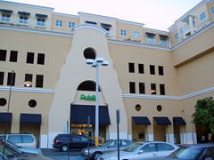 Publix Supermarket with structured parking and housing, Douglas Grand, Coral Gables, Florida. Photo from Urban Planet.
Brentwood is a case in point. Across the country, many large stores such as supermarkets, are being built in mixed-use settings, where housing is built on upper levels of the site, rather than settling for a one-story sprawling building. Greenfield bix boxes should be encouraged through changes in zoning to seek compact designs, incorporating multi-story buildings that respect the urban form, street, and pedestrian- centricity.
This means:
• prohibiting blank walls;
• make parking urban not suburban, by requiring parking in structures or behind buildings;
• All facades of a building that are visible from adjoining properties or public streets should contribute to the pleasing scale features of the building and encourage community integration by featuring characteristics similar to a front facade.
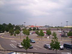 Suburban style shopping center inserted into DC. This space was not urban, but it is adjacent to a subway station and site planning could have begun a revitalization process for the area based on extending the urbanity south from Rhode Island Avenue.
 Index Keywords: urban-design-placemaking
posted by Richard Layman @ 5:43 PM&Permanent Link
![]()
![]()


0 Comments:
Post a Comment
<< Home