Bus maps and congestion charges

(AP Photo/Lefteris Pitarakis)
While I do favor charging somehow people who come into the cities by car, I think that in the U.S., getting something comparable to the Congestion Charge assessed in London is almost politically impossible, except maybe in NYC.
But one thing the Congestion Charge has done in London, by reducing traffic overall, surface bus routes move more quickly.
This is from the NewMobilityCare e-list, and written by Steve Cousins:
Today the London congestion charge zone expanded but in a climate of UK wide 'Motorist' anxiety.
However, motorists who feel aggrieved by the extension of the London charging zone have some positive assistance this week with the launch of a new easy-to-read one page bus map for London. It is produced by designers David Sherriff and Andrew Sutton and shows both the new and the old charge zones and the areas around them. The press and the publicity for the zone extension has majored on the 'legals' which has made it all feel a bit oppressive and negative. Instead we could have had all the positive messages. Really it’s a DEcongestion zone, freeing up the city for walking, faster buses, and just better breathing all round. For the £8 million publicity budget (according to the London papers) we could have seen some really positive posters and leaflets showing the benefits for London. Check out "London by bus" and the buses that are liberated at Quickmaps. Every big city needs a map like this!
The Quickmaps look pretty interesting. I guess I'll have to buy them at some point. Although one thing that the MTA does for the Baltimore region is provide a similar kind of pocket map that is made available for free.
But this Quickmap online "bus movie" showing bus routes from the Liverpool subway (tube) station is incredible. Check it out.
The London bus route maps produced by Transport for London are also quite good, somewhat comparable to the maps that WMATA has been rolling out at bus stops at subway stations.
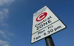
Photo source unknown.
Labels: transit
posted by Richard Layman @ 10:15 AM&Permanent Link
![]()
![]()


0 Comments:
Post a Comment
<< Home