Mapping new mobility
As has been discussed here from time to time, we are working on some "proof of concept" signage for consideration in terms of extending the wayfinding signage system in Washington, DC. Christopher Taylor Edwards of This is None: Storytelling by Design is the designer for the project.
- Florida Market Map & Directory
- Florida Market History Sign
The first iteration of the sign had a significant breakthrough by using graphic elements from the regional transit subway and bus maps to depict these services. (Most non-transit maps use railroad tracks and other identifiers.)
While this sign included information on the forthcoming bicycle trail along the subway/railroad tracks, it was pointed out to us by Washcycle that the sign didn't include other information on bicycle accommodations.
In keeping with our use of graphic elements from transit maps, we decided to respond by incorporating the graphic elements depicting bicycle trails and routes from the DC Bicycle Map published by the DC Department of Transportation. (Although we also reviewed other bicycle maps published in the region.)
But this map didn't provide the guidance we needed in terms of providing symbols for depicting locations for bicycle parking, compressed air for tires, and bicycle sharing stations. We looked to other maps such as San Francisco and Melbourne (both excellent, and the Melbourne map has great and well laid information on cycling rules, safety and related issues).
We wanted to use icons without words, which is the way that maps try to depict things, with universal symbols, but we were stymied. Instead we did this:
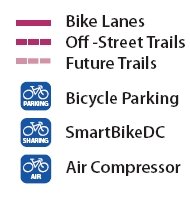
And we would extend this concept with additional logos for Stores, Stations (Bicycle Station), and Rental, although no establishments offering such services happen to be located in the area covered by this particular map sign.
Any comments are welcome.
(The map side of the sign is being extended a bit, to 1st Street NE on the west and M Street NE on the south. That is the other part of this set of changes.)
Labels: bicycling, wayfinding
posted by Richard Layman @ 10:04 AM&Permanent Link
![]()
![]()


0 Comments:
Post a Comment
<< Home