A transportation infrastructure stimulus plan for DC and the region

Internet photo of highway planners at the state and local level.
Right now, state governors and big city mayors are chomping at the bit to get all their projects considered as part of the infrastructure stimulus plan proposed by President-Elect Obama. Sadly, most of the projects are for roads.
See "Stimulus Package To First Pay for Routine Repairs" from yesterday's Post. and this from a couple weeks ago, "States Want $176 Billion Slice of Stimulus: Governors to Ask Obama to Set Aside Federal Funds" as well as stuff I wrote about last week. Don't you love this, from yesterday's article...
Most of the infrastructure spending being proposed for the massive stimulus package that Obama and congressional Democrats are readying, however, is not exactly the stuff of history, but destined for routine projects that have been on the to-do lists of state highway departments for years. Oklahoma wants to repave stretches of Interstates 35 and 40 and build "cable barriers" to keep wayward cars from crossing medians. New Jersey wants to repaint 88 bridges and restore Route 35 from Toms River to Mantoloking. Scottsdale, Ariz., wants to widen 1.5 miles of Scottsdale Road.
It's not that I am completely against roads or driving. I drive cars, and I use roads as a car driver, a pedestrian, and a bicyclist.
But I believe that the number one priority for the United States should be to rebalance its mobility program towards optimal mobility and complementary land use policies. This means moving away from private automobility and towards transit and walkable-bikable communities.
This will reduce oil use considerably, which will have many positive effects on the U.S. economy, the federal budget, and foreign policy, as well as positive impacts on individual/household wealth.

Or another way to think about this would be Robert Puentes of the Brookings Institution's point that we should make a national priority of having 25% of work trips in the top 50 U.S. metropolitan regions being conducted by transit, walking, and bicycling, and stating infrastructure development priorities and funding accordingly.
So here is my proposal for the Washington DC Metropolitan Region, recognizing that some of the suggestions go beyond the immediate Metropolitan region. Note that this is in keeping with the findings in NYC about how their recent growth has been accommodated by transit rather than automobility. See "New York’s Boom Saw More Jobs and Residents, but Not More Cars" from yesterday's New York Times. Anecdotally, I think this is mostly true for DC proper, with some exceptions, such as New York Avenue.
Multi-state regional improvements
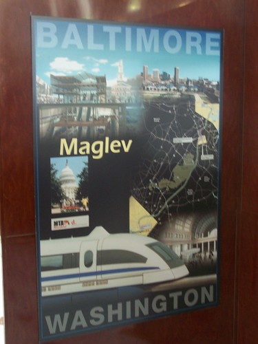
1. Maglev railroad system from Boston to Norfolk, serving New York City, Philadelphia, maybe Wilmington, Baltimore, DC, and Richmond along the way. See the Baltimore-Washington Maglev Project website.
2. A 24/7/365 regional passenger railroad system (think of how service is provided by railroads in the NYC, Boston, and Philadelphia regions) serving DC, Maryland, and Virginia primarily, with secondary service provided to parts of West Virginia, Delaware, and Pennsylvania. I call this the "Railroad Authority of the Chesapeake Region" or RACER. This includes and extends the programs for service expansion as proposed by Maryland's MTA and the Virginia Department of Rail and Transit.
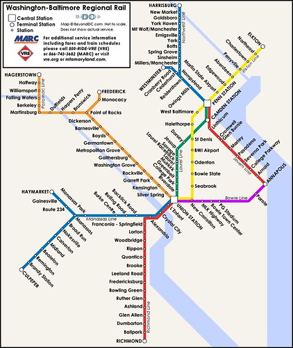
Earlier iteration of a proposed regional railroad system produced by Dan Malouff of BeyondDC. This map doesn't show the full extent of a possible system as proposed by this document.
Metropolitan Washington regional improvements
3. Full funding of WMATA capital improvements (see "WMATA's 10 Year, $11B Capital Plan" from the Infosnack Headquarters blog).
4. Full funding of a complete circumferential "Purple Line," not just the portion from Bethesda to New Carrollton.

Sierra Club image.
5. Recast the "Silver Line" subway extension beyond its Virginia confines, and extend this line into DC with a separate tunnel crossing and as what was once termed the separated blue line in WMATA planning. This will add capacity at the core of the city which has regional ramifications, as well as more stations within DC neighborhoods, which has intra-city ramifications.

WMATA's original proposal for a separated blue line, from the Washington Post, 2002, image not available online. Provided by the courtesy of Lyndsay Layton, the journalist who wrote the story.
6. Develop regional planning for surface-based transit improvements, particularly of fixed-rail, which has proven to be effective in many dimensions in the Washington region. And build the system that results from the planning.
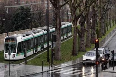
Paris has added surface based fixed rail, which they call tram, to their array of subway and railroad services. The DC region needs to take the next step and do regional transportation planning. Paris has the greatest subway station density of any major city in the world. Plus it has more railroad service and stations throughout the city than most other cities also. Photo: Reuters.
What I mean by this is separating out light rail from streetcars, and looking at having some light rail lines which have regional implications, and focusing streetcars within jurisdictions. For example, a light rail line from Dupont Circle out Rhode Island Avenue and US Route 1 to as far as Laurel would have great positive impacts for DC and Prince Georges County, Maryland. Similarly, perhaps a light rail line could serve Georgia Avenue in DC as well as Colesville Road/Route 29 in Montgomery County. And, I think that the H Street-Georgetown-Rosslyn streetcar line could maybe be a light rail line too, depending on how it could be extended into Prince Georges County.
I am not knowledgeable enough about the needs in Northern Virginia, but I imagine that there are similar opportunities, and more in Maryland's suburbs too, beyond the ones I've suggested.
DC infrastructure improvements
7. Fund the separated blue line subway as listed above in #5.
8. Consider the development of a mostly intra-city "brown line" as suggested by Michael S. earlier in the year. See "Michael's proposed Brown Line." Note that the line as proposed in that entry is different from the one below, which was tweaked based on reader comments to provide more service to other parts of the city, as well as to add parallel capacity to parts of the red line.

This map, graciously produced by David Alpert of Greater Greater Washington, shows a separated blue line as silver, the proposed brown line, as well as the current extent of planning for the Purple Line.
9. Fund streetcar development within the city, with the proviso that surface fixed rail be planned in a manner that acknowledges regional implications and provides appropriate connections accordingly. See "Streetcar Plan Has Money and Desire" and "Streetcars in DC's Future - Get There" from the Post.
The maximum extent of DC's streetcar planning as evidenced by this map from the DC Alternatives Analysis from 2004. It's not enough to just plan within DC, we need to plan for connections beyond DC, and plan for heavier service where potential demand warrants.
10. (This is a road project.) Figure out how to interdict inter-state traffic on New York Avenue connecting to I-395 continuing to Virginia. This can include surface rail but probably should also include a tunnel from the DC-MD line on Route 50 to underneath K Street NW as partially proposed by the New York Avenue Corridor Study by the DC Department of Transportation. (They didn't propose a full tunnel because of the cost. Here we are saying "cost be damned.")
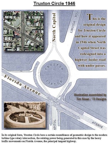
11. Speaking of "complete places" planning, fund at least 3 "neighborhood repair" projects such as Tim Sloan's proposal to restore Truxton Circle at the intersection of North Capitol Street and Florida Avenue. See "fixing the intersection of florida and r" from Bloomingdale (for now).
Crazy Hard and Expensive Proposal
12. If you really want to spend money on infrastructure....
a. put the CSX Metropolitan Branch railroad underground.
b. There would have to be at least two levels of tunnel, for both the railroad -- three tracks -- and for the subway.
c. Make the subway tunnel two levels, or capable of carrying doublestack trains to double the capacity of the red line subway.
This one is so expensive that I won't put it in the priority list, but it could be done and would impact the region's and especially the city's competitive advantage for generations. See the blog entry, "Rethinking the Metropolitan branch railroad and subway tracks in northeast DC" for much more about this.
Creating a complete Regional-Metropolitan DC transportation infrastructure stimulus plan
A full plan would require the addition of sections comparable to the DC section for Northern Virginia and for DC's Maryland suburbs, and for the Baltimore region. (I lack the detailed knowledge of those areas to confidently write a full list of suggestions.)
All of this would cost at least $20 to $30 billion, which is $10 billion to $20 billion more than the highway proposals for the State of Utah, but would have far more day to day impact as well as economic impact lasting generations.
Labels: infrastructure, transportation planning
posted by Richard Layman @ 10:37 AM&Permanent Link
![]()
![]()


0 Comments:
Post a Comment
<< Home