K Street Transitway comments accepted until October 30th
See the DC Dept. of Transportation website: REMINDER: K Street Environmental Assessment (EA) Comments Due.
- K Street Transitway Environmental Assessment
I like Alternative 3 because of the inclusion of bikeways. It's more of a "complete street" design and we need prominent examples of dedicated bike facilities in the city, especially Downtown-- why not on K Street? But Alternative 2 is a flexible alternative where the curb lane could be an additional bus-only lane in rush hour for instance.
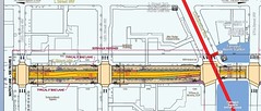
In either Alternative 2 or 3, optimizing how space is used from the face of the buildings on either side of the street, including the sidewalks, parking and service lane, side medians, and the through streets more optimally serves more people "more better."
What it will do is move transit along more quickly, provides for better vehicle throughput, and if constructed properly, as good if not better experience on the street for pedestrians (note that the K Street and Connecticut Avenue intersection is probably the #1 intersection in the city in terms of the volume of crossings Monday through Friday), and ultimately, for the ground floor businesses as well.
At the expense of some onstreet parking.
The real question here is about "prioritization," throughput, and optimality. And what it makes sense to focus upon, and upon what criteria it makes sense to use in coming to a decision.
The Thomas Jefferson Planning District in Albemarle County, Virginia has a nice illustration of what it means to focus on optimality, in their Street Capacity Demonstration (although they should have included one shot of a bus with 40 passengers too). It's similar to the graphics produced in Berlin, Tampa, and elsewhere called "packing the pavement."
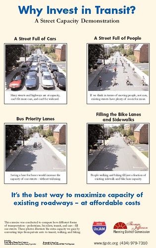
From a throughput standpoint, it makes sense to prioritize transit and the through lanes, and to be less concerned about providing a limited amount of parking spaces on the street--note that a DDOT official says there are about 300 on street parking spaces on K St. in the impacted area, and more than 15,000 spaces in parking garages and/or on-street within one block of either side (L or I Streets) of K Street.
Or as Abraham Lincoln is alleged to have said in the famous case where he represented the railroads that wanted to build a bridge over the Mississippi River vs. the riverboat interests which opposed the bridge: which interests are more important, traveling up and down the river or crossing the river?
Throughput and mobility optimality should be seen as the most important goal and objective, rather than the more narrow objective of maintaining parking on K Street.
The goal is extending the qualities of the livable city and continuing to improve DC's competitive advantages around transit efficiency.
E.g., look what is being proposed for the "42nd Street Transitway" in Manhattan--no cars. See "A Quieter, Calmer (and Car Free) 42nd Street" from Wired about the proposal from the Institute for Rational Urban Mobility about what they call vision42 and "Making New York's 42nd St. a Different Sort of Thoroughfare" from the New York Times.

Illustration: Mathieu Delorme.
Remember that ultimately, the K Street transitway is also supposed to support streetcar service from Minnesota Avenue, along H Street NE, to Union Station, along K Street in NoMA, Mount Vernon Triangle, and Downtown, to Georgetown (and probably with a connection to the Rosslyn Metro and a turnaround there--just like the old days).
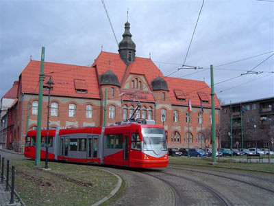
DC Streetcar being tested in the Czech Republic.
A couple weeks ago I went to a fabulous presentation about transportation demand management programming in Arlington County. (I went to four conferences/presentations in two weeks, plus an exhibit in Philadelphia on a Saturday. That plus work and commuting means I haven't written up any of them.)
But I was thinking that while Arlington does site planning for transportation demand management, and Alexandria has hired an Arlington staffer to do the same thing, we really need to have a "parking planner" assigned to deal with parking optimization in the Central Business District.
Of course, really what we need is a "transportation management district" to manage optimality and throughput overall, rather than a strict focus on parking (a "parking management district").
But even so, to best use the parking resources available along K Street, parking information systems, wayfinding, and management of the available resources must be coordinated (with suasion and legal requirements if needed) in order to reap the full benefits of the extant resources.
I'd rather see a focus on that, than on concerns about the loss of a minimal amount of parking.
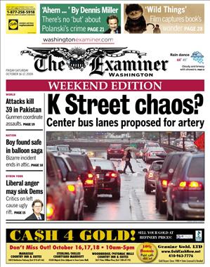
The real chaos is in promoting suboptimal transportation decisions, which seems to be the position of the Washington Examiner, judging by their recent choice of words on the cover of the 10/16/2009 issue.
Labels: fixed rail transit service, transit, transit and economic development, transportation demand management, transportation planning, transportation supply management, urban design/placemaking
posted by Richard Layman @ 10:34 AM&Permanent Link
![]()
![]()


0 Comments:
Post a Comment
<< Home