Public squares and DC
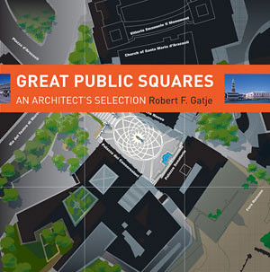
Both the Washington Post ("Where is Washington's great public square?" by Philip Kennicott) and the City Paper ("Is There Hope for D.C.’s Public Squares?" in Housing Complex) beat me to discussing Robert Gatje's book (and presentation yesterday at the National Building Museum), Great Public Squares: An Architect's Selection.
The material in the book and the presentation is short in terms of laying out the overarching principles of what makes successful squares. Most of the book and the presentation describes the public squares that Gatje thinks are some of the greatest in the world.
I didn't take many notes on the talk, only about 100 words. But these were some of the conclusions I came to, whether or not Gatje said them specifically:
- density
- crossroads and places that are connected (Gatje)
- people want to be there (Gatje)
- outside living - outdoor rooms
- integration of civic life and commerce.
The book text has short descriptions of major features including dimension, height, the facade wall/enclosure and materials, roadways, pavement materials, street furniture, the presence of arcades (covered walkways), monumental buildings and features, trees, and pedestrians/people.
The descriptions of the various successful squares showed common themes of success such as the presence of public buildings (town halls), churches, schools, commercial buildings, and housing located as part of the greater square area and on the perimeter of the square, providing a sense of enclosure but also connectedness, vitality, and integration.
Gatje didn't discuss very deeply the connection between the development of public squares and public markets--where farmers came into the city to sell foodstuffs to residents in the time when retail shops didn't exist, not to mention refrigeration, which required daily shopping.
If you look at the public squares and parks in DC that for the most part fail, it is because they are disconnected places, and that they are rarely places where commerce is allowed to be integrated--the National Park Service, which controls many of the public squares and circles in DC, has strict regulations against commerce, unlike similar but wildly successful parks in other cities such as the borough of Manhattan in New York City, Schenley Plaza in Pittsburgh, the Navy Pier in Chicago, and Campius Martius in Detroit.
Frankly, when it comes to the value of place and placemaking in public squares, the work of the Project for Public Spaces, or the wisdom expressed in the tome Creating a Vibrant City Center by Cy Paumier is more applicable, even though Mr. Gatje's book will be a great resource for city planners and involved citizens seeking inspiration.
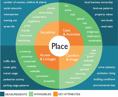
PPS Place Making Diagram
Resources from the Project for Public Spaces
One of the points in my seemingly ignored New Year's blog entry ("New years post #5: DC City Council Committees and striving to be a world class city") laying out a potential agenda for each of the DC City Council Committees, was this point, with regard to the Committee on Public Works and Transportation:
Extend Councilmember Wells' efforts as Ward 6 Councilmember focused on placemaking and quality of life improvements in Ward 6 to the development of a citywide placemaking and quality of life improvement effort. (Note that DDOT's streetscape planning and construction efforts under Dan Tangherlini around 2000 are the foundation and first building block of this effort.)
It is important to take this up generally, but it shouldn't be focused on what we might call high art, which is what Kennicott is is focused on, and the creation of an absolutely great single square in DC.
Although years ago I thought that DC should have done the equivalent of Chicago's Millennium Park on the Old Convention Center site, which instead is mostly going to be big buildings with commercial and residential space. A separate blue ribbon task force recommended including a great public space and civic functions on the Old Convention Center site, but for the most part this won't be happening, which is one of the disappointments I do have with Mayor Williams and then planning director Andrew Altman.
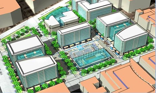
Concept for a public square on the Old Convention Center site, Cy Paumier.
Instead, a placemaking agenda should focus on making great places throughout the city, not just Downtown or in the federal city such as along the National Mall, using the urban design and placemaking principles that are known but too often ignored (by the National Park Service especially).
One of the initiatives that should be included as part of such an agenda would be the restoration, creation, and extension of public squares throughout the city through improvements in the placemaking qualities of "traffic" circles, such as Dan Malouff's proposal to create Scott Square ("Let’s convert Scott Circle into Scott Square" from BeyondDC), past efforts concerning Truxton Circle ("the case for bringing back truxton circle" from Bloomingdale (for now), and others (I am thinking of one at Georgia and Missouri Avenues as a way to fix the traffic problem at that intersection and recenter commercial development on that node of Georgia Avenue).
DC has done a circle restoration at Thomas Circle, during the Williams Administration. I don't know the details, but in 1950, DC's Logan Circle was reduced in size for the addition of roads. From 1982-1985, the original dimensions were restored.
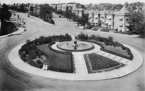
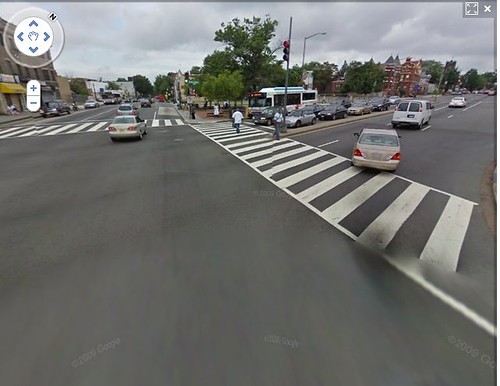
Truxton Circle before and after. The Circle was named after Revolutionary War commodore Thomas Truxtun (1755-1822), whose estate was later granted to the District. Until 1940, Truxton Circle was located at the intersection of Florida Avenue and North Capitol Street. First image: Library of Congress. Second image: Google Street View.
Truxton Circle before and after. The Circle was named after Revolutionary War commodore Thomas Truxtun (1755-1822), whose estate was later granted to the District. Until 1940, Truxton Circle was located at the intersection of Florida Avenue and North Capitol Street. First image: Library of Congress. Second image: Google Street View.
I was not able to attend Cy Paumier's presentation at the National Building Museum in October, Creating Great Places: A Vision for Washington, D.C.'s Center City Public Realm," which was part of the Smart Growth Speaker Series. Paumier presented specific proposals for improving the 12 most important public spaces in Washington D.C.’s center city.
Fortunately his talk and presentation is online.
His presentation focused more on the monumental, high art kinds of spaces across the city, particularly in the federal city, although not completely.
He discussed the concept of a high quality, integrated public realm, not unlike David Barth, who I frequently tout as one of the nation's best parks planners. Maybe that's the way this Council Committee agenda item should be termed, on refocusing the transportation towards the creation of a high quality public realm across the city. Note that is happening already, with DDOT's streetscape initiative, streetcar planning, and other initiatives. But it still needs a scalar change and upgrade into a more all encompassing program.
From the Paumier presentation.
Labels: parks, urban design/placemaking
posted by Richard Layman @ 10:35 AM&Permanent Link
![]()
![]()


0 Comments:
Post a Comment
<< Home