1964 Esso road map of London shows subway map
I think this road map is interesting, because it includes a map of the London Underground, London's subway system. I've checked Esso maps from around the same period for Boston and New York City and the road maps don't include a map of the subway. Granted, at least for NYC, they've always made subway maps widely available, so maybe there wasn't the same level of need.
The current Washington area map from the American Automobile Association does show the area subway map, but I haven't looked at earlier editions. Around when the DC subway system became operative, gasoline station companies stopped making private labeled maps, instead shifting to the sale of maps branded by the producer, such as Rand McNally.
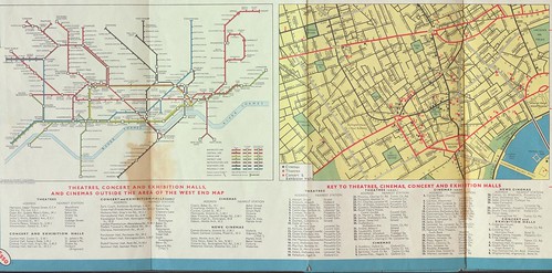
This section of the map sadly has a bit of discoloration. Then again another copy I have of the map has holes, so this is better.
I came across this map as part of a grouping of maps, which I bought mostly for an old Esso map of Heathrow Airport, which is interesting because it shows plans and how aviation gasoline is stored and transported to airplanes--I am interested in how "road maps" were used by oil companies to communicate non-standard information so some maps I have along these lines include:
- a boat cruising map of Ontario (and another in England, but I haven't yet managed to snag a copy of a River Thames Esso map)
- a Conoco map of Yellowstone National Park
- an Esso map for the 350th anniversary of Williamsburg, Virginia (remember that the Rockefeller Family, which still owns a lot of Exxon stock, funded much of the creation of the historical park at Williamsburg)
- the London Heathrow Airport Map
- lots of pictorial-tourism promoting map styles (Esso did this in the 1940s and 1950s especially; Gulf too)
- a map of the Presidential election process
- a bunch of cool Esso maps on heritage trails, the Civil War, etc. (they also have maps of WWII battles, but I haven't been too interested in that stuff)
Labels: tourism, transit marketing, wayfinding
posted by Richard Layman @ 11:54 AM&Permanent Link
![]()
![]()


1 Comments:
Thank you for a very informative articles.
Post a Comment
<< Home