Seattle's launch of bike share and four interesting elements

University of Washington students can get a discount on annual memberships. Images from Geekwire unless otherwise specified.
See "My first bike-sharing ride in Seattle was lots of fun — but not without some speed bumps" from Geekwire for real-life experiences using the Pronto Bicycle Sharing system in Seattle.
The system is run by a nonprofit, and Alaska Airlines is the title sponsor, having paid $2.5 million for a 5-year deal (press release). Although it's only supposed to get them branding on the first 500 bikes, so I guess as the system expands they can add other sponsors. (One of the criticisms of the Barclays sponsorship in London was that they didn't pay more as they got more branding opportunities as the system expanded.)
At this point, the stations are primarily located in the core of the city, on the east side, where population of the city is centered. The City Government has committed some dollars to an expansion. The launch was with 50 stations and 500 bikes. The intent is to grow the system to more than 200 stations and 2,200+ bicycles.

Different bike from other Alta-run systems. While Pronto is run by Alta Bike Share they aren't using the same "Bixi" bikes used in other systems in places like Boston, Minneapolis, New York City, and Washington, due to the fallout of the bankruptcy of the original company out of Montreal, its purchase and the subsequent abrogation of the contracts with the US-based systems.
The bike is still manufactured in Quebec, by Arcade bicycles and is a bit lighter than the model in other cities. Plus the bike has seven gears, while most of the Bixi systems have three-gear bikes. (Seattle has some serious hills, not unlike San Francisco.)

In Melbourne and Brisbane, Australia, helmet requirements have hindered the use of bike sharing systems and by comparison to cities in Western Europe and North America, bike sharing has been a massive failure.
It's an $81 ticket for not wearing a helmet in Seattle. A "cabinet" with helmets is located next to each station (pictured at left) and it costs $2/day to use a helmet, although right now use is free. Returned helmets are supposed to be cleaned before being reused.

Group/neighborhood bike rides as a promotional technique. Like I used to suggest in writings and RFP responses, as an outreach and marketing tool, the system is sponsoring neighborhood bike rides as a way to introduce the Pronto system to riders and neighborhoods.

That's something I haven't thought of mapping for the public outside of plans in quite the same way, although it has been done, for example in the publication by VeloQuebec. It would be a useful element to add to my "mobility shed" concept.
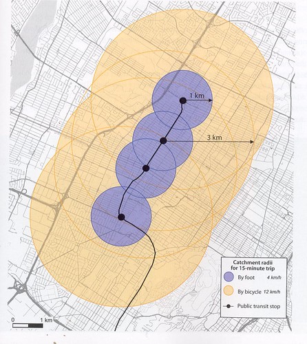
Catchment area of public transit stops for pedestrians and cyclists from Planning and Design for Pedestrians and Cyclists: A Technical Guide. (I've used this image before in presentations.)
Labels: bicycle and pedestrian planning, bicycle sharing, transportation planning, urban design/placemaking
posted by Richard Layman @ 6:20 PM&Permanent Link
![]()
![]()


4 Comments:
Good write up.
The station maps that CABI has put up are getting useless -- way too much density and you can't really figure out where a station is.
It would not be hard to figure out the top 10 destinations for each station and put up the best bike route there. I understand that 95% of users are using smartphone but actually in DC a large part of international users are not because of data issues.
Likewise, Citibike in NYC has its own app.
Anything on the docks themselves?
Personally, I prefer maps because I have a slow old phone and a weak battery that has to be constantly recharged.
Your idea of route mapping is interesting.
2. good question about docks. They are different too. I haven't checked to see who manufactured them. I don't know if they would be interoperable with standard "Bixi" bikes.
For an image:
http://www.seattle.gov/transportation/bikeshare.htm
Arlington issues a statement clarifying that Alta has a "new dock design" that is compatible.
Looking at the pictures, the metal tongue on the bike looks very similar, althoughit sticks out more than the BIXI ones.
Wow, what an amazing information!! Thanks so much.
Post a Comment
<< Home