"Utility" infrastructure as an opportunity for co-locating urban design and placemaking improvements
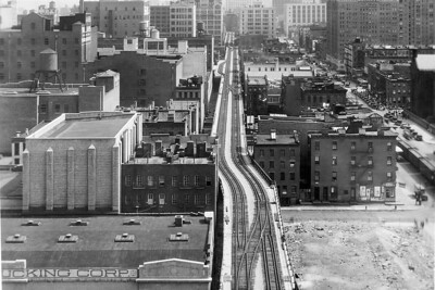
Often utility corridors may be one of the only opportunities to create trails and pathways in places where private property rules. It was frustrating when I worked a bike and pedestrian plan for Baltimore County, because there wasn't a good way to create a dedicated pathway between Baltimore City and the county center in Towson.

Image: Friends of the Washington and Old Dominion Trail.
To me, given it was the only option, I didn't think we had that luxury. Although I lost on that one, surprisingly the utility company was willing to consider it. (Another similar missed opportunity was a utility and stormwater piping corridor along the Patapsco River.)
One of my arguments is that providing a regular use within the corridor could add to security, providing "more eyes on the street."
This was a few years before an attack on an electricity substation in California ("Sniper attack on California power grid may have been 'an insider,' DHS says," CNN).
The Perils for Pedestrians public access television program has an episode, "Gallery of Power Line Right of Way Trails," featuring 26 (!) different examples including in the DC area.
Transformational Projects Action Planning. From the standpoint of what I call TPAP, harvesting opportunities for urban design and placemaking improvements simultaneously with the development of other infrastructure ought to be a no brainer.
-- "Why can't the "Bilbao Effect" be reproduced? | Bilbao as an example of Transformational Projects Action Planning"
This could also be a key element of "Green New Deal" planning.
Transportation Infrastructure as an Element of Civic Architecture. Before TPAP, I wrote about "transportation infrastructure as an element of civic architecture."
-- "Transit, stations, and placemaking: stations as entrypoints into neighborhoods," 2013
-- "Transportation infrastructure as a key element of civic architecture/economic revitalization #1: the NoMA Metrorail Station," 2016

One of the pioneers was the Boston & Albany Railroad, which invested in railroad stations--designed by H.H. Richardson and plantings--by Frederick Law Olmsted--as an element of marketing.

-- Rails to Trails Conservancy
The problem with this is that use as a trail builds a constituency to keep it as a trail and not as a transit corridor.
This has been an issue wrt the Purple Line light rail project in Suburban Maryland, and the organization Friends of The Capital Crescent Trail | Save the Trail!, although partly many of the members, homeowners along the line with their backyards abutting the trail, were more more interested in not having a frequent transit line there.
This also comes up with "temporary" park uses for lots not ready to be developed. See "Predictable outcome: people want to make a temporary park permanent."
It's why developers prefer to keep the space vacant. (It's a similar phenomenon when people reside in industrial-manufacturing areas, like the "Meatpacking" District in NYC, or in farm-adjacent lands in suburbanizing rural areas.)
 But there is a rise of incorporating trails as part of existing or new rail transit projects, including the SMART rail project in Sonoma and Marin Counties in California, trails alongside the Expo Line in Los Angeles, and the Purple Line.
Elliott Bay Trail. Photo: Green Lane Project credit Adam Coppola Photography.
In Seattle, part of the Elliott Bay Trail in the city is alongside a working freight rail line, and very close at that. DC's Metropolitan Branch Trail follows part of the rail line that is its namesake.
High Line in New York City. The adaptation of an abandoned elevated freight railway line in Manhattan for a park is well known.
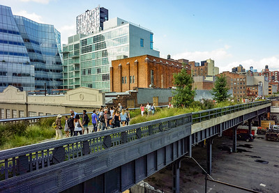
But this isn't "co-locating" a placemaking use with an existing utility use. What I am more interested in is using utility spaces that can support "mixed use" and are otherwise eyesores.
-- "The inside track on the High Line," NPR
-- "The High Line has been sidelined. When it reopens, New Yorkers may get the park they always wanted," Washington Post
-- "New York's High Line: Why the floating promenade is so popular"
-- "Why New York’s High Line is the perfect source of gardening inspiration"
Note that the first example of this kind of adaptation is in Paris, the Promenade Plantée/Coulée Verte ("Paris' Elevated Park Predates NYC's High Line by Nearly 20 Years (and It's Prettier, Too), TreeHugger) although it gets little notice.in the US.
Bentway in Toronto. The Bentway uses space under a freeway for park uses.
-- Bentway Conservancy
It's not the first example of reusing space under freeway ramps and pylons, but as a premier example of doing this well, it's an example for others ("Under freeway ice skating track opens in Toronto").
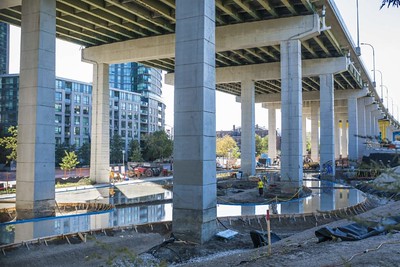
Bentway ice skating track under construction, Toronto. Photo: Eduardo Lima, Metro News
Under freeway spaces. Many places do put parking under freeway ramps. It's an acceptable use too. Or at the very least, treating the pylons as opportunities for murals.
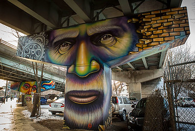
Corktown freeway underpass pylon murals, Toronto. David Cooper / Toronto Star. This pillar, called The Worker, recalls the neighbourhood’s working-class roots

Although at least one group has called for undergrounding of the transmission lines altogether ("Hydro-Québec begins groundwork for controversial substation pylons in D.D.O.," Montreal Gazette).
Another project is to reposition electricity transmission corridors as "Biodiversity Corridors."
The Biodiversity Master Plan was created by the winners of an international design competition, the team was composed of four firms: civiliti; LAND Italia; Table Architecture; and Biodiversité Conseil.

They proposed a re-do of three electricity transmission corridors, re-introducing plantings, adding trails and other amenities, and support to fauna, along three major city arterials in St. Laurent borough, which as a more suburban part of the city, is car-dominated,
Water infrastructure in Medellin. I write about Medellin from time to time because of how it has used investments in social and transportation infrastructure -- transit including bicycle sharing, gondolas, and escalators -- and libraries, parks and other facilities in association with infrastructure projects.
The program is funded in large part by revenues from the municipally owned utility, which runs both electricity and water systems.
Their approach is now called "social urbanism" by planning theorists, and it has contributed to a 90% drop in the murder rate in that city. (The rate is still high, over 600 deaths each year, but that's 5,400 fewer than the peak rate!)
-- "Medellin: from narco terrorism to a hub of innovation & social urbanism," RSA
-- "'Social urbanism' experiment breathes new life into Colombia's Medellin," Toronto Globe & Mail
-- "Medellín's 'social urbanism' a model for city transformation," Mail & Guardian
-- "Medellín slum gets giant outdoor escalator," Telegraph

In association with the construction of a gondola-based transit system in Medellin, the Northeastern Urban Integration project, converted typical arterial into a multi-modal, pedestrian focused street.
One project I wasn't familiar with adapted water reservoir infrastructure to add public spaces and facilities to neighborhoods that had little such space before ("The Story of How Medellin Turned Its Water Reservoirs into Public Parks," ArchDaily). From the article:
While developing a master plan for Medellin's urban lighting system, EPM, Medellin's public utility company, analyzed the Colombian city's infrastructure and nocturnal lighting system by superimposing a map of the system over a map of the city. What they found was an urban landscape blotted by "islands" of darkness.Water reservoirs in the US. Sometimes in the US, water reservoir areas are treated as parks, but over the past decade this has been seen as controversial because of the potential for water contamination as a spillover from the use, or fears of terrorism. Although now, the EPA is requiring that treated water no longer be stored in open reservoirs.
Much to the surprise of the utilities company, the dark spots were actually 144 water tanks that were initially built on the city's outskirts; however, thanks to the progressive expansion of Medellin's city limits, the tanks now found themselves completely surrounded by the informal settlements of the Aburra Valley. Even worse, they had become focal points for violence and insecurity in neighborhoods devoid of public spaces and basic infrastructure.
UVA La Alegría.
Through their Sustainable Urban Interventions Department (DIUS), EPM analyzed the 144 water tanks "based on aspects like usable land, population density, the neighboring community's needs, geological restrictions, the expansion of the aqueduct, and the surrounding area." They later chose 32 tanks and, from there, narrowed their list down to the 14 tanks most in need of intervention, giving birth the to ambitious project of creating quality public spaces in Medellin's poorest neighborhoods, dubbed the UVA or Articulated Life Units.


Ironically, what that will mean in some reservoirs is the ability for more park and recreation uses ("Remaking Baltimore's Druid Lake: $140 million water project has some residents hopeful, others concerned," Baltimore Sun).
Although this comes at the expense of water views and water-based recreation opportunities.
Labels: infrastructure, Transformational Projects Action Planning, urban design/placemaking, utility infrastructure, water supply and use
posted by Richard Layman @ 9:54 AM&Permanent Link
![]()
![]()


6 Comments:
Which utility line did Baltimore county turn down use of to connect to towson? The one around Falls road which has a trail that connects to lake roland? Why it is that most utility lines that have maintenance roads aren't used as pedestrian/bike paths is beyond me. Case in point, the Power lines from Herring Run to lillian holt drive on the east side would make for a likely well used bike route, especially when combined with improvements to Sinclair lane. (and Looks like would have been the route of north east side subway plan, from 1968.)
Baltimore County didn't do this. I recommended it, but my recommendation was disregarded and never made it into any public drafts.
But yes, the line you're thinking of along Falls Road is exactly the one I'm talking about. Plus, another one, also serving as a stormwater piping corridor along the Pataspco River.
And your point about the maintenance roads is spot on. We didn't walk the Towson corridor, but we did along the Patapsco, and I had that exact thought at the time, that the maintenance road basically provided everything you needed for a trail.
2. WRT "the east" I wasn't tasked to work on Eastern County issues, so I don't know what's up over there. (The grant was specific to the west and the Office of Planning didn't want me to address anything east. As it was technically, Towson is in the eastern county part of the plan, but I did do some Towson stuff since it was so integrated with "the west". I seem to recall that somewhere along the Beltway was where the county designated the line between its east and west urban sections.
The farthest "east" I got in a substantive way the Cromwell Valley County Park. (A big failure there.) There is a Ma and Pa train corridor across the street, used as an electric transmission corridor, but its topography is 100x worse than the one in Towson. So bad, I wouldn't recommend it.
But the CVCP recreation committee was so vociferously against a trail in their stream valley (which they restored, removing invasive plants, etc.) partly though because of problems from mountain biking in the adjacent city reservoir "park". In one of the rare compromises I made, I suggested taking out this recommendation because I feared that their vociferous opposition could scuttle the entire plan, not just the part about their park.
I did make another recommendation that stayed in, that I was proud of. To create a joint management plan for the county, city (reservoir), and state park (NCR trail) that were all adjacent.
I thought this could set the stage for a reconsideration of a trail there, since it was really the only option.
FWIW, Harford County has used old Ma and Pa corridors for trails.
(FWIW/2, my plan except for a couple instances, didn't address anything in the northern rural section either. I wrote a proposal for a grant to do a study there, which the Metropolitan Council agreed to fund, but the county wasn't willing to do any match, and they didn't keep me around to do it. With the 2010 election, the planning director--who wanted to bring me back--wasn't retained.)
The issue with using Ma and Pa sections is that it would require multiple bridge replacements, not to mention a route under the beltway. That said, west of the beltway, it is a trail to joppa road.
I think the stormwater pipe has gotten used in Avalon patapsco park, after the Dam was removed.
I didn't know about the Ma and Pa issue.
In the draft I did, semi related, I did recommend a trail in the "road separation" section of the I-795. Arlington has trail in that section in I-66.
Now I am in Salt Lake for family health reasons, and there is a short tunnel under 1300 East, continuing the Parley's Trail to Sugar House. The trail goes up into the Wasatch Mountains and part of it uses road separation ROW along I-80 (there are crossing bridges too).
https://www.flickr.com/photos/rllayman/50065501212/in/dateposted/
SHA wasn't absolutely opposed to tunnels and there were examples. But they didn't push it.
In the original draft, I did contrast best practices in the DC area (Forest Glen, 14th Street Bridge, Wilson Bridge) with freeway crossings in the Baltimore area. Of course, this was excised from the posted draft.
I didn't discuss in great depth Seattle, where the electric and water utility is a city agency. It too is used in not dissimilar ways to create projects that are more than rote examples.
One way was to support mixed civic use libraries, by including walk up windows for people to pay their utility bills. And they've done model stormwater capture green infrastructure projects.
One project I didn't know about when I wrote the piece was how to justify a street closure for a new electricity substation, they included a community center, interpretative exhibits, green space on the site, and a dog park.
https://www.seattletimes.com/seattle-news/politics/seattle-just-built-amazon-a-350-million-electrical-substation-and-network-with-a-dog-park/
NYC has a water treatment plant with a park on top. That project is almost 30 years old. Riverbank State Park is the park portion of the project.
https://www.nytimes.com/1992/09/01/nyregion/28-acres-roof-place-play-west-harlem-riverbank-state-park-under-construction.html
And some parking structures have park space on top.
Toronto's Scarborough has a project, The Meadoway, which utilizes an electricity transmission tower corridor. They will be planting it in natives and including a biking and walking trail.
https://themeadoway.ca/app/uploads/2019/05/The-Meadoway-Existing-Conditions-Report-FINAL_digital_21May19-resize.pdf
https://themeadoway.ca/
One of the partners is the electricity company.
The trail will be about 10 miles long and the corridor will connect Downtown Toronto to the Rouge National Urban Park.
https://www.pc.gc.ca/en/pn-np/on/rouge
As repurposing a utility corridor, it could be a model for use in dealing with other communities and utility companies in rethinking these corridors.
Part of what I was thinking in 2010 was at the time there were reports of vandalism and potential terrorist attacks against electric utility infrastructure. With trails, you add "eyes on the street" to corridors that normally have limited visitation.
Post a Comment
<< Home