Transit, stations, and placemaking: stations as entrypoints into neighborhoods
----------------
Note that the introduction and the conclusion have been significantly expanded since this entry was first published. Hence the change in the publishing date.
----------------
I have been meaning to write about this issue again since I got back from Seattle, but GGW beat me to the punch, with their entry, "Metro stations should be more individual."
 Although my take is broader and more comprehensive, I agree that Metro stations need to be more grounded in place and that the subway system and its stations need more "localization."
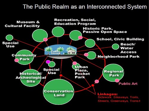
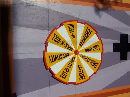
Right: graphic showing the concept of the integrated public realm framework. David Barth and Carlos Perez, AECOM.
The ideas derive from the concept of an "integrated public realm" (a concept developed by parks planner David Barth) and are captured in this entry, "Arlington County's bus shelters and a public realm framework of quality" plus more generally in the entry "Transit and placemaking," a piece from 2011 which jumps off from issues around the NoMA Station ("NoMA revisited: business planning to develop community") and the suggestion--too late it can't happen because of defects in DC's design and planning regime--of repositioning the ground floor of the NoMA station and the adjacent walkway to an arcade-like environment.
Transit systems are civic architecture, not just conveyances
We should recognize that a transit agency's primary function is to move people--it's a conveyance--while acknowledging the civic role in this function and leveraging stations and stops not just as connection points where riders enter and exit transit vehicles, but that in turn, stations and stops are civic places too, even if that element of transit infrastructure often has been ignored.
In the early part of the last century it was typical for there to be postcards of railroad stations, and these cards communicated the importance and prominence of stations as entrypoints into the city as well as the station's role of bringing people together.

Even if local transit systems for the most part aren't fronted by such grand buildings as Union Station in DC, or Grand Central Station in New York City, the 30th Street Station in Philadelphia, etc., today's transit authorities accomplish important functions and are vital to a community and key to local economic development.
-- Hagley Museum Railroad Station Digital Archives
-- Railroad Station Home Page, postcards
The DC subway system was designed to take suburban residents to their jobs in the city
The transit infrastructure was never intended to build and strengthen neighborhoods, nor to enhance the specific places where stations were constructed. It was designed to get suburban commuters into the city to work, and back home in the evening.
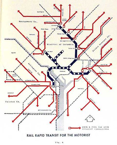
1965 planning map for the Washington subway system. Note the legend: "Rapid Rail Transit for the Motorist."
Transit stations are the "crossroads" of a neighborhood
What is complicated for a transit agency is that the "meaning" the stations possess isn't solely focused on the transit function and connection.
Stations and stops have meaning within a city or county at multiple scales depending on the nature of the connection: block; neighborhood; neighborhood commercial district; major activity or employment center; district/sector; city; county; metropolitan area; and region.
For the most part, people are concerned with a station or stop in the context of their neighborhood/district. Stations--railroad, subway, light rail, and maybe streetcars (and some cities have higher level bus-oriented stations too, DC specifically does not)--are the places where neighborhood and the transit system intersect and come together. So the station takes on a "crossroads" function, and becomes a neighborhood level public square.
Transit stations in neighborhoods end up being the single most visited public place in that community--more than a post office, library, or school.
But right now, you can't even put in a bulletin board about community events in a Metro Station. On the other hand, station grounds aren't parks either, and a community (this is an issue in Takoma now) shouldn't expect that WMATA manage stations as public parks.
The transit agency has no control over the "meaning" of a station as a key element of a neighborhood's public realm, but they do have a responsibility to acknowledge this role, and should work to satisfy some of those expressed needs that communities have with regard to the station's role as a key civic place and community crossroads.
 Transit infrastructure as branding and other functions
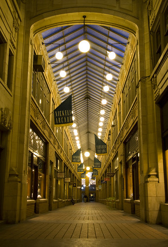
Wouldn't it be cool if the walkway next to NoMA station had been conceptualized as an arcade? Left: Nickels Arcade, Ann Arbor. Flickr photo by FarzinPhoto.
My writing on this topic has focused on transit infrastructure, marketing, and wayfinding in terms of bus stops (my blog entry "Making bus service sexy and more equitable," and these influences, the out-of-print report from Cleveland, Transit Waiting Environments, plus the EMBARQ report, From Here to There: A creative guide to making public transport the way to go) which state that stations and stops are key for two reasons:

Right: graphic from the Wall Street Journal on the amenities associated with the implementation of high quality bus rapid transit services.
1. Transit infrastructure brands transit: through design, condition, quality, and maintenance, they communicate whether or not a communicate values transit and sustainable mobility, or merely considers transit service to be a social service for the poor. Modern BRT systems, such as in Cleveland or the York Region of Toronto execute this idea the best. See "Better bus (rapid transit) service revisited".
2. Transit stops and stations are key marketing touchpoints: bus stops and shelters not only communicate that transit exists and is available, they provide information that people can use, whether or not they are at the stop. In general, the opportunity to leverage Metro subway stations to market transit and/or sustainable mobility is mostly wasted.
But this argument continues to expand into a more complete framework:
 3. Transit stops and stations should better integrate within neighborhoods: since 2006, with the commencement of planning for the implementation of the DC bus shelter contract with Clear Channel, I have made the point that transit shelters can also be utilized and better connected to neighborhoods, through the incorporation of historical information, and/or artistic elements, and/or neighborhood information, and/or retail district information.
Note that most neighborhoods don't have the resources to put information into the bus shelters. The business improvement districts tend to do this, but I think Adams Morgan BID does the best job locally, although I have to say that the Mount Pleasant merchants group has just introduced similar signage that is even better.

In Baltimore, the MTA does a decent job of providing information within bus shelters. And the Walnut Street bus shelters in Philadelphia are specifically arty (pictured above).
4. Transit stops and stations should, when practical, interpret and present transportation-transit history: the Center City District in Philadelphia does this, and here and there transit systems elsewhere do it to. Baltimore MTA has interpretational signage in old trolley waiting stations on Charles Street and in Catonsville, and along the light rail.
The transit authority in Lancaster, PA has great interpretive information presented at their main bus station in Downtown. Back in 2005, Tri-Met in Portland had history panels posted in buses, comparable to ad panels. The Silver Line "BRT" in Boston has an extensive system of interpretation kiosks.

Right: transit history interpretation sign in Lancaster, PA.
Note that the DC Heritage Trails cultural interpretation signage program includes transit history as part of their presentations on neighborhood history.
And I think that DC could do a great job of providing historical interpretation panels in the existing trolley waiting-turnaround stations on Connecticut Avenue NW and 14th Street NW.
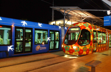
5. Transit vehicles can be an element of city/urban design and branding (extending the first point that transit infrastructure brands transit): Montpellier, France, which positions itself as a city committed to being design forward, had Christian Lacroix design the livery of its light rail vehicles ("Design as a city branding strategy").
Right: Image from the website of the local government, the Agglomeration of Montpellier, France.
6. Transit vehicles can be an element of transit marketing: the Pittsburgh bus system probably does the best job of putting messages on buses that promote transit. But other systems do this as well. MTA in Baltimore has a great bus with a more "urban-market" message of "Rollin' with MTA."
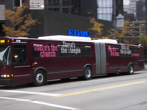
Left: Port Authority Bus, Pittsburgh, with this ad message: "There's the church, with the steeple. Here's the bus, with all the people," making the point that buses carry a lot of people.
WMATA and revisiting transit and placemaking
And with the hullaballoo about WMATA's imperious destruction of independent plantings at the Dupont Circle station ("Metro threatens Phantom Planter with arrest if he tends his Dupont Circle station flowers," "Metro rips out Phantom Planter's flowers at Dupont Circle station" Post), complaints about WMATA's implementing of some interior changes at the Bethesda Station, to make the station more usable, especially in terms of lighting ("Metro Chooses Bethesda Station To Test Future Design Concepts," WUSA-TV), and the negative response by some historic preservation interests ("Past is present: Metro's historic ride" op-ed by the director of the DC Preservation League in the Washington Business Journal), plus my observation of some Sound Transit practices and their contrasting approach of making light rail stations entrypoints to neighborhoods, I thought it would be worth revisiting the topic.
-----
Note I do understand some serious WMATA concerns with regard to safety liability with regard to the plantings at Dupont Circle.

The key issue is that architecturally, the WMATA system evinces all the problems I excoriate in writing about starchitecture.
For the most part, such buildings are more like art and sculpture and the site and building design purposely disconnects and holds at arms length the community and the built environment that lies beyond the lot lines.
-- Docomo webpage on the architectural design of the WMATA system
-- the section of this WMATA case study on architecture covers the issues too, from Metro Cincinnati
Yes, Harry Weese designed the station interiors to be very specific and with a design consistent across the system, with vaulted tunnels, etc. ("Harry Weese, 83, Designer Of Metro System in Washington," obituary, Washington Post). But the stations were never designed to connect to and enhance neighborhoods or the community outside of the station. Inside, despite the vaulting they are dark, the concrete looks dingy, etc.
Still, this self-referential internally-focused architectural attitude shapes WMATA's placemaking culture to this day. In short, there isn't much of a placemaking culture, a recognition that transit stops and stations have a role to play in quality of life.
(Note however with regard to bus stops, except for bus stops on WMATA station sites, bus stop sites are controlled by the local jurisdictions, not WMATA.)
 The light rail bridge in Tempe, Arizona has an architectural lighting treatment. Flickr photo by Bogmol-Ron.
For example the canopy program for WMATA subway stations could have incorporated site- and neighborhood-specific artistic elements but doesn't. (I am in the process of writing a proposal to incorporate architectural lighting elements into these canopies.)
But there are other missing elements.
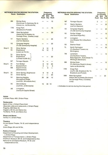 Right: this page from the 1978 WMATA Ride Guide for L'Enfant Plaza Metro Station lists area businesses.
For example, there aren't community information boards at Metro Stations. Maps at Metro stations don't denote community commercial districts--it's seen as promoting for profit businesses, even though they do show strip shopping centers (but not individual businesses) on station maps in the suburbs. (WMATA doesn't list supermarkets on bus and rail maps either. Pittsburgh does.)
For the most part, Metro doesn't allow vendors to set up on station grounds (partly this is because the spaces are constrained and they are concerned about unsafe conditions) which can be a placemaking element. Retail, when potentially viable, hasn't been integrated into stations. WMATA bus shelters on station grounds don't incorporate advertising, which reduces revenue available for upgrading the bus shelter experience.
Another element is that WMATA could better monetize air rights above station entrances in dense areas, which would provide better conditions upon exiting the station, and potentially could support community uses. But that is a topic for another entry.
I was shocked that people were shocked that WMATA wasn't supportive of guerrilla gardening at Dupont Circle. WMATA is very much a bureaucratic government organization shaped in very specific ways. Plus union contracts make it almost impossible for "volunteers" to provide "services" to the system that would otherwise be accomplished by paid workers. Bottom-up initiatives of any sort are pretty much discouraged.
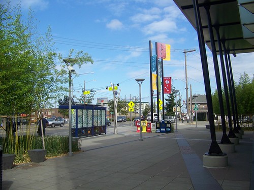
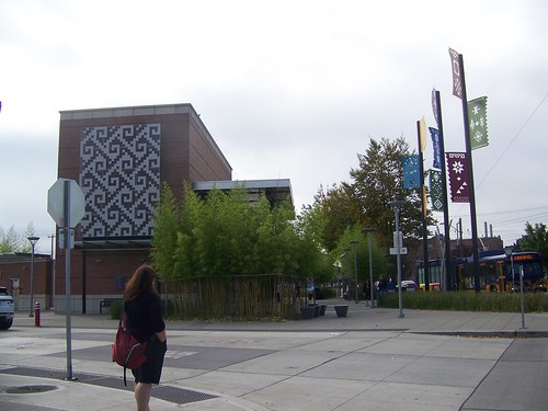
Sound Transit. While I didn't take many photos of their light rail stations, there is no question that the Seattle system's light rail stations are more purposefully designed to integrate the transit system and its infrastructure to the neighborhoods in which stations are located. They are not quite but almost welcome centers to the neighborhoods.
(By contrast STM in Montreal does allow market stores and garden stores to be placed on the grounds of Metro stations. And in Mont Royal, there is a visitor center on the grounds of the station, but it is not part of the station entrance, it is a separate structure.)
Like the suggestion in the GGW entry, the Sound Transit stations incorporate site-specific art, although it is not as gutsy as the public art program run by Tri-Met in Portland (see "When people don't have experiences, site visits are the way to go") as executed on the Interstate/Yellow Line.
And while not perfect, there is clearly a desire to connect and integrate each station within the neighborhood and its built environment, in support of neighborhood revitalization efforts (the latter has happened for the most part independently of concerted WMATA efforts within DC, with the exception of Petworth, where WMATA sold part of the station property for an apartment complex, and this project has accelerated revitalization on Georgia Avenue in significant ways).
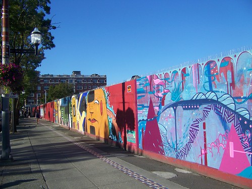
Where this was most evident was at a light rail station under construction on Capitol Hill in Seattle. From the bus, I had seen "a mural" painted on the fences of a construction site, but didn't think very much about it.
Later, I walked through the area and was able to examine the site in much greater detail.
I was truly surprised to discover that the various art and cultural history interpretation projects displayed on the walls were part of the light rail construction site. It was authorized and encouraged by Sound Transit! I don't think this would ever happen with WMATA.
Conclusion
Not reaping the value of transit infrastructure in placemaking and revitalization significantly reduces the ROI (return on investment) and multiplicative development power that a transit network can provide--as proven by the success of transit-oriented and transit-adjacent development in DC and Arlington County--which in many respects has been happenstance in DC and more purposefully achieved in Arlington.
I do believe that if we begin to define overtly the civic role of transit infrastructure in terms of architecture, connection, and the public realm, than it becomes easier for a transit authority to acknowledge its importance and incorporate achievement of civic functions within the organization's planning goals and objectives.
At the same time we have to recognize that the foremost function of a transit agency is its role as a mover of people to and from various places around the metropolitan area.
To finance the incorporation of civic functions within transit infrastructure, especially stations, perhaps non-transit fund sources are required.
At the same time, localities have to acknowledge that transit infrastructure has broader roles, as branding, as community crossroads, and they shouldn't try to value engineer and cheapen every possible element of it, in particular how it looks.
A good example is the Silver Spring Transit Center. Irrespective of all the construction defects and the contentious process involved in trying to fix them ("Foulger-Pratt: county fixes for Silver Spring transit center ill advised," Gazette), the station was never designed to be very attractive. It's just a big ugly parking garage for buses.

Also, the Red Rose Transit Authority in Lancaster County, Pennsylvania created the Queen Street Station, which is also much more attractive than a typical bus station.
On the other hand, the Lancaster station accommodates significantly less bus traffic than is required in Silver Spring, so it is much easier for them to lessen negative impacts (buses are big and noisy) and take on a smaller footprint.
Still, it is unfortunate that Montgomery County didn't take more care to make the Transit Center more attractive, commensurate with its role as key civic architectural element of one of the county's major conurbations.
With regard to WMATA, in order for things to change, we have to better articulate what the issues are. This entry is a step forward toward such a discussion.
Sound Transit Photos
King County Metro doesn't have advertising in bus shelters. But they do allow the shelters to incorporate locally produced art. Often the drawings are related to the neighborhood in which the shelter is located. In addition the glass panels of the shelters have an artistic treatment.
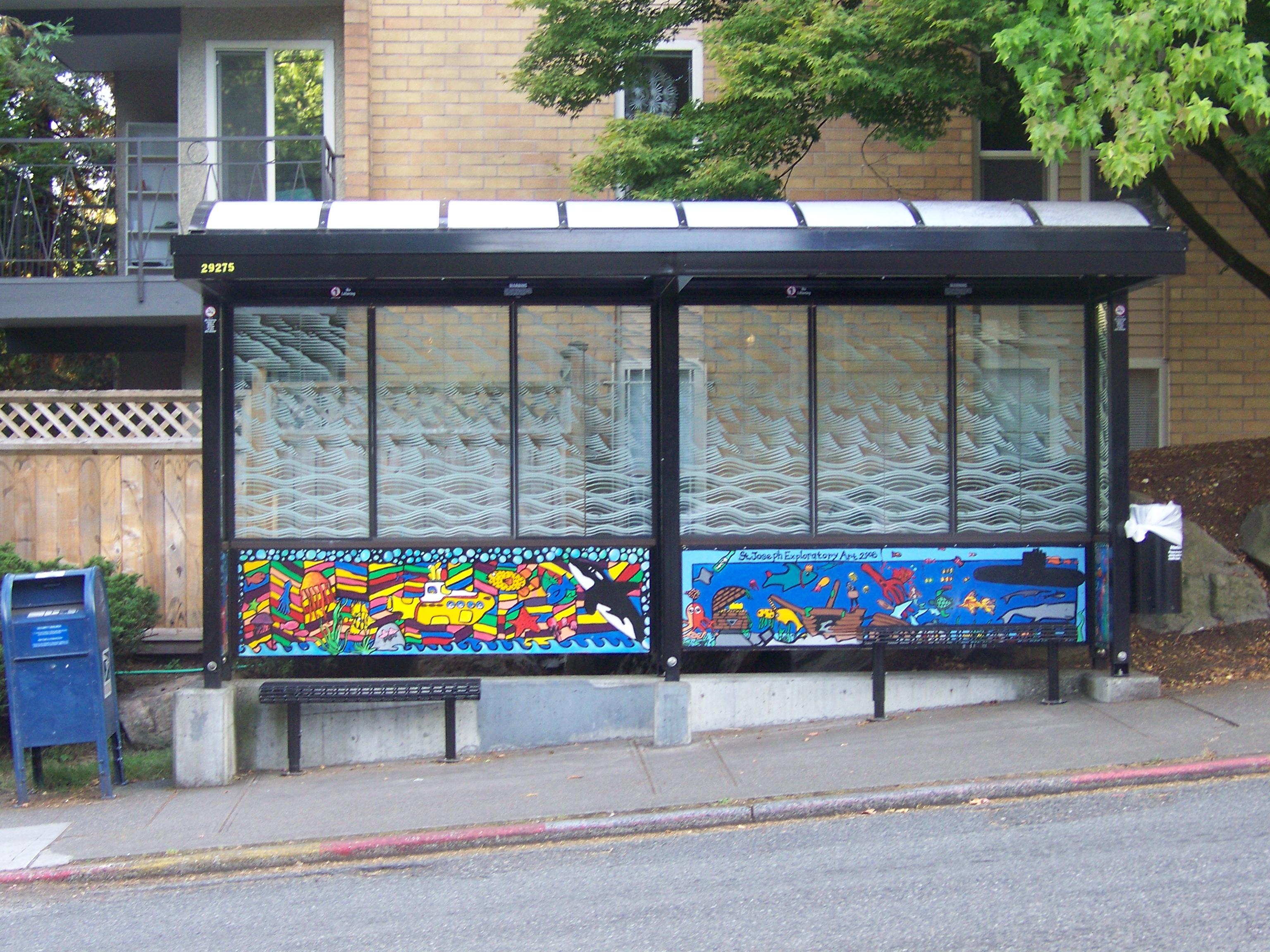
Exterior, Beacon Hill Light Rail Station, Seattle. The bus shelter incorporates public art. Artistic panel stamping is visible in the sidewalk. Guidons reflect a textile theme, which is incorporated in an art work on the station walls, and were based on textiles provided by area residents during the station design process.
The Beacon Hill Station also has site-specific plantings. (cf. the Dupont Circle Station debacle.) Granted they are maintained by the transit authority.
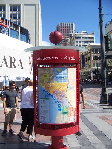
While this tourist wayfinding kiosk in Seattle was not produced by Sound Transit, this kiosk has also been installed at some light rail stations, providing information to tourists. (MTA's light rail stations in Baltimore no longer have accurate area maps posted at the stations.)
Mural on construction walls at the Capitol Hill light rail station site. It's not even the most arresting of the murals painted there, but I can't seem to find/maybe I deleted the photo of the most astonishing of the murals.
A mural element listing qualities that Seattleites identify with.
Panels on the neighborhood's history and Seattle's development over time, at the Capitol Hill light rail construction site.
One construction mitigation tactic is the support of a local information website, and advertising its existence in a panel on the construction site wall.
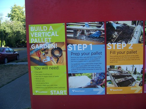
Ironically, given the recent WMATA experience with plantings, one of the exhibits on the construction walls explains how to use wooden pallets to do vertical gardening.
Note that Sound Transit's logo is imprinted on the information panels.
Labels: action planning, public realm framework, public relations and communications, transit infrastructure, transit marketing, transportation planning, urban design/placemaking
posted by Richard Layman @ 8:18 AM&Permanent Link
![]()
![]()


24 Comments:
The Clear Channel contract might preclude a lot of stuff on bus stops.
Also see Alex's recent entry on the new stainless Rosslyn metro renovations.
i hear you on placemaking, but honestly did not react in a positive fashion to most of your pictures. the bridge in lights, however, would be a great move.
Just having the ability now to do special print smartrip cars will help. (cheery blossom, inauguration, 4th of july, etc). I know that isn't local, precisely, but this is the "nations" metro in a way that no other will be
And yes, this is a bigger task -- how to turn a auto substitute commuter rail into a place-making urban subway.
WMATA was WRONG in attacking Docter for what he did. They should have paid him for it. The concerns with liability have sapped a lot of energy and creativity from our society . I hate this mentality and it needs to be corrected.
dc would consider what it is doing with bus shelters to be in line with these ideas, which started expanding when I attended some of those early planning meetings. My point on bus stops as marketing touchpoints was revelatory to the DDOT people running the meeting.
But yes, the contract is limiting too.
2. wrt "the photos" my point isn't necessarily that the artwork at the Beacon Hill is stunning or that the murals and projects on the construction wall at the Capitol Hill station are the best in the U.S.
They convey an attitude that Sound Transit isn't solely concerned about connecting people by transit, but also the agency is concerned with connecting places generally throughout the metropolitan area and specifically at those loci where neighborhoods and the light rail system come together.
That's a key difference between say WMATA and Sound Transit. But it's also a difference that derives from the times. WMATA was designed in the 1960s and 1970s and the understandings on this element of transit infrastructure as civic architecture at least in its external dimensions, wasn't considered much at all.
In any case, the expanded introduction ought to make a better argument that the earlier iteration.
Right, sorry. I was looking at some italian public art and realizing how much better they do it over there so just being a snob.
Few other points:
1. I see a lot of people using the maps on bikeshare station, but not many on the bus stops. I suspect it is the scale and also the openness.
2. when I get stopped on the street, it is usually for someone to ask me which way is K st, which way is the metro station, etc. Big signs can help.
3. I'd also tie this in into public charging stations and advertising. Yes it will be abused in DC by school kids/homeless. But worth a try.
4. In another context, see airlines doing a "heritage plane" and also you've talked about streetcars. Explain to people something about the history of your system. Those stupid local history board -- which I think are just obstacles -- tourists love them. Bizarre but true.
5. Yes, station entrances could be better designed. Certain value in consistency and making them easy to find. Keeping them clean is probably just enough. Bigger issue is when you close one set of them and hard for people to find the other set. Goes back to having mapping around the stations.
again, thanks for this. (I didn't think you were a snob. You're right about the difference between European cities and the US in terms of adornment and civic architecture.)
I'm probably not gonna get any benefit from it, but I laid out a bunch of these kinds of placemaking points wrt the Eastern Market Metro Station, as part of a proposal for work wrt the creation of an "information hub" there. But because separately the Barracks Row Main St. is doing their own plan, I don't think "my" points will come to any fruition.
But you're absolutely on point about the need to integrate these points with wayfinding. I have written about bike share maps being used by nonbicyclists, and I think your point about size of map is interesting.
- this blog entry from 2009 covers the proof of concept signs Christopher Edwards and I did wrt Florida Market, but I also cover broader issues on wayfinding
http://urbanplacesandspaces.blogspot.com/2009/05/florida-market-proof-of-concept.html
I'd been meaning to write too about opposition in NYC neighborhoods to the installation of wayfinding signs, which I see as an abrogation of a neighborhood's responsibility to be welcoming to others. I can't seem to find the link.
But this is about the new program:
http://www.wnyc.org/blogs/transportation-nation/2013/jun/24/wayfinding/
NYC, like London's Legible London program, is using the same mapping graphic system for the signage on the bike sharing stations.
Your point about elec. charging and such I realize is an element of the mobility shed arguments I make about transit infrastructure. (And tried to push in our bike sharing consulting business, but the velocity around installation supercedes consideration of broader concerns--at least based on experience in Chicago, where we proposed to integrate other elements like wayfinding and elec. car charging into the program.)
http://urbanplacesandspaces.blogspot.com/2008/09/updating-mobilityshed-mobility-shed.html
The mobility shed piece is probably due for an update.
And then combining this piece + writings on wayfinding + on the mobility shed/transit shed arguments into a single position paper independent of the blog would be worthwhile.
this is the article I was looking for that discussed resident opposition to wayfinding signage in Manhattan.
http://thevillager.com/2013/05/09/way-finding-signs-driving-downtowners-up-the-wall/
I just figured out where I had to go to find the link (my email box, it was from the TCN newsletter).
100% agree with the sentiments expressed there, but there are other ways wayfinding create value.
Perhaps again in 5 years pointless and everyone will have a GPS/map on their phone.
However, for instance, a big sign on the bikeshare station on 21/M pointing "5 blocks to Gerogetown!" would help a lot would save me 5-10 conversations a year.
...but what about the value of these conversations in terms of "social bridges"?
Anyway, I get insight into wayfinding needs on the basis of these kinds of questions, as well as how individual perspective shapes the answers that residents give, sometimes in ways that seriously result in bad directions.
And speaking of another good book, at least at the time, _Maximarketing_, which was about maximizing marketing channels, mobile data-maps is just one channel.
You still need other ways to provide the info, and people consume it differently in different forms, etc.
The new building under construction at 2nd and N NE, next to the NoMa station, will have retail bays facing the station, creating a bit of an arcade feel. It's not going to be Nickels, but it's better than nothing. :P
that's good to know. I am not sure that was part of the original design for that building, was it?
NYC Subway wifi subwayreads.org campaign provides special access to articles, books, poems
https://www.amny.com/transit/l-train-shutdown-citi-bike-1.20589744
8/23/2018
Interesting story, good images, about the urban design improvements at a Philadelphia trolley portal in West Philadelphia:
https://www.philly.com/philly/columnists/inga_saffron/septa-trolleys-west-philadelphia-spruce-hill-baltimore-avenue-20180927.html
I've made the point many times, starting with bus shelters, that shelters and stations are marketing touchpoints for the transit system. And whether or not they are maintained to high quality is an indicator of how valued transit is.
https://www.seattletimes.com/seattle-news/transportation/seattles-bleak-downtown-sound-transit-stations-have-nowhere-to-go-but-up/
3/19/2023
"Seattle’s bleak downtown light-rail stations have nowhere to go but up"
CTA unveils plans for space beneath new Red and Purple Line el tracks
https://archive.ph/guWOP
Crain's Chicago Business
The Chicago Transit Authority is proposing several new public amenities in its final plan for the space under the new el tracks between the Lawrence and Bryn Mawr stations. The project is part of the first phase of the $2.1 billion modernization of the Red and Purple lines.
The concept for the space includes a pedestrian trail, dog parks, playground, fitness area, benches and a plaza space for community events.
https://www.bloomberg.com/news/features/2024-08-02/building-more-beautiful-bus-stops-and-stations-can-pay-off
What a Beautiful Bus Stop Can Do
Stations and shelters for bus riders don’t get much design attention from architects. A new study argues that quality aesthetics and amenities pay off for transit operators.
Apart from increasing passenger satisfaction and ticket revenue, building more attractive bus facilities would draw more riders to public transportation, reducing emissions and congestion associated with private car use. The practical implication from the study is that beauty should be an explicit design consideration for transport services, Cartenì said, as the costs are offset by the benefits. Any improvement in aesthetics, comfort, personal safety or services contributes positively to travelers’ willingness to pay.
This is backed up by earlier research. About a decade ago, Cartenì noticed a difference between the two subway lines in his hometown of Naples: The “art metro” line — which features stations heavily decorated with contemporary art — seemed to attract more riders from further afield than the other, more utilitarian metro line. In a study, he found that people would be willing to pay roughly 40% more to use the more visually appealing transit system.
Other transportation researchers have also delved into the role that waiting facilities and amenities play in the ridership experience. One 2016 study of transit stops and stations found that passengers waiting at stops equipped with shelters and real-time arrival information perceived time passing more quickly than those in unsheltered stops.
======
https://web.archive.org/web/20240910050857/https://conservancy.umn.edu/server/api/core/bitstreams/bcaa1af3-0d59-416a-ada8-def4acef1c9d/content
Perception of Waiting Time at
Transit Stops and Stations
https://palmbeachartspaper.com/its-a-wrap-delray-artist-creates-colorful-mural-for-brightline-train/
It’s a wrap – Delray artist creates colorful mural for Brightline train
The wrap is part of a marketing initiative called “Love the Palm Beaches,” a collaboration between the Cultural Council for Palm Beach County and Discover The Palm Beaches, and is aimed at boosting tourism.
“The Palm Beaches is known as Florida’s cultural capital,” says Dave Lawrence, CEO of the Cultural Council. “We have an incredible lineup of arts experiences and are home to many talented professional artists like Meghan. We’re thrilled to feature her work, which reflects our destination so beautifully.”
https://news.artnet.com/art-world/chloe-bass-creative-time-new-york-subway-2685595
Chloë Bass Is the First-Ever Artist to Take Over the New York Subway Sound System
f you hear something, free something is the New York native’s first sound art project, and it is the first-ever takeover by an artist of the sound system in Gotham’s labyrinthine subway complex. Waiting on selected mezzanines, riders hear a deep, attention-getting tone (designed in collaboration with artist Jeremy Toussaint-Baptiste), followed by one of 24 announcements—though the voices may challenge the definition of that last word, as what you’ll hear isn’t always strictly informational, but rather evocative.
Each announcement—they will play in English, Spanish, Arabic, Bangla, Haitian Kreyòl, and Mandarin—is followed by the title of the project, which recalls the ubiquitous exhortation “If you see something, say something,” urging riders to protect each other from danger—or, if you like, surveil one another. Ticker displays transmit a brief explanatory text penned by the artist. Posters in the stations will also clue straphangers in to the project, but it may just be that some will hear the announcements while not seeing the posters, and go on about their day with a bit of mystery.
Sound is one of the things that drive subway riders crazy, I pointed out in a phone interview with the artist. Announcements from conductors often come over the speakers in a garbled mess, and riders look around at one another, incredulous, hoping it’s not life-saving information being conveyed. Some stations are also so loud as to be potentially damaging to the human ear.
New York public art presenter Creative Time approached Bass with the same question it poses to the artists it solicits: What’s your dream public project? Having created a mosaic that combines found photographic imagery and her poetic texts at a Brooklyn subway stop in 2023, the artist was already thinking about the subways, and jumped at the chance to have the nonprofit support a project that would go wider. Over the years, Creative Time has presented numerous high-profile projects, including Tribute in Light (2002), which recreates the Twin Towers in light annually on the site where they stood, and Kara Walker’s massive sugar sphinx, A Subtlety… (2014). It also organizes a much-anticipated annual convening, the Creative Time Summit.
“If you hear something, free something engages the largest transit system in the Western Hemisphere, a place where an incredible complexity of public life unfolds,” said Creative Time curator Diya Vij in press materials. “The MTA serves millions of New York City residents daily, spanning every single neighborhood and social boundary. It is where every denomination of New York City meets. For this truly public art work, Bass offers a monumental but fleeting gesture that seeks to change the way we relate to each other in public life and public space. She asks us to consider, if we change what we hear, can we change how we feel, and in turn, will we be better neighbors?”
https://www.crainsnewyork.com/transportation/mta-struggles-fix-dead-mall-under-new-york-city
4/17/24
Descend into the 42nd Street station at the Port Authority Bus Terminal, walk the lengthy mezzanine under Eighth Avenue, and the first thing you’ll likely notice is the blight of more than a dozen shuttered shops.
Shelves that once held items for sale lay strewn behind glass storefronts. A former newsstand with a tiered candy kiosk is caked in grime. Stacked buckets of construction sealant peek from behind a haphazardly papered-over shop window.
The scene is very different compared to much of the twentieth century when newsstands, candy stores and shoe-shine shops peddled goods and services to commuters navigating packed subway mezzanines and platforms.
Today, a staggering 83% of the subway spaces that in 2019 could have hosted retail are vacant or have been repurposed by the Metropolitan Transportation Authority, quietly helping to fuel the perception that the system is desolate and dangerous. Only 57 of 195 available shop spaces host tenants; another 17 are under construction and 30 more are in contract negotiations, according to the MTA. The authority’s real estate team said it has taken dozens of the more tricky-to-fill spaces offline for storage and other internal uses. In March 2019, the MTA said it had 326 active retail spaces in the system, and roughly 130 of those, or 40%, were vacant at the time. Based on the 2019 figure, just 17% of subway shop spaces are currently occupied.
The MTA is trying furiously to fill the spaces — reducing rent in some cases, trying out new uses in others, even offering free rent for public art installations — to maintain a sense of vibrancy and soften the perception that riding the subway is risky. A spike in crime in recent months and a few high-profile incidents, including a Downtown Brooklyn shooting, haven’t helped. Street-level retail is in a much healthier position: Retail rents in Manhattan have risen for six consecutive quarters, and the number of available ground-floor spaces has dropped 33% from a mid-2021 peak, according to CBRE data.
“We’re entertaining different types of uses,” said David Florio, the MTA’s chief real estate transactions and operations officer. “That’s been the most important: to keep it live, keep an activation because people like to see something, basically, open and activated within the subway.”
Retail space in the subway generated $9.5 million for the authority in 2019; transit officials told Crain’s that they expect a little less than half that amount, or $4.3 million, this year. That’s a sliver of the MTA’s $19.3 billion annual budget. But as a highly visible part of the system, bringing an extra bit of life to stations and platforms is just as much about enhancing the customer experience as it is about squeezing every penny out of MTA assets.
“Transit retail has to be looked at as eyes-on-the-street, as an amenity,” said Susan Fine, who served as the MTA’s director of real estate in the 1990s, where she led the transformation of Grand Central Terminal into a popular retail destination.
Fine, now the principal of Fine Development Partners, went on to develop the MTA’s first privately financed subterranean retail center in 2016: a 325-foot-long corridor of diverse food offerings, trendy shops and kiosks called the Turnstyle Underground Market. Located at the 59th Street-Columbus Circle stop, the Turnstyle shops are outside the actual subway turnstiles, so customers don’t have to pay a subway fare before shopping. By contrast, most subway retail is beyond turnstiles in station mezzanines and on platforms.
Turnstyle, which features roughly 40 storefronts, was a smash success when it first opened. It has suffered the trials of Covid as well, and on a recent weekday, just over half of the storefronts and kiosks were open for business. But even at half occupied, it’s a success story for a system rife with vacancies.
“The urge to linger in the subway has gone,” said Fine. “When the spaces are dark it makes the station feel unsafe. There’s nothing worse than an empty space.”
It wasn’t until December 1948 that the subway boasted its first retail tenant in four built-out shops on Manhattan station mezzanines. The Loft Candy Company leased four underground storefronts for an annual minimum of $10,000 at each space; the deal also provided 10% gross sale payments to the city, according to a 1949 newspaper article in the New-York Tribune.
The MTA created a rent relief program in October 2020 following pleas from struggling retailers. Under the policy, qualifying tenants had their rents reduced to 10% of their base rent or 10% of a store’s gross sales — whichever was greater. About 105 tenants across the MTA’s network originally took the agency up on adjusted rents.
“Stations are community hubs,” said Smith, the retail transit consultant. “The more we can think about them as such — as opposed to just a utilitarian place to get people in and out of — whether it's commercial, cultural or otherwise, I think will only enhance the experience for riders.”
Recently, the MTA has begun covering up some empty storefront windows with advertising. The authority has also launched a rent-free pilot with Midtown East-based arts nonprofit Chashama, which connects visual artists with affordable workspaces, including at the Fifth Avenue-53rd Street station near Central Park.
https://www.crainsnewyork.com/transportation/mta-seeks-firm-turn-grand-central-madison-retail-destination
4/2/24
https://www.bart.gov/news/articles/2025/news20251107
Meet the artists who created original works for BART’s Downtown San Francisco escalator canopies
Recently constructed canopies along San Francisco’s Market Street are protecting station escalators and helping to beautify the busy downtown corridor with four site-specific artworks that reflect the neighborhoods around them.
The canopies are being constructed as part of the San Francisco Station Canopy Project, happening in tandem with BART’s San Francisco Station Escalator Replacement project, which is installing and replacing escalators at Embarcadero, Montgomery St., Powell St., and Civic Center stations.
The new canopies aren't just coverings for the escalators. Each structure is equipped with LED lighting, multiple security cameras, digital screens that display real-time transit information, and motorized gates that allow the entrances to be locked at street level when stations are closed. In addition to protecting the new escalators from wear and tear, the canopies provide an extra layer of station security and cleanliness, all while brightening Market Street with placemaking artwork that subtly reveals itself as you travel between station and street.
Incorporating art was an important piece of the canopy project, as was ensuring the imagery resonated with the people who live along the corridor.
“It was crucial to not view Market Street as a monolith during this process,” said BART Art Program Manager Jennifer Easton. “The street has different communities and parts to it, and that was a key aspect to convey with this project."
The process of translating the artworks onto the surface of the fiberglass-reinforced plastic canopies is a saga unto itself. BART worked with VIA – A Perkins Eastman Studio to develop a method that would maintain the integrity of the artists’ original designs while ensuring the works would last for decades in their outdoor environments.
“There was a lot of study and analysis to get this right. I don’t believe anyone has done something quite like this for a transit project,” said architect Steve Line of VIA.
VIA’s final designs utilized fiberglass-reinforced plastic that is extremely durable but also pliable enough to achieve the gentle curved shape of the canopy undersides.
https://www.theglobeandmail.com/canada/article-will-the-eglinton-crosstown-carry-toronto-forward
Will the Eglinton Crosstown carry Toronto forward?
This design language was created by Montreal architects Daoust Lestage Lizette Stecker and Toronto architects gh3*; Arcadis, DIALOG and NORR executed the station design.
“The theme of the line was simple, light-filled boxes,” said Beth Kapusta, a consultant and the former head of design excellence at Metrolinx, who was touring the system.
“It was meant to be a strong, coherent system of clarity and simplicity.”
Toronto transit users deserve this kind of care; the TTC’s recent building projects are scattershot messes. And while Crosstown’s expanses of white will require rigorous maintenance – let’s see how they look in a year – the atmosphere on the trains and in the stations was crisp, orderly and comfortably lit.
Crosstown is really two conjoined systems: a subway-like stretch that moves people long distances across the city, and a surface line that stops frequently and serves local trips.
That tension reflects its origins in Transit City, the mid-2000s plan championed by Toronto’s former progressive mayor David Miller, which aimed both to extend rapid transit to underserved zones and remake postwar arterial roads into something more urbane. Transit and land use are inseparable; here they would be linked by a coherent vision.
Eglinton would be an “Avenue,” with a capital A: a tree-lined boulevard framed by four- to six-storey buildings, informed by European precedents and advice from French urbanist Antoine Grumbach.
Yet Toronto’s postwar geography bears no resemblance to the dense banlieus, or suburbs, of Paris. Eglinton in its outer stretches is extremely wide, shaped by engineers as a high-speed arterial road. On Sunday morning near Victoria Park station, a woman trudged with shopping bags toward a nearby strip mall. There were no boulangeries in sight.
Nor are there likely to be. Recent research from the University of Toronto’s School of Cities found that building along the line, in the past decade, has been very tightly concentrated at the central corner of Yonge and Eglinton.
In a design sense, the line is a restrained triumph. Its stations and stops share a coherent language: large windows and skylights, white-painted steel, expanses of white tile, and tangerine accents. The above-ground station buildings feature crisply detailed canopies, integrated public art and clear wayfinding.
Mapping development changes along the Eglinton Crosstown corridor
https://schoolofcities.utoronto.ca/mapping-development-changes-along-the-eglinton-crosstown-corridor/
BART Station Experience Design Guidelines, 2018
https://www.bart.gov/sites/default/files/docs/20180212_BART_SEDG_Final-lowres.pdf
Post a Comment
<< Home