Putting streetcar planning and implementation in context

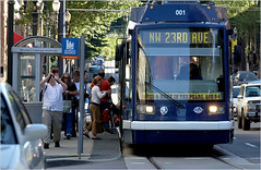
More than 10,000 residential units have been built and $3.5 billion has been invested in property within two blocks of the streetcar line, according to Portland Streetcar Inc., which operates the system. Photo: Dana E. Olsen/The Oregonian, via the New York Times.
No one with sense can go to Portland, ride and analyze the streetcars, and come back to DC and argue that streetcars, for whatever ridiculous reasons and convoluted logic they come up with, _can't_ work in DC. Our roads aren't too narrow either. (Portland Ground is a great website for photographs of Portland, including transit.)
1. I do think that implementing streetcar transit systems are probably the number one neighborhood-based economic development tool that cities can engage in. Primarily because what cities must do--generally--is stoke demand in places that otherwise experience lack of demand. It's necessary for repositioning neighborhoods in center cities as desirable vis-a-vis other, "more desirable" neighborhoods, in the suburbs.
2. But it's necessary to realize that streetcars are a particular type of transit appropriate to particular kinds of settings. They are not ideal for long routes and high-capacity demands.
3. Today's New York Times has an article on the subject, "Downtowns Across the US See Streetcars in Their Future."
4. WRT point 2, it's necessary to think of a region and the localities within the region as a transit network and set of subnetworks and plan accordingly, along these lines:
Meta (or Multi-state) Regional Transit Network: MARC and VRE service ideally combined into one multi-state compact and system, with service as far south as Norfolk and as far north as Wilmington, DE and Harrisburg, PA, and west to Charlottesville, VA (or beyond), with intermodal stations connecting to heavy and light rail transit systems; supplemented by Amtrak. This could include railroad and water-based transportation.
Washington Regional Transit Network: Regional WMATA subway system; ferry system if added; cross-jurisdictional bus rapid transit; commuter services oriented to moving people between the jurisdiction and major job centers within the region, across jurisdictional boundaries (i.e., OmniRide from Prince William County, which provides commuter-oriented service to Metro stations and job centers, with an end point in DC [and back] or the MTA Commuter buses).
Suburban Primary Transit Network: transit systems operated by Counties and Cities in the Washington region providing bus, streetcar, and lightrail service within the suburbs, and connections to stations within the regional transit network. Transit service in this category is classified by speed and destination.
Suburban Secondary Transit Network: service within cities (i.e., Falls Church, Alexandria) and counties (PG, Montgomery, Arlington, Fairfax) that is intra-jurisdictional.
DC Primary Transit Network: Core of the WMATA system in DC (29 stations); streetcar system; Downtown Circulator bus service; Georgetown Connector shuttle service; cross-border WMATA bus service; bus rapid/rapider transit.
DC Secondary Transit Network: the other 11 subway stations in the city; other WMATA bus service within the city; water taxi service if added, depending on the routes.
DC Tertiary Transit Network: intra-neighborhood bus services. Maybe private shuttle services (i.e., Washington Hospital Center to/from Brookland Metro, university shuttle services, etc.).
5. Note that where I define the Suburban Transit Networks very broadly, each county (and certain subjurisdictions such as the City of Fairfax) would in turn define its transit network in a more micro fashion along the lines that I have defined DC's transit subnetworks.
6. Many of the counties are engaged in transportation planning exercises currently, including Prince William ("County to Add Mass Transit To Plan for Transportation: Supervisors Addressing Growth, Long-Term Needs" -- Post), Howard ("Proposals Outlined To Improve, Expand Howard Bus Service" -- Post), and Prince George's ("Greenbelt Forum Focuses on Transit: City Seeks Input From Residents" from the Post and "County gears up to enhance public transit" from the Gazette).
7. Of course, Arlington County has led the way in the Washington region (and is a nationally-known best practice example) in terms of linking transportation and land use planning. See Roger Lewis' Post column, "Lessons of Arlington's Urban Development Needn't Be Just History" as well as the Arlington County Master Transportation Plan.
Labels: sustainable land use and resource planning, transportation planning


0 Comments:
Post a Comment
<< Home