Map of DC bus routes and streetcar lines, circa 1960
One of the great things about going to estate sales, is that you can find things that you find interesting, but that the sellers don't believe are worth anything. So last weekend, in Takoma Park, I picked up some maps of DC from the early 1960s. (One, an Esso map of DC from 1961, I already had.)
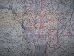
This is from a privately-published map (the other side showed downtown in great detail) listing the bus lines in DC, and the same company's bus services in parts of Montgomery and Prince George's County.
There was no date on the map, but it does show the 20 streetcar line having been converted to bus, and that happened in early 1960. Since it still shows other streetcar lines, we know the map dates before 1962, when all the remaining lines closed.
With some exceptions, the same bus (and the numbered streetcar lines were replaced by bus routes bearing the same numbering system) routing structure is in place today.
I do see that there was also a busline in my neighborhood on 3rd Street and there isn't today. Even in 1960, getting to work by transit, especially downtown, was typical. This didn't change until later in the 1960s.
What would be interesting to see is a bus map later in the 1960s, as well as in say 1976, after the subway system started its operation, and presumably afterwards the bus system and routes were "rationalized" in response.
posted by Richard Layman @ 9:10 AM&Permanent Link
![]()
![]()


0 Comments:
Post a Comment
<< Home