Missing the point about sidewalks: it's not about sidewalks, it's about walking
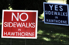
Post photo by Mark Gail.
In response to the Post Extra article, "District's Move for Sidewalks Divides NW Neighborhood of Hawthorne," I say that having sidewalks everywhere isn't the issue when plenty of people aren't walking where there are already exists a virtually complete network of sidewalks.
After all, DC has some of the highest childhood obesity rates in the region. See this story, "D.C. Children Top Obesity" from WJLA-TV from 2007, and this recent Washington Post story, "D.C. Area Schools Need to Do More to Address Childhood Obesity." DC must already have the most extensive sidewalk network in the region, so why doesn't it have the best fitness rates? I know, part of the issue is nutrition, etc., but the basic point obtains: it's not just a matter of physical infrastructure.
Getting worked up about having sidewalks in North Portal Estates is a distraction. Sure there are places in parts of the city distant from the core where there are gaps in the sidewalk network, even in places with a more traditional grid pattern of blocks and streets without curb cuts for garages. And it makes sense to complete the sidewalk network.
However, we should be more concerned about the plenty of places in the city where there are sidewalks and people for the most part aren't walking. It's a matter of priorities and of figuring out the whats and whys (related to the point I made yesterday about focusing on the right things and asking the right questions, rather than avoiding the obvious).
In the paper/blog entry "Ideas for making bicycling irresistible in Washington DC," one of the sections is on promoting bicycling specifically at the ward/neighborhood level. Think of these points and add the word "walking" and you have a framework for bicycling and walking planning and programming at the neighborhood level:
Ward/Neighborhood bicycling enhancement
• Rate all neighborhoods in terms of their capacity to support bicycling including topography, distance to amenities and other destinations, location of schools and parks, etc. (Could use DCOP’s 37 planning areas for the organizing framework for this activity.)
• Create (relatively simple) subplans of the Bicycle Master Plan for neighborhoods-ANCs-Wards and develop programs to enhance bicycling within neighborhoods based on this assessment. Create programs that are fine-tuned to local conditions, rather than one-size-fits-all programs that will fail if implemented in places with unfavorable conditions.
• Create focused programs to engage demographic segments under-represented in the ranks of bicyclists: children; families; disabled (
• Ensure that bicycling promotion programs provide information, focused outreach, and assistance to various ESL demographics.
• DDOT and DCOP have ward planners. (And DPR has Ward coordinators for
• Develop stronger civic engagement/volunteer programs. Non-government employee bicyclists can serve as “ambassadors,” mentors, and “buddies” to move people along the path from occasional rider to daily bicyclist.
• Community-neighborhood cycling enhancement grants (
• Annual neighborhood and/or ward rides, comparable to BikeArlington and
• Create neighborhood bicycle tours with online and printed maps. Partner with DestinationDC and CulturalTourismDC to do this.
Each neighborhood needs a walking and bicycling plan, and there needs to be a "neighborhood trail" for walkers and bicyclists that links civic assets such as parks, schools, recreational centers and libraries, with neighborhood commercial districts and other institutions, and transit stations, in a manner that extends the idea of "Safe Routes to School" to walking-bicycling routes within neighborhoods.
The neighborhood walking-site-asset maps program in Seattle implements this kind of idea. From the Feet First website:
Why Maps?
At Feet First, we see maps as ways to both celebrate and transform your neighborhood. We work with people from all walks of a community to publish our Neighborhoods on Foot series. In each community, we find that people identify with where they live and have passionate ideas of how to shape the future.
Neighborhoods on Foot Series
Our "Neighborhoods on Foot" maps are periodicals -- in them you can read about important current events, up and coming groups, or how to put your finger on the pulse of the community. We reissue them with local support and participation. The cover side is rich with content that will increase your community quotient.
Maps can be picked up in the neighborhood for free from a primary location and many shops, cafes, libraries, and community centers. You can always find them at our office.
The WalkArlington program in Arlington County is another program, one that uses branding and social marketing techniques to tie together planning activities that promote pedestrianism along with practical programs (some in association with Fit Arlington) that promote exploring neighborhoods via walking. (And Arlington does this with biking too, see BikeArlington.) From their website:
Urban planners, sociologists and others have long looked at the factors influencing walkability. The biggest factor affecting a decision to walk is distance. Most people are willing to walk a quarter to a half mile. A few people are willing to walk greater distances. Arlington's planning for pedestrian travel has built on this principal. Providing higher densities and pedestrian facilities within this walk zone around Metro stations has made Arlington a national leader in transit oriented development.
In Arlington, the goal IS a walkable community, and WALKArlington is the name of the primary initiative to make it so! An inter-disciplinary, cross-cultural citizen and staff-driven effort, WALKArlington is part of an even bigger plan to realize Arlington's intrinsic "urban village" nature, where goods and services and other needs are located close to one another and to residences and workers, and where walking is simply the safest, healthiest and most enjoyable way to get around.
People are willing to walk farther, every day, when the place environment is congenial. We see this in areas of the city with a continuous and active street environment, and so people walk farther distances than the norm to get to work (i.e., walking from Adams-Morgan to downton) and other places.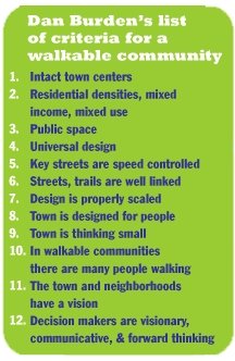
But the basic point is this: sidewalks aren't enough--it's about the broader environment and programming to help people take that first step, when they are much more accustomed to driving. See this Post special series for more, "Young Lives at Risk: Our Overweight Children."
Also see this piece by Dan Burden, "How Can I Find and Help Build a Walkable Community?.
Now I could have taken an urban design approach to this entry, but for the most part, the right urban design is in place in DC for walking, at least in a large portion of the city. For a couple of papers along those lines see:
-- (published by the Florida Department of Transportation) Walkable Communities: 12 Steps for an effective program
-- Close Encounters with Buildings by Jan Gehl et al.
And Planetizen has a nice piece on what I prefer to call guidelines to complete places, but are technically "street design" manuals. See "Rethinking the Street Space: Why Street Design Matters." It lists a number of links to quality street design manuals.
Labels: public health, sidewalks, transportation planning, walking
posted by Richard Layman @ 10:34 AM&Permanent Link
![]()
![]()


0 Comments:
Post a Comment
<< Home