With "transit-oriented development" urban design and/or planning is destiny
There are (at least) two reasons to build fixed rail transit lines: to improve transit thereby reducing traffic congestion and improving mobility and accessibility; and to improve (revitalize) communities.
Unfortunately, "improving communities" isn't really part of the criteria used by the Federal Transit Administration in deciding upon what projects to fund.
The biggest lesson that all transit planners from around the country can learn from the WMATA system--the fixed rail subway system in the Washington DC Metropolitan region--is that if you want to reap extranormal benefits from the addition of transit, you need a system of connected lines and a density of stations. One line doesn't do it. That's the key difference in all of the systems constructed from 1960 forwards.
For example, the BART system in the San Francisco region has about the same amount of trackage as WMATA, but half the number of stations. Part of this is because San Francisco has its own system of fixed rail transit (streetcars). But for cities like Oakland to have truly benefited from the addition of fixed rail transit to their region, there needed to be the addition of a fuller array of complementary transit/subway stations within the city, comparable to San Francisco's MUNI system.
The lesson from Portland, Oregon is that adding modes, such as streetcars, to a system of light rail and buses, improves mobility and accessibility and development opportunities. That's the difference between Oakland, California and Portland, Oregon.
The WMATA system wasn't designed so much to improve the city of Washington as much as it was to make getting to and from the city easy for commuters moving out of the city but still working in the Central Business District and in federal government installations located in the city.
But putting stations in places for suburbanites to get to work also benefited the in-city residential areas that had high quality building stock, a pedestrian-centric urban design, and a reasonable amount of population density.
DC has 40 subway stations, and in the core of the city where these lines overlap, there are 29 stations, about 2 per square mile, and getting around is fairly efficient.

29 subway stations at the core of the city of Washington make up the "monocentric" portion of the WMATA subway system. (Note that this map includes Fort Totten, which isn't included as part of this analysis.)
But in the outer parts of the city, where the remaining 11 stations are located, in areas lacking the same kind of population and building density enjoyed by the core of the city, with a more spread out pattern of spatial development that is more automobile-centric, the neighborhoods haven't improved the same way as they did in the core of the city.
You can say this is because the neighborhoods are in the eastern part of the city, the "unfavored quarter," sure, but I think this is due in large part to the spatial patterns present there and the failure to agree to re-work some of the land use plans back then to leverage the addition of fixed rail transit.
OTOH, note that there was a goodly deal of opposition to this, particularly in Takoma Park, and if it would have happened then, likely it would have been butt ugly, because urban renewal modernism was the prevailing redevelopment paradigm back then (actually, the subway is an urban renewal strategy as well).
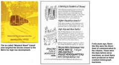
Images of a protest flyer and the cover of a station area plan for the Takoma subway station from the article "Call to Arms: Activists defend a community under seige" by Diana Kohn, in the May 2009 issue of the Takoma Voice.
Think the hulking development of Fort Lincoln on Bladensburg Road in DC, not something reasonably attractive, like the condominiums-apartments currently being built abutting the Petworth Station on Georgia Avenue. (Although most of the new development at Fort Totten Station, one station up, does qualify as butt ugly.)
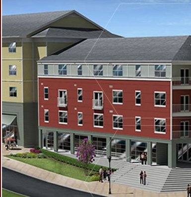
Rendering of construction at Fort Totten.
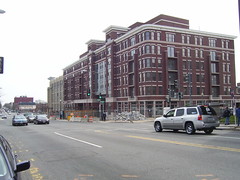
Apartments-condominiums being built across from the Petworth Metro Station, Georgia Avenue
Greater Greater Washington writes about Prince George's County and its failure to fully leverage subway station access, in "Prince George's totally missing the (train) boat." The entry fails to consider Prince George's County's urban form and spatial patterns and the historical placement of stations.
The reality is that PG County doesn't have a subway system, they have four stubs of three lines with 4 green line stations on each of two stubs north and south, 4 blue line stations, and 3 orange line stations. (Two of the stations, Southern Avenue and Capitol Heights, are on the DC-Maryland border, although located within Maryland.)
Unlike Montgomery County, which created a complementary bus system to link people and places to the subway lines, PG County has never developed a comparable bus system.
Plus, Montgomery County possessed more densely developed neighborhoods, even if "suburban," in a goodly portion of this area, making it easier to leverage the benefit of additional transit through having 13 subway stations on the east and west legs of the subway system. (Friendship Heights is in DC, but on the border with Maryland, with one entrance in Maryland. Takoma is located in DC but borders Takoma Park, Maryland in Montgomery County. It is a major hub for the Montgomery County RideOn bus system.)
The Purple Line will be a great addition for PG County, because it will connect two of these stubs, and add 10 light rail stations (one, in Langley Park, will be shared with Montgomery County, as it is right on the border of the two counties) to their transit network, and will provide people with a way to move around part of the county via fixed rail transit without having to travel to Washington DC and back in order to do so.
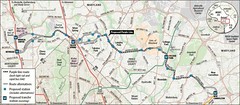
Purple Line map, Washington Post image.
But for Prince George's to fully realize the improvement this will bring, they need to initiate a continuation of the Purple Line from the New Carrollton station to the eastern end of the blue line and the southern end of the Green Line, and even across the Wilson Bridge to Alexandria Virginia.

Sierra Club image.
The other thing that needs to be done is that DC needs to reconsider how it did planning for streetcars earlier in the decade, and consider not just intra-city transit improvements, but transformational improvements in the connectivity to and from DC from Montgomery and Prince George's Counties in Maryland* to and from, and how to utilize surface fixed rail transit primarily (light rail and streetcars, note that the previous iteration of the DC Transit Alternatives Analysis only considered streetcars and bus) to improve connections between the region and to reduce traffic congestion especially on major routes into the city from these Maryland counties (i.e., Wisconsin Avenue, Connecticut Avenue, Georgia Avenue, Michigan Avenue-Queens Chapel Road, Rhode Island Avenue, H Street NE, Pennsylvania Avenue, South Capitol Street, etc.).
Note that this shouldn't preclude some expansion planning for heavy rail. Imagine DC's idea of a separated yellow line has some opportunities to improve transit connections in Montgomery County's Colesville Road/Georgia Avenue corridor.
* The original study did include connecting to the Silver Spring subway station, and a connection to National Harbor in Prince George's County. But the scope of the project was mostly focused on intra-city transit improvements, not significantly reducing traffic to and from DC. Also note that improved connections between PG and Montgomery Counties isn't a matter of concern for DC transportation planning.
At the same time, Prince George's County needs to rethink how it does infill development in response to such changes and improvements in its transit network.
Labels: neighborhood-based transportation planning, transportation planning, urban design/placemaking, urban revitalization
posted by Richard Layman @ 12:45 PM&Permanent Link
![]()
![]()


0 Comments:
Post a Comment
<< Home