Rebuilding Place in the Urban Space

"A community’s physical form, rather than its land uses, is its most intrinsic and enduring characteristic." [Katz, EPA] This blog focuses on place and placemaking and all that makes it work--historic preservation, urban design, transportation, asset-based community development, arts & cultural development, commercial district revitalization, tourism & destination development, and quality of life advocacy--along with doses of civic engagement and good governance watchdogging.

Monday, March 02, 2015

Parking districts vs. transportation/urban management districts: Part three, jitneys/shuttles/delivery and the tertiary transit network

In my conceptualization of how to do multi-faceted and integrated transportation planning and service provision at the metropolitan and regional scales (past blog entry), service delivery is categorized at four scales:
  • regional -- such as between Baltimore and DC
  • metropolitan -- foundational services,  usually heavy rail and in-area commuter rail services, serving as the backbone of metropolitan transit service, serving both the center city and the suburbs
  • suburban primary, secondary, and tertiary transit subnetworks
  • center city primary, secondary, and tertiary transit subnetworks.
The center city primary network is comprised of the intersection of the inter-city transit and a dense transit station footprint within the city (also see "Making the case for intra-city (vs. inter-city) transit planning"), while the secondary network is comprised of cross-city bus services and outer city transit stations and is more focused on within-city transit (the "intra-city" piece is more about how to conceptualize service within central business districts of various types).

Port Phillip Community Bus Stop
Port Philip in Australia has a similar bus service.  Their bus stop sign is a good illustration of the purpose of the service.  Flickr photo by Daniel Bowen.

Conceptually, the neighborhood serving element of the tertiary network would provide a means for people to get from home to the neighborhood commercial district, transit stations, supermarkets, etc. without feeling compelled to drive.  See the past blog entry, "DC transit network."

That form of intra-neighborhood transit is different from more typical shuttle services that we are familiar with.  In DC most of these services travel between transit stations and a final destination.

Image from Subway Nut.

There are two types of tertiary transit service, public and semi-public.

A fully public version of this type is the free community bus service provided by Tempe, Arizona and their Orbit bus service. (Scottsdale modeled a similar service after Tempe.)  Most of the routes end Downtown at the main transportation center, which is also a stop on the Phoenix light rail rail.

Semi-public services are services that limit use to people with a relationship with the sponsor of the service, usually as workers or students or clients--e.g., federal government agencies, universities or the Washington Hospital Center all have shuttle services--linking multiple sites of the organization or connecting a building or campus to transit stations and other activity centers.

A variant would be hotel shuttles, which pick people up at airports and train stations and take them to the hotel, and will drop guests off at various places.

There are a couple of examples of intra-neighborhood focused public services like how I hypothesize, in the DC area, but both are fixed route with fixed stops.  By comparison the Tempe Orbit service will let people off anywhere along a route.

The Town of Friendship Heights, just over the DC border in Montgomery County, Maryland does provide a neighborhood-based shuttle connecting the towns apartment and condominium buildings with the Friendship Heights Metro Station and the area's two supermarkets.

The City of Vienna, Virginia provides bus service, called CUE, between the local transit station, the town center, and the George Mason University campus.  Falls Church had a similar service, but it shut down in the face of low ridership and loss of grant funding ("Falls Church to end George bus service amid grim budget," Washington Post).

DC TMDs could provide intra-neighborhood shuttle services.  In the previous discussion which outlined the case for why the city ought to create more formal "transportation management districts" to manage and support sustainable mobility, providing this kind of shuttle service would be another way to support commercial districts served by TMDs without having to focus on the provision of private parking.

Jitneys.  Jitneys or shared taxi service are a variant of this type of service.  Usually they are provided when the number of riders is too small to support regular transit service, but there is still a demonstrated need, proximate transit stations, etc.  (This will be discussed tomorrow in an entry that discusses, among other topics, Bridg.)

Labels: , , , ,

Tuesday, August 26, 2014

Transit: access and support of urban lifestyle vs. speed

Streetcar service is coming to DC. Really. Seeing three streetcars in testing phase yesterday on H Street NE finally convinced me that sometime within the next few months, the streetcar will go into revenue service in DC, only 11-12 years since the beginning of planning in 2003.

But it is happening on H Street/DC "this soon" only because former ANC6A Chairman Joe Fengler organized a campaign to get DDOT to agree to include rail installation as part of the previously approved streetscape upgrade.

Without the rails on H Street as a goad, there would be no streetcar service...

Complaints that streetcars in mixed traffic are a waste.  But it reminded me of the recent discussion about how streetcars in mixed traffic "are a waste."  See "Meet the worst transit project in America" from Vox and how the conversation is misguided, because it's asking the service to answer a different question from its purpose.

Access versus speed.  And in thinking about the photo, I realized that my writing on the same topic, "Making the case for intra-city (vs. inter-city) transit planning" should have referenced the University of Minnesota "Access to Destinations" research project from a few years back.
What is accessibility?
Accessibility is the central organizing concept of the Access to Destinations Study. In the context of transportation studies, accessibility refers to the ability of people to reach the destinations they must visit in order to meet their needs, and desire to visit to satisfy their wants.

Working, shopping, education, and recreation are just some of the human activities that motivate people to travel to a variety of destinations. The ability to reach these destinations is affected by many factors, including the transportation infrastructure, travel behavior preferences, patterns of land use and development, availability of mass transportation services, and traffic management policies. Understanding how these factors interact to affect the lives of urban and suburban residents is a major goal of the Access to Destinations Study.
The point is that access to places can be just as important or even more important than how long it takes to get there.

Don't get me wrong, I like speed too.

But the point of streetcar service is to support urban living--living close to work, shopping, parks and other amenities, and having a number of non-automobile methods to get there--walking, biking, various forms of transit, car sharing, etc.

It's not to move you long distances, where speed matters.

Image from the WCBS-TV story "State Lawmakers Give OK To 25 MPH Speed Limit For New York City."

Sustainable mobility policy and practice requires a wide range of changes to existing practices.  I have been thinking about this too in terms of how the city talks the talk about sustainable mobility, but so many of our policies and practices don't support it fully, ranging from
  • the failure to take bike theft seriously
  • the fact that traffic accident analysis favors the motor vehicle over pedestrians and bicyclists
  • that the city raised speed limits on many arterials--albeit out of the core--rather than lowered them, as NYC just did on Broadway, which required the passage of a new law by the State Legislature authorizing New York City to have posted speed limits under 30mph on arterials (Broadway Is Reined In by a Lower Speed Limit"," New York Times)
  • how NYC has introduced "Neighborhood Slow Zones" of 20mph in neighborhoods
  • etc.
Dedicated transitways for buses especially are perhaps the next major step for urban transit systems.  Arlington and Alexandria have just launched the first phase of the Metroway transitway.  Service started Sunday ("Metroway, the region’s first bus rapid transit, to debut in Northern Virginia," Post).  I'll have to get out there to check it out.

-- Metroway webpage

Vicki Hallett wrote in the Express about how the city needs to up its committment to transit through dedicated transitways ("Lane excuses: Buses deserve dedicated space"). I definitely agree.

Labels: , , , , ,

Thursday, February 20, 2014

Agenda setting: snow clearance in the walking-biking-transit city

Right:  Every year DC's Department of Transportation runs a public service ad campaign imploring people to shovel their sidewalks.  This is from the 2013-2014 campaign.

GGW has an entry ("Joseph Brown died trying to avoid a snow-covered path, and DC blamed him for it") about the death of a person who, unable to walk on the sidewalk because it was full of snow cleared from the roadway, was crossing Sousa Bridge while walking in the roadway, and he was hit and killed by a car.  Technically, he was at fault for walking in the roadway.

This kind of event happens every year during major snows.  People walk in the street because sidewalks, especially those under direct responsiblity of public agencies, aren't cleared.  And some die.

I don't understand why there isn't a greater attention to creating what I call a "maintenance of way" agenda in the walking-biking-transit city that supports winter-time mobility as well as fair-weather mobility.

In response to recent snows, there are some letters in the Post about this ("Area government’s snow hypocrisy") and Montgomery County Councilmember Hans Riemer has proposed better snow clearance practices for the Silver Spring and Wheaton Urban Districts, based on practices in Bethesda ("Riemer wants to look at snow removal in Silver Spring," Gazette).

The concentric circles on this map represent 1/4, 1/2, and 3/4 mile distances from the Metro Station.

This is the agenda I came up with in 2010 (note that #7 has been added with this update, and old points #7 and #8 have been re-ordered):

Proposed agenda for snow removal policies that support walking, transit, and bicycling, in a city where upwards of 40% of households do not have cars, and where as much as 51% of trips to work are captured by walking, bicycling, and transit:

1. The city needs to develop a plan for "maintenance of way" so that citizens can get to schools, libraries, transit stops, transit stations, and local commercial districts, regardless of snow conditions. This is especially necessary for the one mile radius areas around subway and train stations.

2. And the city needs to adopt specific policies and practices with regard to snow removal from the sidewalks of city properties. Too often, snow is inadequately removed from the sidewalks of city properties such as parks, libraries, and schools. The city government itself should set the standard for preferred practices on snow removal.

3. And the city needs to adopt specific policies and practices with regard to snow removal from bus stops as well as from bicycle trails that are also used for transportational purposes.

4. And the City needs to work out an agreement with the National Park Service for snow removal on NPS parcels (park space and other land reservations) that have sidewalks and are integrated into the city's urban fabric.

5. To maintain the economic vitality of the Downtown, which is the primary economic generator within the city in terms of tax revenue generation and maintains the city's place as a key center within the regional economy, the city needs to have a plan to deal with snow removal needs there, and in the other major employment centers in the city.

6. The city needs to prioritize snow removal on bus routes, so that even if the aboveground transit stations are closed, WMATA could still run, safely, bus service on most of the routes. (Some routes, such as the G8, which goes up a big hill on Eastern Ave., likely would have issues.)

7.  The city needs to be sure that alley residential communities are not ignored when it comes to snow removal.  While the city does not normally provide snow clearance service to alleys, this practice should be applied differentially, depending on whether or not there are domiciles.

8. Overall, this means that the city government needs to do a better job in terms of maintaining and provisioning equipment, and addressing the needs as they arise.

9. Furthermore, WMATA needs to develop a better program for maintaining bus service in high snow situations, and providing "snow emergency" bus service connecting closed above-ground transit stations to the working underground system.

Even when it snows, in a transit city, people should not be denied transit.


The City of Fairbanks, Alaska just got a new sidewalk plow, according to the Fairbanks News-Miner newspaper.  

DDOT has a piece of equipment about this size for bike trails.

Alley communities.  Separately I have written about servicing alley housing, which often might require smaller equipment--such as smaller fire trucks and garbage trucks. (DC does have a set of smaller garbage trucks, but I haven't seen alley sized fire trucks.)

Note that it has been reported to me that the city is also remiss in often not doing snow removal in alley communities.  The need to address this has been added to the overall agenda.

Photos:  Gessford Court SE via Facebook.

It's not just a matter of self-organizing I don't think,  because there is still the issue of clearing snow from the section between the alley and the outside streets.

I didn't take photos, but over the weekend in Moorefield, West Virginia, in the small commercial district which is also the county seat, they were shoveling the snow into the street, picking it up with front loaders, depositing it into dump trucks, and removing the snow from the area altogether.

Similarly, while Winchester, Virginia declared a snow emergency, which meant that parking on the street or in parking lots in Downtown was forbidden, according to the Winchester Star the city allowed free parking in parking structures. 

Labels: , , , , , , ,

Monday, December 30, 2013

Flashy one-offs vs. a program: the proposal for an 11th Street bridge linear park and the rest of the city

From Washington Present and Future: A General Summary of the Comprehensive Plan for the National Capital and its Environs (National Capital Park and Planning Commission, 1950):


Washington is a beautiful city because of its Mall, its parks, and the river.  Yet in spite of these, the bulk of the inner residential areas are quite ordinary and certainly not beautiful.  One redeeming feature of these sections is that street trees hide the ugliness.  Beauty that exists must be preserved and enhanced.  In the course of the improvement program laid out by the comprehensive plan, new beauty should be created.

-- Chapter: "Setting for Democracy; section: Civic Art; p. 41.

--------------------------------

The Bilbao Effect and civic undertakings elsewhere.  Earlier in the week I wrote about Bilbao and the misperception that Bilbao doesn't have a revitalization program but has relied on a flashy building, the Guggenheim Museum Bilbao, designed by Frank Gehry as a kind of metallic public sculpture and work of art, to attract attention and revive the city.

Wikipedia photo: Guggenheim Museum Bilbao.

While it is true that the GMB has been a significant element of the city's program of rebranding,  repositioning, and revitalization, the reality is it is only one of more than two dozen major actions, totaling billions of dollars of investment, that Bilbao and the provincial, regional, national and EU governments have undertaken there, starting in the mid-1980s.

But that hasn't stopped other cities across the globe from trying to apply what they think is the "Bilbao Effect" by constructing a flashy cultural building of their own.  Mostly they fail, because the Bilbao Effect is a program, not a one-off project.

High Line before.  New York Times photo by James Estrin.
 
New York City's High Line as another flashy project that other cities aim to copy. 

Our next door neighbors have a five-year-old child who has a bunch of younger cousins--Marina constantly complains that her cousins "keep copying me" while not acknowledging that she in turn copies her older cousin and her schoolmates.

What we might call the "High Line effect"--how in New York City a piece of industrial infrastructure, in this case an elevated freight rail line, was converted it into a linear park (pictured at right) which has helped to bring renewed attention and investment to the Chelsea district--is similarly being adopted as a tactic in other cities, without their understanding that the success of the High Line project is more complicated.

Success has been dependent on the fact that the  infrastructure is well located and can be  integrated into the existing street fabric in an area of the city that possesses a great many real estate development opportunities, in a strong real estate market, in a city where it is possible to raise a great deal of money philanthropically, paired with an implementing organization and ongoing program of activities.

In short the High Line's success derives from multiple elements:

- industrial infrastructure
- that is well located and placed and adjacent to population and therefore capable of being well-used
- and already somewhat integrated into the urban fabric
- with a program for repurposing
- the potential for funding
- the ability to generate spillover development
- plus being located in a hyper-strong real estate market.

One element of the High Line public art program is a billboard, featuring somewhat challenging work.  Billboard left by Allen Ruppersburg.  Image from  "Here’s the New Allen Ruppersberg Billboard Along the High Line," Animal New York.

People approach the High Line story simply--repurposing a piece of industrial infrastructure--and the circumscribed understanding of the "High Line Effect" may be just as dangerous as lack of knowledge about what the "Bilbao Effect" really is also. 

It also is criticized as an element of touristification ("Disney World on the Hudson," New York Times).  From the op-ed:
The High Line has become a tourist-clogged catwalk and a catalyst for some of the most rapid gentrification in the city’s history. My skepticism took root during my first visit. The designers had scrubbed the graffiti and tamed the wildflowers. Guards admonished me when my foot moved too close to a weed. Was this a park or a museum?
Note also that area residents did not vote in favor of creating a special services and tax district to help fund park operations ("High Line Park Stewards Hoping for Neighborhood Tax," New York Magazine; "High Line plan is too taxing, neighbors cry" The Villager; "High Line Backs Down," Architect's Newspaper).

In 2011, the park had 3.7 million visitors and according to surveys and extrapolation, half the visitors were New Yorkers and the other half tourists.

Wikimedia image of the High Line.

Similar projects being pursued around the country include the Beltline in Atlanta, the 606 in Chicago, the Trestle in St. Louis, the Rail Line Park in Philadelphia, the Cumberland Valley Railroad Bridge in the Harrisburg, PA area, a project in Evanston, IL ("Evanston's own High Line Park -- for $19.5 million," Evanston Now) and undoubtedly others--frankly rails to trails projects have been the precursor to such projects and have been underway for decades.

There's an underground park project in NYC called the Low Line ("Considering an Underground Park in New York," Wall Street Journal), while there has been talk of a similar kind of project at Dupont Circle in DC for years.

DC's 11th Street Bridge Linear Park proposal.  I am into bold projects like the High Line that involve the repurposing of transportation infrastructure and the creation of linear (and other types of) parks and trails, etc.

So I find the idea that the DC Office of Planning has put out there, to recapture the now de-accessioned old 11th Street bridge for a park, cool and interesting and seemingly worth pursuing.

According to the latest Washington Post article on the concept, "D.C.communities split by the Anacostia could become closer in plan for first elevated park," now it's being pursued as a private initiative looking to raise $35 million to pull it off.

Of course, usually such bridge recovery projects--mostly repurposed into pedestrian bridges such as in Chattanooga (the 1891 Walnut Street Bridge was preserved as a half-mile-long pedestrian bridge) and across the Hudson River (the Walkway Over the Hudson, the former Poughkeepsie-Highland Railroad Bridge was transformed into a 1.28-mile-long state park) don't require that you tear down the bridge platform and rebuild it so it's safe--that's a kind of spurious cost that almost makes the 11st Street bridge park proposal a project not worth pursuing. 

Plus, while the sentiments behind the project are particularly appealing in terms of equity and political correctness--let's connect "East of the River" (it's really south of the Anacostia, but...) with the Rest of the (Richer) City--the problem is that unlike the High Line, one end of the bridge, in Capitol Hill, isn't located within residential districts, and the other end, in Anacostia, is somewhat disconnected from residential precincts as well.

So the project could be great, or it could prove all of the points made by Jacobs in Death and Life of Great American Cities about how parks can be dead spaces, because of how they may be situated away from population and/or activity centers, and as kind of a variation of why "pedestrian malls" tend to not work except in very specific situations (see "Now I know why Boulder's Pearl Street Mall is the exception that proves the rule about the failures of pedestrian malls"), they fail.

Right:  the original Truxton Circle, which was located at the intersection of Florida Avenue and North Capitol Street.

Why isn't there more focus on improving our existing places?  But these reasons, as important as they are, aren't even what bugs me about the proposal.

I understand that people are into flashy.  But why not focus equally on urban design projects that may either be more easily realized and/or have significant places that already exist?

It's low hanging fruit, albeit the projects may still bel expensive, but not always, such as parklets.

The failure to address the many neglected opportunities across the city to reknit the scars created by a pro-automobile public space policy and/or improve streetscapes and placemaking opportunities in exisiting places is aggravating.  I have written about this a lot already, in pieces such as these:

-- Complete Places are more than Complete Streets
-- What a "Complete Places" land use and transportation planning philosophy would mean in practice
-- Public Squares and DC
-- It's time for a new "city beautiful" movement in DC

And more recently in
-- DC's bad urban design as it relates to new transportation infrastructure
-- The layering effect: how the building blocks of an integrated public realm set the stage for community building and Silver Spring, Maryland as an example


Right: Divisadero Parklet - San Francisco - Jeremy Shaw, Vancouver Public Space Network, Flickr photo.

Certainly, the way that New York City has pedestrianized areas along Broadway and in Times Square is one example of an alternative approach.

Another are the various parklet programs now spreading across the country (but not in DC), which started  as a guerrilla initiative by the Re:bar group in San Francisco and later was taken up as an officially sanctioned program by the San Francisco government, and has since been copied by other r cities across the US and Canada.
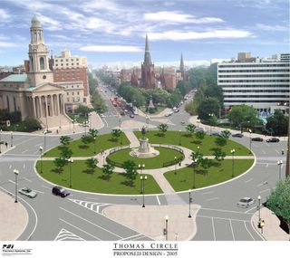
Thomas Circle Reconstruction, Washington, DCIn 2005, DC's Department of Transportation restored Thomas Circle to its original configuration.  In the 1950s, part of the park had been cut away in favor of more traffic lanes.

We have plenty of urban design opportunities across DC where we could make the streetscapes better and either create or re-create or improve neighborhood centers.

But we keep ignoring the chances we have or we are deliberately not choosing to do so.

Here are some places that could be significantly improved (of course there are many more):
  1. the re-creation of Truxton Circle at North Capitol Street and Florida Avenue NW
  2. decking over the North Capitol underpass--instead in a recent plan by OP and DDOT they punted the responsibility for initiating this to the neighborhoods
  3. decking over the Connecticut Avenue underpass at Dupont Circle
  4. restoring Dupont Circle to its original size by taking back the inner traffic lanes and making them park (this was done for Logan Circle in the 1970s and for Thomas Circle in 2006, note that Grant and Sherman Circles in Upper Northwest DC retain their original configurations)
  5. creation of a better Scott Circle (something that Dan Malouff at Beyond DC blog suggested a couple years ago)
  6. restoration of the original sidewalk configuration on the east side of Connecticut Ave. NW in Cleveland Park
  7. creating tunnels for through-commuter traffic for New York Avenue and parts of North Capitol Street and Blair Road (see "Tunnelized road projects for DC and the Carmel Tunnel, Haifa, Israel example")
  8. creating a circle at Georgia and Missouri Avenues NW
  9. creating the so-called "Brookland Green" as an element of repositioning Brookland around a new town center district centering on the Metro Station (see "Brookland neighbors ask Metro for development with a side of green" from GGW)
  10. creating a great park as part of the McMillan site redevelopment, instead of being happy with what's being proposed by the developer (see the commentary in this entry "McMillan plans show expansive new recreation spaces" from GGW--the entry is happy with what's being proposed while certain commentators, including me, think it could be a lot better).
Monument Avenue, Richmond.  Flickr photo by Hickydoo.  Note that the street consists of asphalt block, which provides visual, physical, and aural cues to drive more slowly.

11. Plus my point that pavement in commercial districts and around circles and squares and schools should be converted to Belgian Block to better reflect the pedestrianized nature of these places (see "It's all relative: conditions shaping road speeds and safe, comfortable places").

DC is good at one-off projects and bad at developing bold and systematic approaches to neighborhood public realm improvements.  I am ecstatic with the incredible new parks and places that have been created in the city over the past 8 years or so, in particular the reconstruction of Thomas Circle, the creation of the Columbia Heights Pedestrian Plaza, the Georgetown Waterfront Park, the Yards and Canal Parks in the Capitol Riverfront District, along with various streetscape improvement projects on avenues and in commercial districts.

But for the most part these are one-off events that haven't been harvested as learning that feeds into a more comprehensive program.  There isn't a systematic program for improving the urban design quality of the city and its neighborhoods--unlike in cities like New York City and San Francisco, even though arguably, DC started to implement similar improvements much earlier.

Resources from the Project for Public Spaces


North Capitol Street underpass.  Flickr photo by carfreedc.

North Capitol Street Corridor in Mid City.  As an example, the DC Department of Transportation has produced a Livability Study, focused on public realm and transportation improvements for what they call Mid City East, covering an area of the city that lies between Rhode Island Avenue on the north and New York and Florida Avenues on the south.

According to the study webpage:
Collaboration with local residents, community leaders, and agency partners, focused the study on four primary objectives:
  1. Link the communities across the major arterials.
  2. Reconnect the communities to the larger city.
  3. Reclaim minor streets and corridors from commuters and restore them to community needs and character.
  4. Increase resiliency to flooding and other climactic effects.
The plan has some decent discussion on the roadway network and system and desired characteristics (frankly, this discussion would have been better had it referenced the transportation network and land use context framework developed within the Smart Transportation Guidebook used by New Jersey and Pennsylvania--one of my complaints about the current DC master transportation planning process is the failure to start with robust frameworks to guide development of each of the elements, and this includes how the roadway network and system is conceptualized in terms of local land use contexts and whether or not roadways are primarily community or regionally serving or mixed). 

The most significant factor degrading quality of life in the Mid City East neighborhoods is the way that the major arterials act as major gateways in and out of the city and enable automobile traffic to dominate and disconnect the neighborhood at the expense of quality of life.  This is acknowledged by the goals of the plan.

See the arguments about the impact of this kind of problem in Livable Streets by Appleyard and Reclaiming our Cities and Towns: Better Living through Less Traffic and Street Reclaiming: Creating Livable Streets and Vibrant Communities by Engwicht.

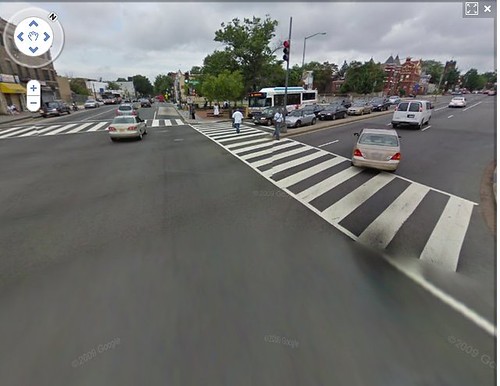
Google Street View, North Capitol Street and Florida Avenue NW, intersection
The intersection of North Capitol Street and Florida Avenue today, where Truxton Circle previously existed.  Google Streetview image.

While this was discussed in the planning process, and recommendations for improvements were made for various intersections and certain corridors, for the most part, bold solutions, such as decking over North Capitol Street even when suggested by residents, were not considered and ended up being barely referenced in the final plan.

Of course, one of the boldest ways to address the problem would be to deck the North Capitol underpass, which would be significant, expensive, and I think a greater priority than building a bridge park across the Anacostia River.  (Note that separately I have suggested that the commuter traffic on streets like North Capitol and New York Avenue should be diverted to tunnels.  See "Tunnelized road projects for DC and the Carmel Tunnel, Haifa, Israel example."  This was suggested for New York Avenue in a DDOT study in 2005.)

Similarly, restoring Truxton Circle as a way to restore neighborhood-serving qualities to the roadway network was not addressed in the recommendations either, although it was suggested that the old Truxton Circle fountain, still extant, could be installed in an area park.

According to this recounting of the process ("Plans seek to keep Mid City East affordable," GGW), the planners suggested responsibility for initiating such a program, despite its complexity, lies with the neighborhood.  (Note that it is confusing because the plan was billed as a joint effort by DC Office of Planning and DDOT but the final document references DDOT only.)

While I believe that the various recommendations in the plan will contribute to neighborhood improvement upon implementation, the most fundamental urban design problems faced by the neighborhood for the most part remain unaddressed and it remains to be seen how the overall character and quality of place will significantly improve.

In 2000, DC's new streetscape improvement program and the plan to restore Thomas Circle were at the level of national best practice.  Since then other cities have moved far beyond that level of practice, while DC hasn't moved its circa 2000 policies significantly forward.

Inspired by Millennium Park in Chicago and other large park and open space projects ("Dallas Builds Urban Park Atop Freeway Deck" from Athletic Business) Dallas is creating Klyde Warren Park, by decking over part of the Woodall Rodgers Freeway.

San Francisco and New York City (see "San Francisco Sustainable Mobility Agenda") have transformed their approaches to public space and are re-prioritizing the role of streets and public space in terms of serving pedestrians, bicyclists, and transit users, which need to be the priority in those places--like DC--where walking, transit, and biking are the dominant modes.

Another example is Dallas' creation of a park over part of a center city freeway, which has just been written up in the Build a Better Burb blog.  According to their entry:
Deck parks themselves aren’t new; the first green space to cap a freeway was Manhattan’s Carl Schurz Park, built in the late 1930s over the FDR Drive. Some twenty other parks now exist in places such as Phoenix, Duluth, MN, Seattle, and Boston, and proposals are now on the table in Los Angeles, Cincinnati, and St. Louis.
In DC, freeway decking has or is occurring in high value locations.  Part of I-395 has already been decked over for court buildings and a crappy park, as well as an apartment building on K Street NW, while separately, in an exciting project called Capitol Crossing, real estate developers will be decking over another section of I-395, in part restoring the street grid, and constructing buildings there.  See "I-395 air rights now Capitol Crossing" from the Washington Business Journal.  (I expect it will happen with the Southeast-Southwest Freeway, now numbered I-695, some time in the future also, because of the potential value of the recovered land.)

Expecting a neighborhood to initiate such a project like with North Capitol Street isn't realistic.

Columbia Heights Pedestrian Plaza.  Flickr photo by whiteknuckled.

But for the most part, DC's streetscape and neighborhood urban design accomplishments haven't gone beyond the original conception of the program back in 2000.

Even though we are adding a bunch of great new spaces, we aren't adding enough of them, and many of the new spaces fail to realize all that would be possible, were more robust planning systems in place (as discussed in the above-cited entry that addresses layering, using Silver Spring, Maryland as an example).

Note that DC planners would disagree with my assessment of current practice, and likely would argue that the DDOT Public Realm Design Manual represents best practice and the city is focused on achieving pathbreaking projects.

I would argue that the manual is good for outlining streetscape improvements, but not so much for achieving significant improvements in terms of a more robust integrated public realm and civic assets framework.
 
Conclusion.  DC needs to adopt a more robust framework for improvements to and integration of the public realm, along the lines of what David Barth of AECOM calls an integrated public realm framework.  That's the kind of citywide approach that we need.  (Note also that this includes transit infrastructure.  See "Transit, stations and placemaking: stations as entrypoints into neighborhoods.")

I don't expect that this will be done though, although it's a logical element that should be included as a section of the city's forthcoming transportation master plan, called MoveDC.

As long as the focus is on one-off projects and the flashy we will continue to limit the value we receive from the hundreds of millions of dollars that we spend every year on the city's transportation system and infrastructure.

Coordinated planning and a willingness to think big (note that thinking big doesn't always mean expensive, although it does in the case of roadway decking) would get us a lot more in the way of quality of life and placemaking improvements than we are achieving right now.
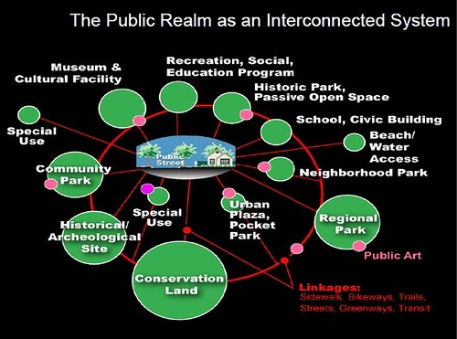
Public Realm as an Interconnected system, Slide from presentation, Leadership and the Role of Parks and Recreation in the New Economy, David Barth

Labels: , , , , , ,

Tuesday, April 09, 2013

Raising the speed limit on DC's neighborhood-serving arterials is a really bad move

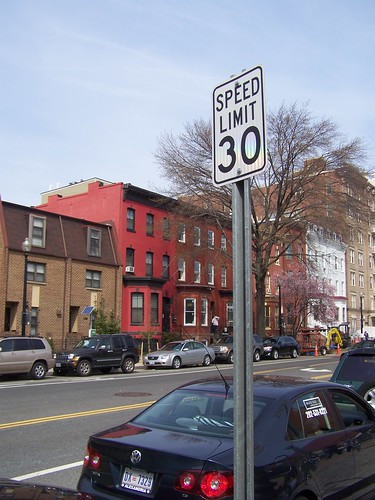
One of the elements of fallout from the recent review of the speed and traffic camera program in DC was a determination that some of the speed limits for roads are set too low.  While I understand this for true separated freeways, like "Kenilworth Avenue/DC-295," I find it particularly troubling that speed limits have generally been raised 5 mph, from 25 mph to 30 mph, on many neighborhood-serving arterials.

30 mph speed limit sign posted on 11th Street NWIn noticed this awhile back on Pennsylvania Avenue in Capitol Hill, and I noticed it yesterday on 11th Street NW (see photo, right; you can't tell but the sign is really small too, it's about half the size of a normal speed limit sign).

On upper portions of arterials such as Georgia Avenue or Connecticut Avenue, I think the speed limit has been set at 30 mph for awhile.

Ideally, the WeMove DC Transportation Planning effort would turn back that decision, by laying out pro-people transportation policies and practices.

I am a fan of the Smart Transportation Guidebook, produced by the Delaware Valley Regional Planning Council, for both NJ and PA, and adopted by the State of Pennsylvania, because it does four things:

1.  It defines roads in terms of land use context
2.  It defines roads in terms of whether they are "community" serving or "regional" serving (although sometimes roads are both, which is the issue in DC)
3.  Land use context is used to define appropriate roadway and roadside characteristics.
4.  Land use context is used to define appropriate levels for the "desired operating speed" for traffic.

----------------
P. 23 from STG

Desired Operating Speed: This is the speed at which it is intended that vehicles travel. The roadway context should play a large role in determining the desired operating speed. For example, pedestrian travel and the presence of civic uses and retail close to the street all suggest the need to use the lower range of the desired operating speed.

Roadway: The design team should select roadway elements and geometry with a clear understanding of surrounding land uses. For example, in urban areas the design team should always seek to provide parking lanes. Travel lanes are often narrower than in suburban areas, particularly if this enables the installation of bike lanes.

Roadside: The roadside primarily serves the pedestrian and the transit rider and provides a transition between public and private space. The design of the roadside elements should support the land use context. Civic uses such as schools and parks, and high density neighborhoods which generate higher pedestrian activity may require wider sidewalks.
______________

The basic point is that urban land use is typically comprised of mixed use communities like typical neighborhoods in DC, which mix commercial districts, residential districts, and civic assets like schools, parks, libraries, and recreation centers.

In such situations people walk, bike, and use transit a lot more than they may drive.

Plus, rather than concede primacy to the car, the Smart Transportation Guidebook aims to balance the transportation network's competing goals of serving regional traffic (people traveling to and from the city), throughput (ability of the traffic to move unimpeded), and local traffic (people moving in and around their community).

What that means in a city is that posted operating speeds are typically less than that of suburban jurisdictions.

But what has distinguished DC from most major U.S. cities is that the prevailing speed limit is 25 mph, not just for residential serving roads, but for major arterial roads serving as both regional roads and community roads.

In most cities, including New York City, the prevailing speed is 30 mph.  (Even though now NYC has a significant and expanding "Slow Zone" Program, which sets the speed limit for neighborhood serving streets at 20 mph.)

For a city that touts its commitment to sustainable transportation, raising the speed limit in residential places is very troubling.

Another good resource for these kinds of questions is a manual produced more than one decade ago for the State of Oregon.  Main Street: When a Highway Runs Through It is designed to help communities and the Oregon DOT to come to resolution on these same kinds of issues, balancing the needs and desires for roads serving both intra-community and regional mobility demands.

It's very interesting that Oregon law sets basic speed limits according to land use context, and while they allow 30 mph in mixed use districts, they set that as the maximum speed, acknowledging the appropriateness of lower speed limits.


SPEED ZONES (page 24)
State statutes specify the following designated
speeds (1997 ORS 811.105):
• alleys ...................................... 15 mph
• business districts, school zones when
children are present................. 20 mph
• residential districts, public parks,
ocean shores ........................... 25 mph
• rural highways, urban interstate
highways, trucks on rural
interstate highways .................. 55 mph
• autos on rural interstates ......... 65 mph

.... "At the posted speed of 30 mph, many drivers have a difficult time seeing bicyclists and pedestrians, and stopping distance is nearly twice that of 20 mph."

Re-engineering roads according to land use context

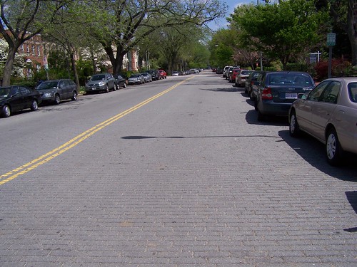
Belgian block, 900 block, South Carolina Avenue SEA couple times a year probably, I suggest that we should re-engineer road pavement type so that it is better aligned with land use context.

I make this suggestion because otherwise, roads are designed to enable very fast driving and cars (except maybe the SmartCar) are for the most part engineered to be driven very fast.  Neither works well for residential areas.

For example, the street pictured on the left is South Carolina Avenue SE in Capitol Hill.   It's comprised of asphalt block, and the pavement provides visual, physical, and aural cues to slow down.

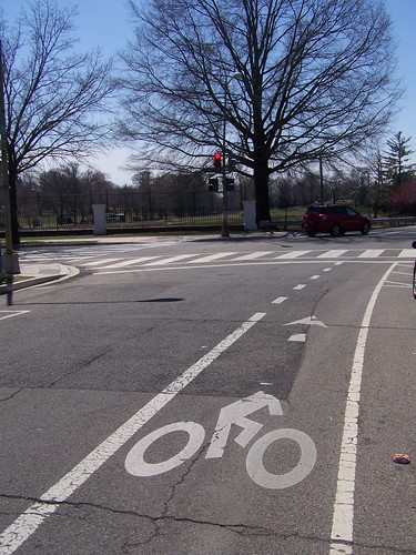
Bike lane on 5th Street NW going south, approaching the Armed Forces Retirement HomeWhen I was on jury duty, I was cycling regularly on a beautiful way to Downtown (for most of the way), along 5th Street NW south of New Hampshire Avenue (the road becomes Park Place NW and then 4th Street).

Right: bike lane on 5th Street NW, approaching the northern edge of the Armed Forces Retirement Home.

At the eastern edge of the Howard University campus, 4th Street is fronted by many dormitories (the City Paper wrote recently about how two of the former parking lots on this street are being remade as dormitories, see "Howard Will Build Two Big Dorms on 4th Street NW").

Not only should the city work with Howard University to take off at least one lane of parking so that a bike lane or cycletrack can be continued here, but the road should be re-engineered to better serve its context as a pedestrian zone-street serving Howard University students.

Like setting pedestrian-appropriate speed limits on the city's streets, the city should begin to re-engineer streets to better achieve the city's purported urban design, placemaking and sustainability objectives.
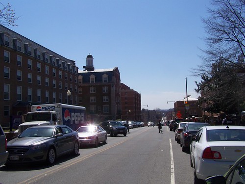
4th Street NW, south of Howard Place NW
4th Street NW at the eastern edge of Howard University

The new dorms are being constructed in sites pictured at the top left and bottom left of this photo.
4th Street NW at the eastern edge of Howard University


Labels: , , ,

Thursday, November 01, 2012

Community street mural near their local school, Knoxville

See "Branding the boulevard: Inskip mural to establish identity, slow traffic" from the Knoxville News-Sentinel.  From the article:

The design, created by former Inskip Elementary art teacher Kristie Isbell, is intended "to give Inskip an identity," said Liliana Burbano, a public health educator with Knox County Health Department. But it's also intended as a reminder to traffic that "kids are walking to school," to slow and watch more carefully. The idea for it, and the community association itself, grew out of meetings around a Healthy Kids, Healthy Communities grant the Health Department received from the Robert Wood Johnson Foundation, which helped three Knox County communities — Inskip, Lonsdale and Mascot — organize to make their neighborhoods healthier.

The story includes a video clip too.

It's also a kind of general confirmation of the point that I make that the pavements around civic assets such as schools, parks, libraries and in commercial districts, ought to be engineered to support placemaking and walkability, such as with Belgian Block.


Saul Young/News Sentinel.   Volunteers work on a large street painting at the intersection of High School Road and Mitchell Drive near Inskip Elementary School on Tuesday as part of a community-building project and traffic control feature.

Labels: , , , ,

Thursday, May 10, 2012

Committee seeks state grant to help create Towson 'Bike Beltway'

Image from the Baltimore Sun article.

This is a Baltimore County initiative, where I served as project manager for the creation of the Western Baltimore County Pedestrian and Bicycle Access plan (approved by the Planning Board in late April 2012, and now being transmitted to the County Council for final adoption) in FY10, and came up out of the Council District 5 Bicycle and Pedestrian Committee, organized by David Marks, the Councilman for that district.

It's interesting for a couple reasons.

1.  It sort of confirms my joke that I am seen as a sage in Baltimore and a crank in DC.

2.  It illustrates the "neighborhood loop" concept (for walking and biking) that I advocate for as part of sub-city transportation planning at the ward/sector/district/neighborhood level.

3.  Because the creation of BPACs at the District level, and integrated into a County-wide committee, was first suggested by me in drafts of the Western County plan.  While the recommendation was excised from the plan (probably seen as too controversial), it was recommended to the Councilman and was later re-incorporated into the legislation creating the County Pedestrian and Bicycle Advisory Committee and the various charges imbued into the ordinance.

The idea, paired with planning recommendations outputted in lists organized by Council District, rather than alphabetical, was designed to help organize advocates and advocacy at the District-level, giving them an agenda based on the recommendations, and a focus for their interactions with the Councilmember, the Department of Public Works, and other elected and appointed officials.

(I call myself a "tactile" learner.  This idea came to me after organizing an informal meeting with pizza and soda in the evening, with residents/bike advocates in the Paradise Valley/Catonsville area of the County, where we went over maps and they made recommendations, in advance of the public meeting process.)

I think only Councilman Marks has gone through with the creation of such a committee so far.  This result from the Committee's first year's work is likely to motivate more Councilmembers and the advocates in their districts, to create comparable committees.

Labels: , , , , ,

Saturday, January 14, 2012

Proposed WMATA fare increases (DC region)

Slide, Metropolitan Mass Transit Planning: Towards a Hierarchical and Conceptual Framework
Slide from my presentation, Metropolitan Mass Transit Planning: Towards a Hierarchical and Conceptual Framework.

Pressed once again to make budget projections, WMATA has proposed transit fare increases for the 2012-2013 fiscal year. See "Proposed Metro budget that would raise fares calls for hiring of 1000 workers" and "Metro board considers fare proposal, next budget" from the Washington Post.
wmata, Metro fare increase proposals
Graphic from the Washington Post.

One of the proposals is to get rid of the $9 all-day pass, which is designed to meet the needs of visitors, and instead only offer the use of temporary subway fare cards--single purchase fare cards purchased for one time use--at rates comparable to the cost of a railroad train ride, rather than a typical in-region transit trip on subway, light rail, or bus.

The rates would change to $6 one way for a trip during rush periods, and $4 during nonrush periods. By way of example, $6 is how much MARC charges for travel to DC from the BWI Airport, 30 miles away (although that fare is going up too).

This changes the pricing scheme significantly, and makes ridership uneconomic for many people, especially groups. Why pay $18-$24 for a group of four to travel one way when you can just drive? Paying for parking in a parking structure for an entire day costs about this much or less, and wouldn't trigger a similar cost driving back. Or taxi rides become more competitive price-wise, etc.

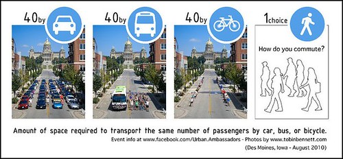
In either case, more vehicles, rather than fewer vehicles on the regions roads is the likely outcome. It's a poor use of physical space too.
Amount of space required to transport the user the same number of passengers by car, bus, or bicycle
Amount of space required to transport the user the same number of passengers by car, bus, or bicycle. Graphic from the Urban Ambassadors, Des Moines, IA. (Note that when I first acquired this graphic a couple years ago, the Urban Ambassadors didn't have a website, just a Facebook page. Their website is worth a visit.

Charging exorbitant rates to visitors is not an unusual revenue generating strategy for communities. It's done with hotel rooming taxes, rental car usage taxes, and parking structure taxes in many cities, and in DC particularly, the tax on restaurant meals--10%--is much higher than in other places, in large part because of the belief that more of the tax is paid for by nonresidents than residents.

Typically, most of these taxes are used to support convention centers, tourism marketing, and related activities, although parking taxes tend to be a general fund revenue item.

So there is a precedent for looking to tag visitors with exorbitant prices to use the subway system, which already charges more for casual users versus SmarTrip card users.

But the fundamental issue has more to do with what is the purpose of the transit system:

• Is the transit system supposed to be used to get people to and from work, ideally where the workers have subsidized transit benefits (e.g., federal government workers are eligible for free transit benefits worth about $125/month)?

• Is the transit system supposed to be used as a mobility congestion management tool to reduce traffic and the need to build and maintain more roadways?

• Is the transit system seen as an element of a community's positioning and economic development strategy, shaping land use in sustainable ways so that the need to travel is reduced by placing more activities within walking, biking, and transit distance?

• Is transit a service of last-resort, for people who can't afford to own an automobile, so high subway fares are used to push low-income riders to buses?;

• Should a fare system be developed that supports the creation of "fare zones" and passes, so that transit use is encouraged, rather than discouraged, in terms of the cost of any one trip; etc.,

and how does that influence how the system is funded, and the strategy for fare revenue management?

These kinds of issues are discussed in the past blog entry "(Sort of a repeat) Without the right transportation planning framework, metropolitan areas are screwed, and that includes the DC area."

For the region, consideration of the transit system as the primary element of civic and transportation infrastructure within the region, as the leading means for shaping mobility and land use decision making, congestion management, and for creating great places and promoting high quality of life is paramount.

Therefore, how to fund the system in a manner that the WMATA budget planners aren't forced on an almost annual basis to engage in a kind of fare-setting "legerdemain" just to come up with the necessary funds ought to be the metropolitan area's chief priority right now.

This problem isn't unique to WMATA. Most transit operators nationally have the same kind of funding desperation because of drop off in local and state funding as a result of the recession, as well as drop offs in local tax receipts such as sales taxes and real estate transaction taxes and other taxes which have been used to support local transit operations.

But WMATA does have some special circumstances.

In the face of region's loss of trust with regard to WMATA after the train crash in 2009, which resulted in the deaths of nine passengers, I recommended that the transit system and the region engage in a high profile transportation planning initiative focused on rebuilding the region's understanding of the role and primacy of transit as the main engine of growth, mobility, and prosperity.

St. Louis regional transit planning process, slide.

Other regions have/had similar initiative's such as Chicago's Moving Beyond Congestion Strategic Plan, the Go Ohio transportation planning initiative in Ohio, and Keep PGH Moving in Pittsburgh (although that campaign is more focused on obtaining state funding for the local transit system to reduce the number of cutbacks).

While people are familiar with special local tax initiatives to support transit expansion, such as Los Angeles' Measure R, clearly the DC region--DC, Maryland, and Virginia--need to consider such initiatives as a source of funds to help get WMATA onto a new track when it comes to fares and revenue management.

-- Center for Transportation Excellence, a research group that supports transit infrastructure funding and election initiatives
-- History of BART transit system, San Francisco Bay region, including discussion of how sales taxes became a source of system funding

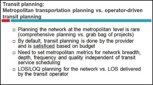
This graphic, "Traffic Trouble: How Transit Cuts Will Affect Your Daily Commute" from the Pittsburgh City Paper, is brilliant in how it communicates that transit service is vitally important to a region, and perfectly illustrates my point in the very first image above, about how Level of Service and Level of Quality decisions about a transit system are too important to leave to the transit operator, which first and foremost is driven by budgetary concerns.

WMATA needs to reposition the conversation about funding so that these kinds of desperation moves with regard to the fare structure can be avoided.

Traffic troubles, impact of transit cuts, Pittsburgh

Labels: , , , , , ,

Tuesday, October 04, 2011

Supporting car sharing vs. privileging car owners and the use of the public space

Zipcars
Flickr photo by akseabird.

DC recently decided to put up the street spaces located in commercial districts that it has dedicated to car sharing up for bid, and Zipcar, the for profit company with the largest local presence and active user base (i.e., critical mass), was outbid for most of the spaces by well-funded competitors who could also use non-market-based criteria (i.e., over-bidding beyond the economic value to crowd out their competitors).
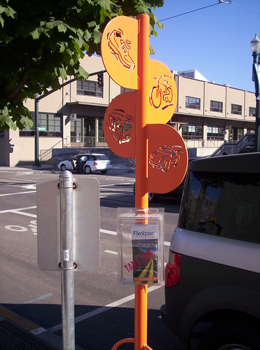
Flexcar promotion. Portland's Pearl District
Distinctive orange pole used to demark car sharing spots.

I wrote about this in "Another example of DC's failures in transportation planning: carsharing."

What that means for Zipcar users is that most of the public spaces used for Zipcars are no longer available--not only to Zipcar but to the users--and the users are people like me who are citizens of the District of Columbia.

It's not like Zipcar is significantly less convenient because of the change--more Zipcar spaces are on private property anyway.

But it does make a huge difference in terms of the cost/hour to use the car.

I could get cars from the 4th and Blair Street NW location for $7.75/hour. Now the base price seems to be about $11.25/hour for use of cars parked on private property--a difference of $3.50/hour.

If we use Zipcar about 75 hours/year that's an additional $262.50/year.

Granted some of the increase is likely due to increased costs, especially for gasoline, but still, that's a lot of money.

When the car sharing concept was first introduced, I too had some reservations about "free" (they ended up paying) use of dedicated public parking spaces for a "for profit" company.

But later I reconsidered ("High Cost of Free* Parking Revisited and Car Sharing in DC"), realizing that the issue wasn't about the for profit company benefiting as much as it was the member-users benefiting, and the overall reduction of the number of registered vehicles in DC, thereby reducing the demand for parking and car trips more generally.

Because of DC's policy change, many households will end up paying hundreds of dollars more per year to use cars occasionally.

Meanwhile, for spaces worth as much or more than $2,000/year, owners of cars registered in DC now pay $35/year for a parking permit (it was $15 for years, it just went up on October 1st). And many blocks in the city don't even have residential parking permit requirements.

I ask again, as I did in 2005, should car owners be specially privileged over car users in the use of the public space for parking?

I say no.


From the website:

Permit fees vary according to a priority system based on need as reflected below:

• No access to on-site parking for resident's first vehicle:
$13.39/month plus sales tax
• No access to on-site parking for resident's second and any subsequent vehicles:
$33.48/month plus sales tax
• Resident does have access to on-site parking (permit is for convenience):
$46.88/month plus sales tax

Labels: , , , , ,

Thursday, July 07, 2011

Planning for sustainable transportation at the neighborhood level in Montreal

Children's ideas about improving streets and neighbourhoods to encourage active transportation, like walking and cycling.
Children's ideas about improving streets and neighbourhoods to encourage active transportation, like walking and cycling. From Ecole Etoile Filante in Notre Dame de Grace on rue Notre Dame de grâce and Old Orchard Ave. Photo Credit: Ecole Etoile Filante in Notre Dame de Grace, via the Montreal Gazette.

The Montreal Urban Ecology Center has an interesting initiative, "Green, Active and Healthy Neighbourhoods," which aims to redesign neighbourhoods to promote walking, cycling, and other active transportation modes. The four pilot projects are in the neighborhoods of Mercier Extension, Plateau East, Southeastern Notre Dame de Grace, and Parc Extension.

The initiative is a true implementation of my idea to create "sustainable transportation elements" for community and sector plans, focused not just on infrastructure but also including programming.

From the draft Western Baltimore County Pedestrian and Bicycle Master Plan:

Modify the process for creating community plans to include a “sustainable transportation” element as a standard section, covering walking,bicycling, and transit. This element should cover programming opportunities as well as facilities recommendations. (page 72)

One of the many programming activities in the process is to work with school-aged children. A lot of the time I find children-focused planning exercises to be more cute and focused on maximizing engagement but at the expense of substance (e.g. in a number of the projects at the National Building Museum, children and youth recommend that neighborhoods need McDonald's fast food restaurants and shopping malls) because apparently they don't start with a basic exploration of good vs. bad planning principles.

The Montreal effort is different because it is focused on promoting sustainable transportation and therefore doesn't treat land use decision making as value neutral and the car as the priority, and this is demonstrated by the effort at the Ecole Etoile Filante, which is discussed in more detail in this story, "Kids offer tips to urban planners," from the Montreal Gazette. Clearly the project is serious and it takes all participants, even children, seriously.
Green and Healthy Neighborhoods planning initiative, Montreal
There are three phases in the Green and Healthy Neighborhoods planning process.

An article in the Winter 2011 issue of Urbanité, the publication of the Quebec Planners Association, "Changing the city, one neighbourhood at a time" (translated from the French) discusses the initiative and describes the three phase framework for the planning process:
Phase one examines active transportation in the neighbourhood in order to target problems or possibilities related to mobility. Different data collection methods are used to create a neighbourhood portrait. The local committee produces certain sections of the neighbourhood portrait including a neighbourhood history, a report on the participatory culture of citizens and community actors, and a neighbourhood profile, all of which help particularly to enrich the GAHN process.

Phase two establishes a common vision, defines intervention priorities, and creates [urban appropriate] design solutions that respect the local identity and practices of the neighbourhood.

In the third phase, design scenarios are submitted to different partners who approve them and make any necessary changes before integrating them into the GAHN Plan. The Plan itself has three chapters. The first describes the general initiative, the second presents the neighbourhood portrait, and the third presents proposed courses of action. Although the Plan mainly addresses the local government, it also addresses the City of Montréal, transit agencies and companies, and upper levels of government, as well as community institutions, merchants, and individuals.


Sounds like a pretty good method to me. Most of the documents for the various projects are in French, which we'll have to bone up on in order to delve more deeply into the project...

Labels: , , , , ,