Raising the speed limit on DC's neighborhood-serving arterials is a really bad move
One of the elements of fallout from the recent review of the speed and traffic camera program in DC was a determination that some of the speed limits for roads are set too low. While I understand this for true separated freeways, like "Kenilworth Avenue/DC-295," I find it particularly troubling that speed limits have generally been raised 5 mph, from 25 mph to 30 mph, on many neighborhood-serving arterials.
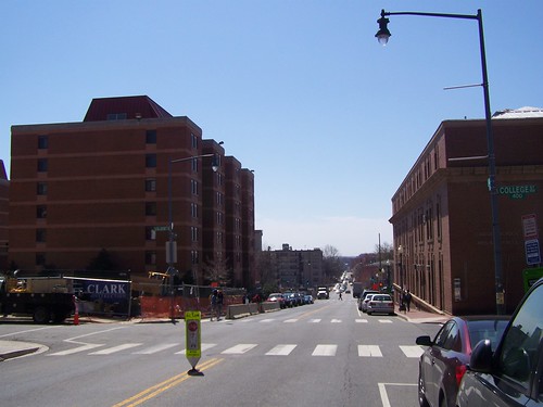
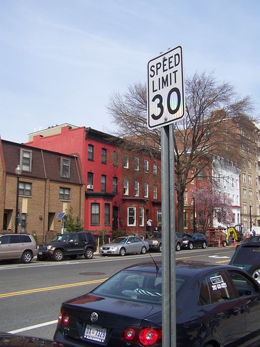 In noticed this awhile back on Pennsylvania Avenue in Capitol Hill, and I noticed it yesterday on 11th Street NW (see photo, right; you can't tell but the sign is really small too, it's about half the size of a normal speed limit sign).
On upper portions of arterials such as Georgia Avenue or Connecticut Avenue, I think the speed limit has been set at 30 mph for awhile.
Ideally, the WeMove DC Transportation Planning effort would turn back that decision, by laying out pro-people transportation policies and practices.
I am a fan of the Smart Transportation Guidebook, produced by the Delaware Valley Regional Planning Council, for both NJ and PA, and adopted by the State of Pennsylvania, because it does four things:
1. It defines roads in terms of land use context
2. It defines roads in terms of whether they are "community" serving or "regional" serving (although sometimes roads are both, which is the issue in DC)
3. Land use context is used to define appropriate roadway and roadside characteristics.
4. Land use context is used to define appropriate levels for the "desired operating speed" for traffic.
----------------
P. 23 from STG
Desired Operating Speed: This is the speed at which it is intended that vehicles travel. The roadway context should play a large role in determining the desired operating speed. For example, pedestrian travel and the presence of civic uses and retail close to the street all suggest the need to use the lower range of the desired operating speed.
Roadway: The design team should select roadway elements and geometry with a clear understanding of surrounding land uses. For example, in urban areas the design team should always seek to provide parking lanes. Travel lanes are often narrower than in suburban areas, particularly if this enables the installation of bike lanes.
Roadside: The roadside primarily serves the pedestrian and the transit rider and provides a transition between public and private space. The design of the roadside elements should support the land use context. Civic uses such as schools and parks, and high density neighborhoods which generate higher pedestrian activity may require wider sidewalks.
______________
The basic point is that urban land use is typically comprised of mixed use communities like typical neighborhoods in DC, which mix commercial districts, residential districts, and civic assets like schools, parks, libraries, and recreation centers.
In such situations people walk, bike, and use transit a lot more than they may drive.
Plus, rather than concede primacy to the car, the Smart Transportation Guidebook aims to balance the transportation network's competing goals of serving regional traffic (people traveling to and from the city), throughput (ability of the traffic to move unimpeded), and local traffic (people moving in and around their community).
What that means in a city is that posted operating speeds are typically less than that of suburban jurisdictions.
But what has distinguished DC from most major U.S. cities is that the prevailing speed limit is 25 mph, not just for residential serving roads, but for major arterial roads serving as both regional roads and community roads.
In most cities, including New York City, the prevailing speed is 30 mph. (Even though now NYC has a significant and expanding "Slow Zone" Program, which sets the speed limit for neighborhood serving streets at 20 mph.)
For a city that touts its commitment to sustainable transportation, raising the speed limit in residential places is very troubling.
Another good resource for these kinds of questions is a manual produced more than one decade ago for the State of Oregon. Main Street: When a Highway Runs Through It is designed to help communities and the Oregon DOT to come to resolution on these same kinds of issues, balancing the needs and desires for roads serving both intra-community and regional mobility demands.
It's very interesting that Oregon law sets basic speed limits according to land use context, and while they allow 30 mph in mixed use districts, they set that as the maximum speed, acknowledging the appropriateness of lower speed limits.
SPEED ZONES (page 24)
State statutes specify the following designated
speeds (1997 ORS 811.105):
• alleys ...................................... 15 mph
• business districts, school zones when
children are present................. 20 mph
• residential districts, public parks,
ocean shores ........................... 25 mph
• rural highways, urban interstate
highways, trucks on rural
interstate highways .................. 55 mph
• autos on rural interstates ......... 65 mph
.... "At the posted speed of 30 mph, many drivers have a difficult time seeing bicyclists and pedestrians, and stopping distance is nearly twice that of 20 mph."
Re-engineering roads according to land use context
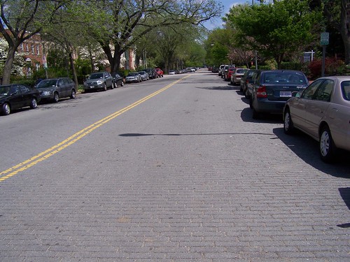 A couple times a year probably, I suggest that we should re-engineer road pavement type so that it is better aligned with land use context.
I make this suggestion because otherwise, roads are designed to enable very fast driving and cars (except maybe the SmartCar) are for the most part engineered to be driven very fast. Neither works well for residential areas.
For example, the street pictured on the left is South Carolina Avenue SE in Capitol Hill. It's comprised of asphalt block, and the pavement provides visual, physical, and aural cues to slow down.
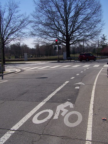 When I was on jury duty, I was cycling regularly on a beautiful way to Downtown (for most of the way), along 5th Street NW south of New Hampshire Avenue (the road becomes Park Place NW and then 4th Street).
Right: bike lane on 5th Street NW, approaching the northern edge of the Armed Forces Retirement Home.
At the eastern edge of the Howard University campus, 4th Street is fronted by many dormitories (the City Paper wrote recently about how two of the former parking lots on this street are being remade as dormitories, see "Howard Will Build Two Big Dorms on 4th Street NW").
Not only should the city work with Howard University to take off at least one lane of parking so that a bike lane or cycletrack can be continued here, but the road should be re-engineered to better serve its context as a pedestrian zone-street serving Howard University students.
Like setting pedestrian-appropriate speed limits on the city's streets, the city should begin to re-engineer streets to better achieve the city's purported urban design, placemaking and sustainability objectives.
4th Street NW, south of Howard Place NW
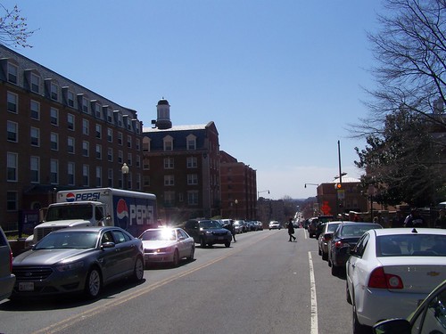
The new dorms are being constructed in sites pictured at the top left and bottom left of this photo.
Labels: neighborhood-based transportation planning, traffic engineering, transportation planning, urban design/placemaking
posted by Richard Layman @ 10:51 AM&Permanent Link
![]()
![]()


8 Comments:
I suspect what woud work better for everyone is moving towards 25 MPH and removing stop signs.
removing stop signs? and that makes the roads safer for pedestrians how?
I think the comment above was basic sarcasm about the speed limit elevation. In regards to the article- I can personally site a real life example. On Eastern Avenue, NE. in the Deanwood area (20019),there have been numerous vehicle related accidents that have affected my neighbors as well as myself-in regards to vehicle damages. A former neighbor of mine had petitioned a traffic study-which was granted. There were findings of excessive speeding on the street. The most that was done to "Resolve" or "remediate" the issue, was to install rumble strips on the street- which lasted a week. Afterwards, things went back to normal regarding the speedway known as Eastern Avenue, Sheriff Road, Division Avenue. Apparently, this was the only viable solution to the problem that they DC Government (I cannot remember the name of the agency)could provide because although the street was purely residential-with only a small remnant of commercial establishments, it was considered a "Major Thoroughfare". However, years later DC decided to install speed cameras on a "Major Thoroughfare" known as I-295 ( Kenilworth Avenue). So what I don't understand is why it is okay to put a speed camera on a freeway ( which is a major thoroughfare), but not on a residential street (that was declared or considered a "Major Thoroughfare")? It cannot be both ways- this street should not be denied a speed camera becuase of its "classification", yet a speed camera be allowed on a frreeway-where traffic is expected to be at a constant, accelerated traffic flow. It only boils down to this-MONEY. If it were about safety then the same type of speed cameras installed on 295 would've been installed on a residential street and not BS Rumble Strips. But because there is a probability of receiving more revenue in putting a speed camera in a place where traffic is expected to flow at speeds of 50-65mp. ( which is also a location in which few accidents occured), the cameras were put there instead of a location where there has been proof of re-occuring accidents and where people could get injured or worse, oh and let's not forget that if a camera were to have been placed on this street it would been in the most obvious spot at a location not even remotely near the problem area(resulting in a waste in a waste of resources-of an officer and a squad car being stationed in the obvious location where everyone would slow down long enough until out of range and taxpayers' money-in not resolving the issue, but allowing this activity to take place without any real solutions to the problem.So, NO-its more about the money and less about safety and now some dimwit is suggesting that the speed limit be raised? Only in DC-where greed runs ammuck.
I apologize for writing a book. Just had to vent. Thanks for listening. Oh, and I'm W7Cto20877 btw. I could not post it under this name
DK that part of Eastern Ave. (I will try to get over there.) Speed depends in large part on the width of the street and the amount of traffic. Low traffic, wide street = high rate of speed. Not a good combo for neighborhood-serving streets.
Not sarcasm at all
http://www.spiegel.de/international/spiegel/controlled-chaos-european-cities-do-away-with-traffic-signs-a-448747.html
(and in general, Europeans are horrified by the number of stop signs in the US)
I'd agree DC might not be the best place for this experiment -- between entitled drivers and Maryland drivers you've got a lot of problems -- but it is worth considering.
Watching bike flow is very useful in this -- you can see some streets where bikes just blow through stops, and those are good candidates for removing the signs.
woonerfs scare the hell out of me, kinda like people saying to a planner "why can't we be like portland?"
in either case it's about transition and initial steps because of vision and constant incremental improvement.
to jump from where we are today to woonerfs tomorrow would terrify me.
similarly, "portland" started with a decision to tear down the waterfront freeway in 1970, and a visionary downtown plan in 1972 that prioritized transit. LR came later and streetcars came later and biking and pedestrian promotion came later still...
Speaking of "why can't we be like Portland?"...
http://www.wweek.com/portland/article-19687-block_busters.html
Perhaps the more pertinent question should be, as the capital city of the US, why are we looking to the provinces for solutions rather than setting the standards?
-EE
Thanks for this post.
This post shares information about dc neighborhood.
Visit here to buy online medicines-"drugstore online".
Post a Comment
<< Home