Complete Places are more than Complete Streets
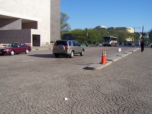
Stone paver street between the East and West buildings of the National Gallery of Art.
A press release from DC's Department of Transportation went out, stating that the agency has adopted a Complete Streets policy. Typically, a complete streets policy means that the transportation agency plans for comfortable movement for all modes within the street network. Basically, it means that walking, biking, and public transit are to be accommodated in complementary and equal fashion to how planning typically emphasizes motor vehicle traffic.
While I haven't come up with a better term, sometimes I say "Complete Places," and the Project for Public Spaces has a training workshop on "Streets as Places," there is more than a "complete street" to a complete place.
It has to do with how other government agencies prioritize funding and where they choose to invest scarce public resources, and how capital improvement programs work and whether or not the various agencies coordinate their efforts.
For example, the District of Columbia Government:
1. Doesn't coordinate capital improvement programs according to what we might consider Complete Places practices. E.g., the Gazette has an article about a combined library and recreation center coming to Wheaton ("Officials present plan for combined library and recreation center"), and Montgomery County and Arlington County have a number of such projects, including the Rockville Town Center, which includes a public library, other county facilities, and the VisArts nonprofit visual arts center.
How Arlington County redid the Shirlington Library to include the Signature Theater, which in turn became a key cultural asset for the Shirlington commercial district and extended the viability of the commercial district by increasing the number of visits and ancillary spending, is an example of how to coordinate capital improvements with a complete places program. (See "Savoring the Sunbeams in Shirlington" from the Post.)

Shirlington Library and Signature Theater.
Another example is how the DC Dept. of Housing and Community Development sold a piece of land for a hotel at Michigan Avenue and Irving Street NE, when instead investment in that area should be focused on revitalizing and improving the Brookland commercial district--now on 12th Street NE mostly, but also extending and recentering on Monroe Street and around the subway station.
Another example would be the plans for Walter Reed redevelopment. I know that there is a lot of land and people want to develop it, but by creating yet another area of retail development along Georgia Avenue in addition to the other nine marginal commercial districts along Georgia Avenue (around Howard University, around Park Road, at the Petworth Metro Station, at Upshur, at Kennedy Street, at Missouri Avenue, at Piney Branch Road, north of Walter Reed, at the City-County line) doesn't improve the extant commercial areas. According to the Post article, "D.C. to unveil plans for redevelopment of Walter Reed," 200,000 s.f. of retail will be built on Georgia Avenue on the Walter Reed campus -- in addition to the more than 1,000,000 s.f. that already exists and is mostly marginal.
2. How about an overall complete places policy and initiative? We need a Complete Places/Placemaking Initiative for the entire city, not unlike Placemaking Chicago.
Dan Malouff wrote a really really great piece in Greater Greater Washington last week, "Let's convert Scott Circle into Scott Square," opining about how Scott Circle could be reclaimed and rebuilt into a square, with a much greater sense of place. This extends ideas expressed in the improvement of Thomas Circle by DDOT a few years ago, and how Logan Circle regained its original footprint in the 1970s, after losing parkland to more roadways.
Thomas Circle improvements are shown in the entries on Truxton Circle.
Relatedly, the Tommy Wells blog mentions that DDOT plans to plop some more traffic calming measures around Lincoln Park. See "Details on New Raised Crosswalks at Lincoln Park."
And, there is an initiative to make Connecticut Avenue safer for cars. See "What would make Connecticut Avenue safer for pedestrians" from Greater Greater Washington.
And a couple years back, someone proposed bringing back Truxton Circle in the Bloomingdale neighborhood. See "Before and after: Truxton Circle" and "What a "Complete Places" land use and transportation planning philosophy would mean in practice."
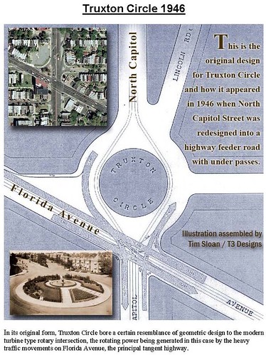
Image by Tim Sloan.
Probably the best thing that could be done to traffic calm the area around Lincoln Park would be to replace all of the pavement with asphalt block. This is comparable to how parts of South Carolina Ave. are paved, Monument Avenue in Richmond, or how more expensive granite pavers are used on 4th Street between the east and west wings of the National Gallery of Art, and in public squares in many European cities.
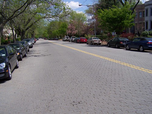
900 block, South Carolina Avenue SE.
I know it's expensive. But I think, at this time anyway, it's about as close as we can get to woonerfs in the U.S.
The visual, aural, and physical cues would slow motor vehicles down.
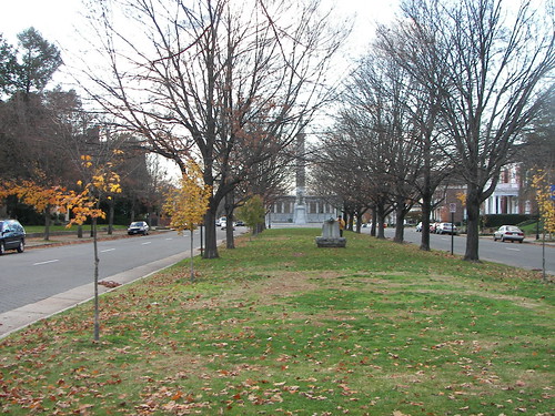
The median strip (boulevard) on Monument Avenue, Richmond.
While I have thought this should be done around parks for a long time, discussions over the years with community advocate Andrew Aurbach led me to believe this should be done around all park squares/circles (including Stanton Park), schools and other civic buildings used by the public (libraries), and commercial districts.
Andrew was on the HPRB for a term, and is one of the leaders of the Connecticut Ave. pedestrian initiative.
3. Somehow, a "Complete Streets" and a "Complete Places" policy has to address the centrality of parking as driving neighborhood planning. People's focus on parking makes it really difficult to improve neighborhoods. The ironic thing is that the focus on parking for cars means that people neglect to focus on placemaking and livability overall.
Charging higher prices for parking, and as Christopher suggests in a comment to a previous entry, directing that money to transit and other public realm improvements is the way to go.
4. The way to think about this is in terms of what David Barth of AECOM calls an integrated public realm, in the presentation Leadership and the Role of Parks and Recreation in the New Economy. That's the kind of citywide initiative we need!
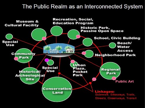
The red buildings in this image depict commercial districts. David Barth images.
------------------------------------------------------------------------------
From the DDOT press release:
Complete Streets Policy
I. Policy
a. The District’s transportation network as a whole shall accommodate the safety and convenience of all users, recognizing that certain individual corridors have modal priorities. While these priorities should remain and be encouraged along specific corridors, connectivity throughout the network for users of all modes is essential. Examples of modal priorities include, but are not limited to, residential streets, green streets, school routes, and corridors that are important to transit, freight, commuter traffic, and retail;
b. All transportation projects shall reflect the land-use, transportation, and green space needs of the city-wide transportation network, be sensitive to its various contexts, and should improve, not diminish, network connectivity;
c. All transportation and other public space projects shall accommodate and balance the choice, safety, and convenience of all users of the transportation system including pedestrians, users with disabilities, bicyclists, transit users, motorized vehicles and freight carriers, and users with unique situations that limit their ability to use specific motorized or non-motorized modes to ensure that all users can travel safely, conveniently and efficiently within the right of way;
d. Pedestrian, bike, and transit Level of Service (LOS), in addition to vehicle measurements, shall be evaluated to ensure proposed alternatives balance, as appropriate, the needs of all users of the right of way.
i. The planner or designer shall calculate and design for an appropriate combination of LOS that accommodates all users;
ii. The planner and designer shall also refer to previously established plans to ensure consistency;
e. Wherever possible, projects should help DDOT achieve goals as set by the Action Agenda or subsequent strategic plan;
f. Improvements to the right of way shall consider environmental enhancements including, but not limited to: reducing right-of-way storm water run-off, improving water quality, prioritizing and allocating sustainable tree space and planting areas (both surface and subsurface), reusing materials and/or using recycled materials, and promoting energy conservation and efficiency wherever possible;
II. Procedures
a. The aforementioned policies shall be employed in all transportation planning, design, review, operations, major maintenance projects (such as milling and overlay), new construction and reconstruction projects, except where prohibited by federal and District law (such as interstates, non-motorized trails);
b. Routine daily maintenance and operation activities (such as potholes and cracked ceilings) are specifically exempt from this Policy. Any other exceptions require written justification, documentation, and approval by the DDOT Director or Delegate. Exceptions may be granted based upon documented safety issues, excessive cost, or absence of need.
Labels: bicycling, car culture and automobility, transit, transportation planning, urban design/placemaking, walking
posted by Richard Layman @ 4:18 PM&Permanent Link
![]()
![]()


0 Comments:
Post a Comment
<< Home