The DC Transit Network
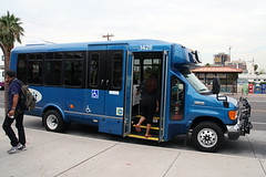
Venus Lee/The Arizona Republic. Hundreds of people have signed petitions, sent e-mails and made phone calls voicing opinions about if and where free shuttle service should be expanded throughout the northern half of Tempe.
In my People's Transportation Plan (in part based on a paper I wrote last May) I suggested the creation of an intra-neighborhood transit network* that could be free, and oriented to getting people to and from within a neighborhood, to transit lines and stations without having to drive, and including delivery of goods and services from local commercial districts. And I suggested this could be a free service
It turns out that Tempe Arizona has refigured part of its bus service to do exactly that.
See the Tempe In Motion (the city's Department of Transportation) website for information on the Orbit bus system as well as these articlea from the Arizona Gazette, "Neighborhood circulator buses bring sense of community" and "Venus, Mercury bus routes are in Tempe's Orbit circulation." (Note that the commenters for the later article weren't supportive.)
From the Orbit webpage:
Orbit (a FREE service) uses mini-buses to serve residential areas and connect them to local destinations such as shopping areas, other neighborhoods, major bus routes, schools and multi-generational centers. All Orbit routes run from 6 a.m. to 10 p.m. every 15 minutes, 7 days a week. "No stop zones" occur in between the crosswalks of all schools served by an Orbit route. The Orbit routes use “flag” stops, which means that the driver will pick up and drop off passengers in residential neighborhoods provided it is safe to do so.
Note that the Tempe In Motion website is another example of a best practice government agency transportation website, focused on mobility, not just transit.
-------
* The transit network
Regional Transit Network: Regional WMATA subway system; MARC and VRE railroad service; ferry system if added; cross-jurisdictional bus rapid transit; commuter services oriented to moving people between the jurisdiction and major job centers within the region, across jurisdictional boundaries (i.e., OmniRide from Prince William County, which provides commuter-oriented service to Metro stations and job centers, with an end point in DC [and back] or the MTA Commuter buses).
Suburban Transit Network: transit systems (bus primarily at this time) operated by Counties and Cities providing intra-community service for the most part, with occasional cross border service.
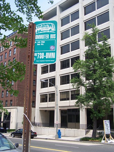
Omni Commuter Bus Sign, E and North Capitol Streets NW, Washington, DC.
DC Primary Transit Network: Core of the WMATA system in DC (29 stations); streetcar system; Downtown Circulator bus service; Georgetown Connector shuttle service; cross-border WMATA bus service; bus rapid/rapider transit.
DC Secondary Transit Network: the other 11 subway stations in the city; other WMATA bus service within the city; water taxi service if added, depending on the routes.
DC Tertiary Transit Network: intra-neighborhood bus services. Maybe private shuttle services (i.e., Washington Hospital Center to/from Brookland Metro, university shuttle services, etc.).

The subway stations at the core of the city of Washington comprise the foundation of the DC Primary Transit Network.
Note that if the two new subway lines were added in the city, as proposed on the map below, then this would change the definition of the core of the DC Primary Transit Network considerably.

Conceptual map for transit expansion in the DC. Map courtesy of David Alpert, Greater Greater Washington.
--------------
Note: this is predicated on having a large base of transit users, and a high-capacity transit network to move people around, to destinations that people want to visit, and visit regularly (like the workplace). Buses running around neighborhoods day and night with few users wouldn't work. E.g., in Ward 5, people with Ward 5 parking stickers can park close to the Brookland Metro station using the same residential parking permit. Around Metro stations, parking permit privileges should be defined more narrowly, to encourage people to take the intra-neighborhood bus to the station. Etc.
--------------
Labels: transit, transportation planning
posted by Richard Layman @ 8:38 AM&Permanent Link
![]()
![]()


6 Comments:
That's a great article! The neatly organized content is good to see. 스포츠토토
Thanks for sharing such great knowledge with us. Looking for some more information from your blog. 온라인카지노
Hi there, you have done an excellent job. I will certainly dig it and personally suggest to my friends. 토토
Amazed to be here and want to read this amazing info.
스포츠토토링크는
Thanks for Nice and Informative Post.
카지노사이트
This article is really contains lot more information about This Topic.
온라인카지노
Post a Comment
<< Home