It's time for a new "city beautiful" movement in DC
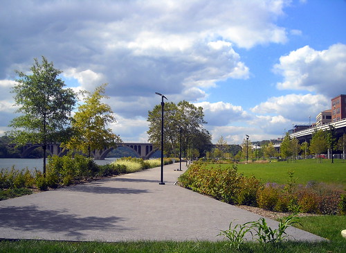
Flickr photo by NCinDC of the Georgetown Waterfront Park, which in its most recent previous incarnation was parking lots.
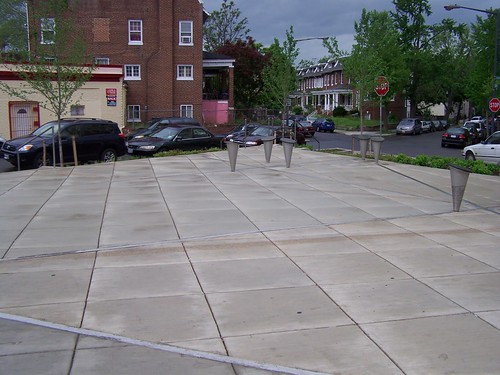
Pocket "park" on 14th Street NW in Columbia Heights
Despite the fact that livability issues (dog parks, community gardens, bike paths) were made out to be a whitey plot in the last election, there are many livability ideas and projects percolating in various places in the city, ranging from city initiatives like the "Yards Park" on the Southeast waterfront, the Georgetown Waterfront Park, or a number of really lousy terribly done pocket park initiatives such as the re-doing of the pocket park on 14th Street NW at Oak Street in Columbia Heights to a variety of ground up citizen-generated ideas.
In the late 1990s, when DC's Department of Transportation initiated the first streetscape redesign programs for Georgetown and Barracks Row (8th Street SE) and for Thomas Circle, to take back travel lanes that had been cut through the circle and to restore the park, and in the early 2000s, with initial planning for streetcars, and the creation of a public realm framework in Columbia Heights and for the Anacostia Waterfront, DC was on the cutting edge of placemaking planning for large cities.
Even though DC has a Public Realm Design Manual (another place where an earlier kind of version was produced as an appendix to the Brookland Streetscape and Transportation Plan, on pages 140-153), it's not clear that the process for considering streetscape improvement initiatives is very bold.
Now it's more of a tool kit process about curbs, bulbouts, and streetlights, but not so much about improving places in paradigm busting ways. And it's complicated by the fact that while the placemaking movement has continued to advance, DC's streetscape and placemaking planning initiatives have not moved forward at the same pace. For example, it's taking DC 10 years to get its first streetcar line, while it took Seattle 5 years.
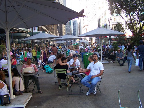
In NYC, the way that spaces formerly given over to the car are being remade over for pedestrians and bicyclists is a national story. See "City Has Transformed Broadway" from the New York Times.
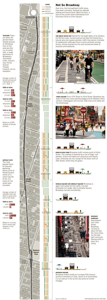
New York Times graphic on Broadway's changes.
Similarly, San Francisco has a wide-ranging livable streets program, which has brought into one program a variety of efforts which in other cities (except maybe for New York City) are typically spread across different agencies or different departments within a single agency but the programs aren't coordinated.
The SF program starts off with a BHAG--a big, hairy audacious goal--making San Francisco not only the best city for walking in the US, but in the world--and incorporates pedestrian programs, streetscape improvements, traffic calming, bicycle planning, and safe routes to school planning into one overarching program.
-- San Francisco Sustainable Mobility and Climate Action Strategy
In DC, while these programs exist, they are not internally integrated and while the Department of Transportation has a new livability planning initiative, thus far we see missed opportunities for coordinated improvements--although the livability planning paradigm offers us a lot of hope. From the DDOT Rock Creek West II Livability Study Final Report:
Livability is a term that refers to community quality of life as experienced by the people who live, work, and recreate there. Livability recognizes that strong communities rely on the interplay among transportation, public health, housing, cultural resources, and the natural environment.
Transportation, in particular, is central to livability. Travel choices govern our ability to get around; the operations of our transportation facilities impact safety and comfort; and the designs of our public spaces directly affect the prosperity and enjoyment of the city.
DDOT’s Livability program includes transportation studies for various neighborhoods of the District. The studies take a “big picture” look at the street network and identify concrete actions that adhere to the principles outlined in the DDOT Action Agenda. The goals of this study are to:
• Ensure safe passages for all users of the street network. This involves special attention to the most vulnerable users of the system (pedestrians, bicyclists, children, and the elderly); and taming traffic while maintaining overall mobility.
• Prioritize sustainable living in DC communities. This means providing a robust set of transportation choices and designing streets to encourage physical activity. It also means designing streets in ways that help preserve, protect, and/or restore ecological systems.
• Foster prosperous places by building and operating streets as unique urban places that support retail and employment districts. Enhancing prosperous places also may entail the expansion of civic open spaces within or along streets.
. But as far as improvements are concerned, thinking outside of the box is nowhere to be seen.
Somehow these ideas need to be truly embraced as the primary planning paradigm for the city, and integrate this approach systematically into the planning processes for the Office of Planning, the Department of Small and Local Business Development, and the Department of Parks and Recreation, and schools planning (public and charter schools), not just for the Department of Transportation.
These efforts are made more difficult by not having a master transportation plan or a Parks Master Plan.
And the issue is made more complicated by the fact that the city is not fully in control of the street and parks resources in the city--some of which are controlled by the federal government, and in particular, the National Park Service.
A couple weeks ago M.V. Jantzen wrote a series of posts in Greater Greater Washington about rethinking Dupont Circle which I think ought to be seen as a call to arms for re-thinking the city's park and placemaking agenda--for having one...
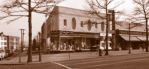
Image: Wymer Collection, Historical Society of Washington, D.C. This photograph from the 1940s show the original sidewalk, about 20 years before it was destroyed. Above: The corner of Connecticut and Ordway, currently home to Dino Restaurant, Suntrust Bank, and Brookville Market.
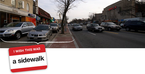
Similarly, in Cleveland Park, Herb Caudill and others are calling for re-widening the sidewalk "plaza" on the 3300 block of Connecticut Avenue, by removing the service drive and parking lane, and restoring the wide plaza.
They have a petition campaign running on their website, I wish this was a sidewalk and just had a long post in Greater Greater Washington, "Restore the sidewalk in Cleveland Park," explaining the various options that they see for restoring the wide sidewalk there on the in Cleveland Park.
There are other posts out there about restoring Truxton Circle ("Before and after: Truxton Circle)" and and creating "Scott Square," or pedestrianizing streets (for certain reasons I tend to not favor this, but that's an argument for another day).
I wrote about these issues on New Years Day, in a couple entries:
-- New Years post #3: How about more community self-help (Peter Riehle and Eastern Market Metro Plaza)
-- New years post #5: DC City Council Committees and striving to be a world class city (frankly, this post is so good, I'll reprint it tomorrow...)
and here, "What a "Complete Places" land use and transportation planning philosophy would mean in practice" and "Complete Places are more than Complete Streets."
Making every block of the city great, in terms of how DDOT terms the livability agenda as creating and maintaining safe, sustainable and prosperous places, is probably the best unifying agenda the city could create.
Labels: change-innovation-transformation, civic engagement, sustainable land use and resource planning, transportation planning, urban design/placemaking, world class cities
posted by Richard Layman @ 12:55 PM&Permanent Link
![]()
![]()


0 Comments:
Post a Comment
<< Home