Flashy one-offs vs. a program: the proposal for an 11th Street bridge linear park and the rest of the city
From Washington Present and Future: A General Summary of the Comprehensive Plan for the National Capital and its Environs (National Capital Park and Planning Commission, 1950):
Washington is a beautiful city because of its Mall, its parks, and the river. Yet in spite of these, the bulk of the inner residential areas are quite ordinary and certainly not beautiful. One redeeming feature of these sections is that street trees hide the ugliness. Beauty that exists must be preserved and enhanced. In the course of the improvement program laid out by the comprehensive plan, new beauty should be created.
-- Chapter: "Setting for Democracy; section: Civic Art; p. 41.
--------------------------------
The Bilbao Effect and civic undertakings elsewhere. Earlier in the week I wrote about Bilbao and the misperception that Bilbao doesn't have a revitalization program but has relied on a flashy building, the Guggenheim Museum Bilbao, designed by Frank Gehry as a kind of metallic public sculpture and work of art, to attract attention and revive the city.

While it is true that the GMB has been a significant element of the city's program of rebranding, repositioning, and revitalization, the reality is it is only one of more than two dozen major actions, totaling billions of dollars of investment, that Bilbao and the provincial, regional, national and EU governments have undertaken there, starting in the mid-1980s.
But that hasn't stopped other cities across the globe from trying to apply what they think is the "Bilbao Effect" by constructing a flashy cultural building of their own. Mostly they fail, because the Bilbao Effect is a program, not a one-off project.

New York City's High Line as another flashy project that other cities aim to copy.
Our next door neighbors have a five-year-old child who has a bunch of younger cousins--Marina constantly complains that her cousins "keep copying me" while not acknowledging that she in turn copies her older cousin and her schoolmates.

Success has been dependent on the fact that the infrastructure is well located and can be integrated into the existing street fabric in an area of the city that possesses a great many real estate development opportunities, in a strong real estate market, in a city where it is possible to raise a great deal of money philanthropically, paired with an implementing organization and ongoing program of activities.
In short the High Line's success derives from multiple elements:
- industrial infrastructure
- that is well located and placed and adjacent to population and therefore capable of being well-used
- and already somewhat integrated into the urban fabric
- with a program for repurposing
- the potential for funding
- the ability to generate spillover development
- plus being located in a hyper-strong real estate market.

People approach the High Line story simply--repurposing a piece of industrial infrastructure--and the circumscribed understanding of the "High Line Effect" may be just as dangerous as lack of knowledge about what the "Bilbao Effect" really is also.
It also is criticized as an element of touristification ("Disney World on the Hudson," New York Times). From the op-ed:
The High Line has become a tourist-clogged catwalk and a catalyst for some of the most rapid gentrification in the city’s history. My skepticism took root during my first visit. The designers had scrubbed the graffiti and tamed the wildflowers. Guards admonished me when my foot moved too close to a weed. Was this a park or a museum?Note also that area residents did not vote in favor of creating a special services and tax district to help fund park operations ("High Line Park Stewards Hoping for Neighborhood Tax," New York Magazine; "High Line plan is too taxing, neighbors cry" The Villager; "High Line Backs Down," Architect's Newspaper).
In 2011, the park had 3.7 million visitors and according to surveys and extrapolation, half the visitors were New Yorkers and the other half tourists.

Similar projects being pursued around the country include the Beltline in Atlanta, the 606 in Chicago, the Trestle in St. Louis, the Rail Line Park in Philadelphia, the Cumberland Valley Railroad Bridge in the Harrisburg, PA area, a project in Evanston, IL ("Evanston's own High Line Park -- for $19.5 million," Evanston Now) and undoubtedly others--frankly rails to trails projects have been the precursor to such projects and have been underway for decades.
There's an underground park project in NYC called the Low Line ("Considering an Underground Park in New York," Wall Street Journal), while there has been talk of a similar kind of project at Dupont Circle in DC for years.
DC's 11th Street Bridge Linear Park proposal. I am into bold projects like the High Line that involve the repurposing of transportation infrastructure and the creation of linear (and other types of) parks and trails, etc.

According to the latest Washington Post article on the concept, "D.C.communities split by the Anacostia could become closer in plan for first elevated park," now it's being pursued as a private initiative looking to raise $35 million to pull it off.
Of course, usually such bridge recovery projects--mostly repurposed into pedestrian bridges such as in Chattanooga (the 1891 Walnut Street Bridge was preserved as a half-mile-long pedestrian bridge) and across the Hudson River (the Walkway Over the Hudson, the former Poughkeepsie-Highland Railroad Bridge was transformed into a 1.28-mile-long state park) don't require that you tear down the bridge platform and rebuild it so it's safe--that's a kind of spurious cost that almost makes the 11st Street bridge park proposal a project not worth pursuing.
Plus, while the sentiments behind the project are particularly appealing in terms of equity and political correctness--let's connect "East of the River" (it's really south of the Anacostia, but...) with the Rest of the (Richer) City--the problem is that unlike the High Line, one end of the bridge, in Capitol Hill, isn't located within residential districts, and the other end, in Anacostia, is somewhat disconnected from residential precincts as well.
So the project could be great, or it could prove all of the points made by Jacobs in Death and Life of Great American Cities about how parks can be dead spaces, because of how they may be situated away from population and/or activity centers, and as kind of a variation of why "pedestrian malls" tend to not work except in very specific situations (see "Now I know why Boulder's Pearl Street Mall is the exception that proves the rule about the failures of pedestrian malls"), they fail.

Why isn't there more focus on improving our existing places? But these reasons, as important as they are, aren't even what bugs me about the proposal.
I understand that people are into flashy. But why not focus equally on urban design projects that may either be more easily realized and/or have significant places that already exist?
It's low hanging fruit, albeit the projects may still bel expensive, but not always, such as parklets.
The failure to address the many neglected opportunities across the city to reknit the scars created by a pro-automobile public space policy and/or improve streetscapes and placemaking opportunities in exisiting places is aggravating. I have written about this a lot already, in pieces such as these:
-- Complete Places are more than Complete Streets
-- What a "Complete Places" land use and transportation planning philosophy would mean in practice
-- Public Squares and DC
-- It's time for a new "city beautiful" movement in DC
And more recently in
-- DC's bad urban design as it relates to new transportation infrastructure
-- The layering effect: how the building blocks of an integrated public realm set the stage for community building and Silver Spring, Maryland as an example

Certainly, the way that New York City has pedestrianized areas along Broadway and in Times Square is one example of an alternative approach.
Another are the various parklet programs now spreading across the country (but not in DC), which started as a guerrilla initiative by the Re:bar group in San Francisco and later was taken up as an officially sanctioned program by the San Francisco government, and has since been copied by other r cities across the US and Canada.
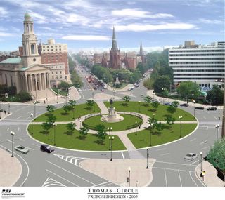 In 2005, DC's Department of Transportation restored Thomas Circle to its original configuration. In the 1950s, part of the park had been cut away in favor of more traffic lanes.
We have plenty of urban design opportunities across DC where we could make the streetscapes better and either create or re-create or improve neighborhood centers.
But we keep ignoring the chances we have or we are deliberately not choosing to do so.
Here are some places that could be significantly improved (of course there are many more):
- the re-creation of Truxton Circle at North Capitol Street and Florida Avenue NW
- decking over the North Capitol underpass--instead in a recent plan by OP and DDOT they punted the responsibility for initiating this to the neighborhoods
- decking over the Connecticut Avenue underpass at Dupont Circle
- restoring Dupont Circle to its original size by taking back the inner traffic lanes and making them park (this was done for Logan Circle in the 1970s and for Thomas Circle in 2006, note that Grant and Sherman Circles in Upper Northwest DC retain their original configurations)
- creation of a better Scott Circle (something that Dan Malouff at Beyond DC blog suggested a couple years ago)
- restoration of the original sidewalk configuration on the east side of Connecticut Ave. NW in Cleveland Park
- creating tunnels for through-commuter traffic for New York Avenue and parts of North Capitol Street and Blair Road (see "Tunnelized road projects for DC and the Carmel Tunnel, Haifa, Israel example")
- creating a circle at Georgia and Missouri Avenues NW
- creating the so-called "Brookland Green" as an element of repositioning Brookland around a new town center district centering on the Metro Station (see "Brookland neighbors ask Metro for development with a side of green" from GGW)
- creating a great park as part of the McMillan site redevelopment, instead of being happy with what's being proposed by the developer (see the commentary in this entry "McMillan plans show expansive new recreation spaces" from GGW--the entry is happy with what's being proposed while certain commentators, including me, think it could be a lot better).

11. Plus my point that pavement in commercial districts and around circles and squares and schools should be converted to Belgian Block to better reflect the pedestrianized nature of these places (see "It's all relative: conditions shaping road speeds and safe, comfortable places").
DC is good at one-off projects and bad at developing bold and systematic approaches to neighborhood public realm improvements. I am ecstatic with the incredible new parks and places that have been created in the city over the past 8 years or so, in particular the reconstruction of Thomas Circle, the creation of the Columbia Heights Pedestrian Plaza, the Georgetown Waterfront Park, the Yards and Canal Parks in the Capitol Riverfront District, along with various streetscape improvement projects on avenues and in commercial districts.
But for the most part these are one-off events that haven't been harvested as learning that feeds into a more comprehensive program. There isn't a systematic program for improving the urban design quality of the city and its neighborhoods--unlike in cities like New York City and San Francisco, even though arguably, DC started to implement similar improvements much earlier.
Resources from the Project for Public Spaces

North Capitol Street Corridor in Mid City. As an example, the DC Department of Transportation has produced a Livability Study, focused on public realm and transportation improvements for what they call Mid City East, covering an area of the city that lies between Rhode Island Avenue on the north and New York and Florida Avenues on the south.
According to the study webpage:
Collaboration with local residents, community leaders, and agency partners, focused the study on four primary objectives:The plan has some decent discussion on the roadway network and system and desired characteristics (frankly, this discussion would have been better had it referenced the transportation network and land use context framework developed within the Smart Transportation Guidebook used by New Jersey and Pennsylvania--one of my complaints about the current DC master transportation planning process is the failure to start with robust frameworks to guide development of each of the elements, and this includes how the roadway network and system is conceptualized in terms of local land use contexts and whether or not roadways are primarily community or regionally serving or mixed).
- Link the communities across the major arterials.
- Reconnect the communities to the larger city.
- Reclaim minor streets and corridors from commuters and restore them to community needs and character.
- Increase resiliency to flooding and other climactic effects.
The most significant factor degrading quality of life in the Mid City East neighborhoods is the way that the major arterials act as major gateways in and out of the city and enable automobile traffic to dominate and disconnect the neighborhood at the expense of quality of life. This is acknowledged by the goals of the plan.
See the arguments about the impact of this kind of problem in Livable Streets by Appleyard and Reclaiming our Cities and Towns: Better Living through Less Traffic and Street Reclaiming: Creating Livable Streets and Vibrant Communities by Engwicht.
While this was discussed in the planning process, and recommendations for improvements were made for various intersections and certain corridors, for the most part, bold solutions, such as decking over North Capitol Street even when suggested by residents, were not considered and ended up being barely referenced in the final plan.
Of course, one of the boldest ways to address the problem would be to deck the North Capitol underpass, which would be significant, expensive, and I think a greater priority than building a bridge park across the Anacostia River. (Note that separately I have suggested that the commuter traffic on streets like North Capitol and New York Avenue should be diverted to tunnels. See "Tunnelized road projects for DC and the Carmel Tunnel, Haifa, Israel example." This was suggested for New York Avenue in a DDOT study in 2005.)
Similarly, restoring Truxton Circle as a way to restore neighborhood-serving qualities to the roadway network was not addressed in the recommendations either, although it was suggested that the old Truxton Circle fountain, still extant, could be installed in an area park.
According to this recounting of the process ("Plans seek to keep Mid City East affordable," GGW), the planners suggested responsibility for initiating such a program, despite its complexity, lies with the neighborhood. (Note that it is confusing because the plan was billed as a joint effort by DC Office of Planning and DDOT but the final document references DDOT only.)
While I believe that the various recommendations in the plan will contribute to neighborhood improvement upon implementation, the most fundamental urban design problems faced by the neighborhood for the most part remain unaddressed and it remains to be seen how the overall character and quality of place will significantly improve.
In 2000, DC's new streetscape improvement program and the plan to restore Thomas Circle were at the level of national best practice. Since then other cities have moved far beyond that level of practice, while DC hasn't moved its circa 2000 policies significantly forward.

San Francisco and New York City (see "San Francisco Sustainable Mobility Agenda") have transformed their approaches to public space and are re-prioritizing the role of streets and public space in terms of serving pedestrians, bicyclists, and transit users, which need to be the priority in those places--like DC--where walking, transit, and biking are the dominant modes.
Another example is Dallas' creation of a park over part of a center city freeway, which has just been written up in the Build a Better Burb blog. According to their entry:
Deck parks themselves aren’t new; the first green space to cap a freeway was Manhattan’s Carl Schurz Park, built in the late 1930s over the FDR Drive. Some twenty other parks now exist in places such as Phoenix, Duluth, MN, Seattle, and Boston, and proposals are now on the table in Los Angeles, Cincinnati, and St. Louis.In DC, freeway decking has or is occurring in high value locations. Part of I-395 has already been decked over for court buildings and a crappy park, as well as an apartment building on K Street NW, while separately, in an exciting project called Capitol Crossing, real estate developers will be decking over another section of I-395, in part restoring the street grid, and constructing buildings there. See "I-395 air rights now Capitol Crossing" from the Washington Business Journal. (I expect it will happen with the Southeast-Southwest Freeway, now numbered I-695, some time in the future also, because of the potential value of the recovered land.)
Expecting a neighborhood to initiate such a project like with North Capitol Street isn't realistic.

But for the most part, DC's streetscape and neighborhood urban design accomplishments haven't gone beyond the original conception of the program back in 2000.
Even though we are adding a bunch of great new spaces, we aren't adding enough of them, and many of the new spaces fail to realize all that would be possible, were more robust planning systems in place (as discussed in the above-cited entry that addresses layering, using Silver Spring, Maryland as an example).
Note that DC planners would disagree with my assessment of current practice, and likely would argue that the DDOT Public Realm Design Manual represents best practice and the city is focused on achieving pathbreaking projects.
I would argue that the manual is good for outlining streetscape improvements, but not so much for achieving significant improvements in terms of a more robust integrated public realm and civic assets framework.
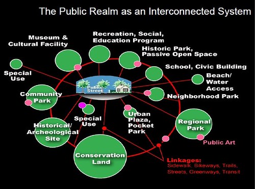
Conclusion. DC needs to adopt a more robust framework for improvements to and integration of the public realm, along the lines of what David Barth of AECOM calls an integrated public realm framework. That's the kind of citywide approach that we need. (Note also that this includes transit infrastructure. See "Transit, stations and placemaking: stations as entrypoints into neighborhoods.")

As long as the focus is on one-off projects and the flashy we will continue to limit the value we receive from the hundreds of millions of dollars that we spend every year on the city's transportation system and infrastructure.
Coordinated planning and a willingness to think big (note that thinking big doesn't always mean expensive, although it does in the case of roadway decking) would get us a lot more in the way of quality of life and placemaking improvements than we are achieving right now.
Labels: civic assets, neighborhood-based transportation planning, public realm framework, sustainable land use and resource planning, transit, transportation planning, urban design/placemaking
posted by Richard Layman @ 5:54 AM&Permanent Link
![]()
![]()


9 Comments:
"Transportation restored Thomas Circle to its original configuration. In the 1950s, part of the park had been cut away in favor of more traffic lanes."
Is this true? I have admired the Thomas Circle redo from the get-go, and had always heard from others that the whittling away of Thomas Cir was due to traffic lanes. However, last week on some other blog (?) I saw photos of the circle and the "football" shape of the pre-restoration circle was clearly formed by streetcar tracks that cut through the circle. Nothing against streetcars, but just trying to determine the facts.
I don't think the streetcar tracks were exclusive. But I could be wrong--but I doubt it.
This photo from 1943 does not indicate that the streetcar tracks used the expanded traffic lanes exclusively.
http://en.wikipedia.org/wiki/File:Thomas_circle_December_1943.JPG
I'd add Washington Circle to that list.
The current (NPS?) suggested ideas are turning into a real mess.
I'd also deck over the two small section of K st that are exposed on either side of the circle and turn that into a park area, or concession stand.
It wasn't meant to be a definitive list. This definitely is worth adding!
Yglesias has a similar comment, and I guess a broken clock is right twice a day.
Part of the problem is the consultant driven nature of planning these days. Lots of PR on shiny new things and zero focus on the core competency of what city governments actually do. You wan a bilbao? Millennium park? High line? Bikeshare?
meanwhile nobody can invent a paint that will let bike lanes last more than six months. Or light timing. Or better garbage pickup.
(for both Y and me...)
U R right about consultant and hype driven planning. It's also the Mayors and Council people in places too.
Cutting a ribbon is a lot more fun than the nitty gritty.
Mayor Gray is a perfect case in point with sustainability. He went to a conf., heard other mayors talking about what's happening in their cities, and then came back and said "we have to be the best at sustainability."
So we have a sustainability plan and goals, but most of the time, when practices are being implemented, they fall short of sustainability best practice or the general concept of sustainability.
e.g., my point about Dunbar or yours about Cardozo.
Although I would have put the money into Cardozo, not Dunbar, because the center city needs a high school, and the redistributed students from Dunbar would have helped the other schools.
Note we are running into the same coming problem with Roosevelt and Coolidge, both in Ward 4. There's not enough students really for both the schools. Nothing is happening right now to end the momentum to rehabilitate both.
That's why I keep suggesting moving Ellington to one of the schools. That would allow the reopening of Western to serve Upper Northwest, as Wilson is overcapacity.
It would make the "City" "Arts" school Metrorail accessible, which is a plus.
And it would allow W4 to have one in boundary high school at full enrollment strength.
Now that's sustainability, and it would require making hard, bold choices.
I don't see it happening.
.... it's not a fully appropriate example, but one of the comments I make about Balt. County Govt. is that the elected officials only compare how they are doing to Baltimore City. That's a competition they'll always win on economic grounds, for the most part.
But it's not either a fair comparison or the right comparison, if they really want to be great (which is arguable too, maybe being better off than Baltimore City is enough). They need to benchmark against highly functioning counties in the region, not Baltimore City...
So with DC it's my counter application of Moynihan's "defining deviance down." As the national capital, we define whatever we do as "world class" even when it isn't. I call it "defining mediocrity up."
Thank you for providing such a valuable information and thanks for sharing this matter.
Nice Blog. Thanks for sharing with us. Such amazing information.
How Hand Emoji Can Make your Conversation Interesting
MyBlogger Club
Guest Posting Site
Best Guest Blogging Site
Guest Blogger
Guest Blogging Site
Great Writing Skills. Thank you for sharing.
Post a Comment
<< Home