Western Baltimore County Draft Pedestrian and Bicycle Access Plan
This is the project I worked on from September through June, creating a pedestrian and bicycle plan for about a 110 square mile area of the urban section of Baltimore County--the county is about 660 square miles, but 2/3 is designated rural, and the other 1/3 is designated urban--my section was half the urban area or 1/6 of the total county. 90% of the county's residents live in the urban designated area. And Baltimore County was one of the first localities in the United States--in 1967--to create an urban-rural growth boundary.
It was a great learning experience for me, because I had never worked directly for a government agency, and I got a good lesson about the process (and difficulties therein) about working on change from "the inside," about how to work to make your desired outcomes congruent with other agencies, about how there are very defined protocols and communications mores for speaking and communicating publicly as even a lowly representative of the Executive Branch.
The position was term limited, funding by regional (federal) transportation planning monies. Given the current budget situation, now wasn't the right time for the County to create a full time bicycle and pedestrian planning operation, whether or not they'd hire me to do so, so the job ended when the draft plan was "finished" -- or at least turned in on June 30th, per the requirements of the grant.
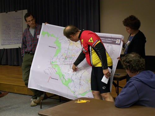
Almost 200 people attended one of four citizen workshops on the plan. Almost 300 people submitted surveys online on the website. There were some articles about the project in community newspapers, including this article from the Arbutus Times and the Catonsville Times, "Input sought on safer bicycle, walking paths in western county," in addition to stakeholder meetings, community presentations (one of which, to the Cromwell Valley Park Council, I got my block knocked off, and I was underprepared), emails, and phone calls. This photo is from the workshop in Catonsville. We broke down into small groups, and people filled out surveys, talked about their experiences walking and biking in the county, and using large maps, indicated areas where facilities improvements are needed.
Now, after the draft was submitted, some things (that I feel very strongly about) were taken out, but all in all I am reasonably happy with the "final" result, which was posted yesterday, and the draft plan is now in the public comment stage.
Because of the time constraints--two people working 80% time (me, and the GIS Analyst, Bineeta Sihota, who was great) and overseen by our boss (who probably ended up spending more time on the project than was anticipated)--I won't claim that it is the best pedestrian and bicycle plan produced in the U.S. in 2010. But it's still quite good, and proposes significant improvements and systems development for bringing about behavior change, particularly in the education and encouragement realms, far beyond what it is typical for a county to do or a bike and ped plan to propose (the earlier draft documents are more detailed).
I'd be interested in working there to attempt to bring the plan to fruition, but it would require significant lifestyle changes, probably a move to Baltimore, which would be a tough decision because we really like our house (although I am fed up with local politics and civic affairs in DC frankly)...
From the Western Baltimore County Pedestrian and Bicycle Access Plan website:
The technical advisory committee and the Office of Planning have developed a preliminary draft for public comment. The draft is also being circulated among county and state agencies for additional input on the plan.
The citizen input from the workshops helped create the implementation recommendations of the plan. Office of Planning staff compiled and analyzed the discussion notes and surveys from each of the workshops, along with the more than 270 surveys that were submitted online.
In the fall, a public meeting will be scheduled to receive additional public comment. A revised draft plan will be submitted to the Planning Board and ultimately to the Baltimore County Council for approval as an amendment to the County Master Plan.
View the full document (23 MB) (PDF)
View the plan in sections:
Table of Contents (1 MB) (PDF)
Introduction and Shared Use Paths (pp. 1-14) (3.5 MB) (PDF)
Walking 1 (pp. 15-26) (5.5 MB) (PDF)
Walking 2 (pp. 27-32) (4.5 MB) (PDF)
Bicycling 1 (pp. 33-41) (1.5 MB) (PDF)
Bicycling 2 (pp. 42-49) (5 MB) (PDF)
Bicycling 3 (pp. 50-58) (6 MB) (PDF)
Education, Encouragement, Enforcement, Evaluation and Appendices (pp. 59 to end) (2 MB) (PDF)
View full size color maps:
Proposed Pedestrian Improvements (5.5 MB) (PDF)
Proposed Shared Use Path and Bicycle Improvements (5.5 MB) (PDF)
In March, I did a presentation as part of the speaker series for the Montgomery County Office of Planning on what I consider to be best practices bike (and pedestrian) planning for suburban jurisdictions. That presentation outlined the approach I was trying to bring about in my Baltimore County effort.
See the blog entry "Best practice bicycle planning for suburban settings using the "action planning" method" for a discussion as well as a link to the Powerpoint presentation.
Labels: bicycling, car culture and automobility, change-innovation-transformation, transportation planning, walking
posted by Richard Layman @ 2:56 PM&Permanent Link
![]()
![]()


0 Comments:
Post a Comment
<< Home