Mapping retail trade areas for DC supermarkets
From the comment thread on the previous entry on tax abatements for supermarkets, sparked by the item in today's paper concerning Whole Foods and SE DC:
1. A comment:
Just curious, are you skeptical of this particular location and grocer. For example, people in upper NE & NW have been clamoring for a higher end grocer, whether at the McMillan site, couple of development sites near Fort Totten, or near you in Brightwood. Would you have the same skepticism about incentives for grocers to locate in those areas?
2. My response:
You ask a complicated question. First, the city should map all the extant supermarkets, and from the location, plot a 3 mile retail trade area. You can grade the stores for the level of newness if you want. Plus it gets tricky in how do you deal with stores just across the DC border? E.g., what about Whole Foods and Giant stores one block from W3 in Friendship Heights but in Maryland, or stores on the border of W5 (Giant on Eastern Ave., Giant on Queens Chapel Road, SFW on Bladensburg, etc.), W7 and W8. Technically, they ought to be included.
PanAm market is a rare store that located on the border but on the DC side at Michigan Ave. and Eastern Ave. in W5.
Second, only areas of the city located outside of the 3 mile trade areas can be considered food deserts and possibly eligible for tax abatement support. But they should be evaluated in terms of likely access depending on income and other factors, e.g., if a far W3 location is considered a food desert it probably doesn't deserve tax abatement support.
Third, the city needs to come up with a formula that prioritizes how to distribute scarce tax abatement resources across the city to fill food access gaps.
Fourth, and a variety of systems of food provision be considered, not just straight up supermarkets.
WRT Brightwood, considering that there is a below average Safeway at Petworth but the store is going to be upgraded to be roughly comparable to the City Vista store, plus the store at Piney Branch Road, plus the Giant Supermarket at Eastern Ave. and Riggs Road just across the border in maryland, plus the proposed Safeway at Riggs Road and South Dakota Avenue as part of the Cafritz project, plus the Safeway on Connecticut Ave. in Chevy Chase, not to mention the Yes Grocery, I think it would be hard to say that people are underserved and that the area needs tax abatement support for an upscale supermarket.
Maybe I have low standards, but what's the problem with the Safeway at Piney Branch? Furthermore, nothing prevents me (and I do in fact shop at these stores) from shopping at Harris-Teeter at 1st and M NE, CityVista Safeway, P Street Whole Foods, or Tivoli Giant as part of trip chaining from trips downtown.
Fifth, again with regard to this question and judging the need to provide tax abatements, certain parts of the city need more support than others. I would aver that the Capitol Riverfront District would be a lower priority compared to W7 or W8 locations. If they want tif support, I suppose that's fine.
Anyway, getting back to the issue of how to evaluate any site, McMillan, Fort Totten, Brightwood or anywhere else, I'd recommend starting with this kind of methodology. (AND I REALLY NEED TO TAKE SOME COURSES IN GIS.)
----------------------
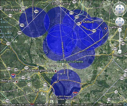
So afterwards, I found a mapping tool, and started mapping 3 mile retail trade areas from a handful of supermarkets that serve Brightwood, based on the comment reprinted above: Safeway in Petworth, Safeway at Piney Branch Road, Safeway in SW DC, Safeway in Chevy Chase, the Yes Grocery on Georgia Ave. NW, the PanAm Market at Michigan and Eastern Avenues, the Giant Supermarket on the DC-Maryland border at Eastern Avenue and Riggs Road in Prince George's County. But since so much of the city was covered just with these stores, I decided to start over.
I changed the radius to 1.5 miles from the store location. This is what the map looks like. It doesn't the proposed Safeway location on Riggs Road NE or the proposed Walmart on Georgia Avenue NW or New York Avenue NE. It doesn't include the PanAm store on 14th Street NW, the Magruders on Connecticut Ave. NW [which has great produce prices] or independent supermarkets in Mt. Pleasant, nor Florida Market. A lot of stores aren't listed. Just the main stores indicated above, plus that outlier store, the Safeway in SW DC, that is located within one mile of the proposed Whole Foods in SE DC.
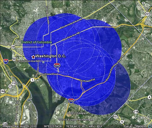
The map I did for Capitol Hill includes the Safeways at SW DC, City Vista in NW, on Kentucky Ave. SE, and at Hechinger Mall, the Harris Teeters at Potomac Avenue and New York Avenue Metros, the Yes Grocery on the 600 block of Pennsylvania Ave. SE (but not the one further SE), and Eastern Market.
What's not on the map: it doesn't include the Capitol Hill Supermarket at Massachusetts Ave. and 3rd St. NE or the proposed Aldi Supermarket by Hechinger Mall, the proposed Giant Supermarket on H Street NE, nor the proposed Walmart on New Jersey Avenue NW. It doesn't include the Giant Supermarket on Brentwood Road NE, nor Florida Market. Nor does it include the Whole Foods supermarket going into the GWU development on Washington Circle or the Trader Joes.)

If I would have had more sophisticated cartographic tools, I would have used at least four different colors for the mapped areas, differentiating between: (1) the newest and larger stores; (2) older mainline stores; (3) smaller ethnic and natural foods stores and public markets; (4) proposed store locations.
Obviously, a big issue for people is the newness of the store, and the perceived prestigiousness of the store brand (or banner as it is referred to in the trade). A Whole Foods or a Harris Teeter is ranked more highly in people's minds than Safeway or Giant, even though the high grade Safeway stores are reasonably competitive with Whole Foods and Harris Teeter (and cheaper), EXCEPT:
The big difference between Safeway/Giant and Whole Foods/Harris Teeter is the latter's focus on providing a wide array of prepared foods (although to my palate, the items at the 1st Street NE store are wanting compared to some of the other locations).
That still is the main difference between Safeway/Giant and Harris Teeter. (Giant still has not upgraded its store interiors comparable to the Safeway "Lifestyle" remodeling effort. This puts them further behind compared to their competitors, although it is possible that the new store on H Street NE and the remodeled stores in Cleveland Park and in Shaw will be upgraded. That wasn't the case for the Columbia Heights store.)
The difference between these companies and Whole Foods Market has to do with the perception of healthfulness and ethical consumer behavior as represented by the company and its product mix and brand promise.
------
Anyway, getting back to the maps, and the question posed to me in the previous entry, I'd be hard pressed to support tax abatements for supermarkets in areas already well-served by extant companies.
Note that this map of Capitol Hill and the area served by 1.5 mile RTAs, the only difference from the map above is the addition of the Yes Market at 2323 Pennsylvania Ave. SE
P.S. to people not from DC, and what appear to be areas that are not served, actually I didn't map more than one dozen locations of Safeway, Giant, and Whole Foods stores in DC, a Harris-Teeter in Adams-Morgan, some Yes Markets, etc. And I didn't include most stores on the Maryland side of the DC border that partly serve DC (such as the Whole Foods and Giant Supermarkets in Friendship Heights Maryland, the Giant, Whole Foods, and Safeway in Silver Spring, Maryland, the Takoma Park-Silver Spring Co-ops, etc.).
Labels: commercial district revitalization, economic development, supermarkets-groceries, tax incentives
posted by Richard Layman @ 4:25 PM&Permanent Link
![]()
![]()


1 Comments:
Much obliged to you for giving such essential data, and a debt of gratitude is for sharing this issue.
Post a Comment
<< Home