Union Station Master Plan, Washington DC
(Don't ever buy HP laptops... by brushing against the wrong keys, I've deleted this entry two separate times. Very aggravating.)
 Proposed new underground concourse for Washington's Union Station.
Yesterday's release of the Amtrak Master Plan for Washington's Union Station, concomitantly with presentation documents by Akridge Companies for their companion development of Burnham Place above the Union Station railyard, on a platform to be constructed as part of expansion plans for Union Station, raises a number of interesting issues, each of which deserves a separate blog entry.
Because each will take a couple hours to write, I'll be turning them out over the next few days. Here are the issues:
1. The Amtrak Union Station Master Plan as an element of general planning for the Northeast Corridor, and its being one of 3 maybe 4 BHAPs (not BHAGs, or big hairy a**ed goals, but big hairy a**ed projects) total, including in Baltimore, New York City, between DC and Richmond (although not the responsibility of Amtrak), plus planning for High Speed Rail.
2. The Amtrak Union Station Master Plan/Northeast Corridor Infrastructure Master Plan/Amtrak Vision for the Northeast Corridor, 2012 Update Report should be seen as a siren for action for regional transportation planning authorities and railroad passenger service organizations (MARC and VRE in particular) to create an equally visionary joint plan to scale up passenger railroad services in the region, even to the point of merger.
Especially in terms of proposals to underground railroad tracks along what would be Maryland Avenue SW (part of the Maryland Avenue SW Plan), how this impacts the Long Railroad Bridge, owned by CSX, but used by Amtrak and VRE as well to get between DC, Virginia, and other points southward, enhanced railroad services in Northern Virginia, and Virginia, and MARC's dreams to be able to run trains past Union Station into Northern Virginia.

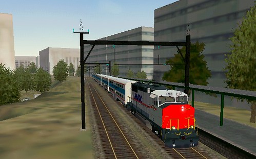
Simulation, MARC train in L'Enfant Plaza area, Washington, DC, by Steve Dunham.
3. The role of Union Station as a key civic asset and element of the city's visionary planning history as it relates to the City Beautiful movement and the McMillan Senate Parks Commission Plan of 1902. And how for the first time in a long time, this kind of BHAP sets a new stage and vision for land use planning in DC.
4. The Akridge Companies plans for Burnham Place, which requires the construction of a difficult and expensive platform over the portion of the Union Station railyard that is particularly wide, is quite interesting in what it communicates about strong real estate markets with a decreasing inventory of developable land--that really hard projects will be done when even at great infrastructure expense, they are profitable.
The project will be big: 1.5 million square feet of office space, more than 1,300 residential units, 500 hotel rooms, and 100,000 square feet of retail space. And of yesterday's presenters, more than 10, I thought that Chairman of the company John Akridge was one of the best speakers (along with former Mayor of DC Anthony Williams, and Dep. Secretary of Transportation John Porcari).

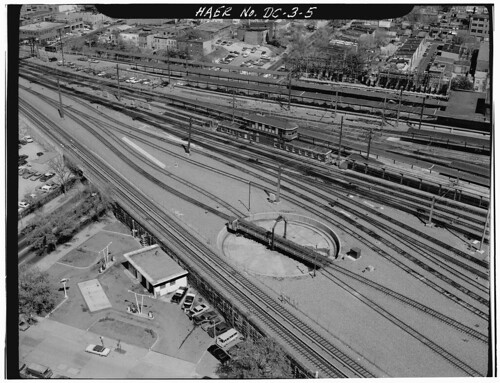
Union Station railyard. Photo: Historic American Engineering Service, 1970s. In the upper left of the photo, the western side of Square 749 can be seen, along 2nd Street NE, and is marked by 3 story light industrial buildings likely constructed in the late 1800s or very early 1900s, even before the construction of Union Station (1907).
Other similar projects that are moving forward include Atlantic Yards in Brooklyn and Hudson Yards in Manhattan. Redevelopment projects that don't require difficult and expensive platforms include Potomac Yards in Arlington/Alexandria, Pearl District in Portland, and proposals for Sacramento.
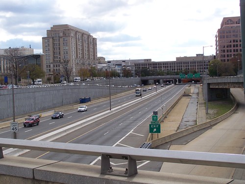
5. Along with the proposed redevelopment above I-395 between Massachusetts Avenue and E Street NW, Burnham Place gives us a reason to rethink other similar kinds of decking opportunities elsewhere in the city, but in a more systematic way than we are today.

Area of the air rights project, I-395, Downtown DC.
DC's Southeast-Southwest Freeway offers that kind of opportunity.
Such projects are expensive, but if the trench is wide enough, enough land will be recovered to make it financially worthwhile. And DC, as long as it doesn't develop upwards, by puncturing the height limit, is going to have to continue to expand commercial development outward from the core of the "central" business district.
Most cities, despite examples here and there, don't have a strong enough real estate development market for new construction to be able to pull this off.
Labels: land use planning, real estate development, transportation infrastructure, transportation planning, urban design/placemaking


0 Comments:
Post a Comment
<< Home