More discussion of the height limit #2: Without adding high capacity transit service, there should be no increase in allowable heights
The point of planning is supposed to be the mitigation/warding off of potential problems by anticipating and addressing the various impacts of plan elements.
Thinking about the height limit discussion in greater detail, the discussion hasn't gone beyond the most basic economic arguments in favor and the historic and viewshed arguments against.
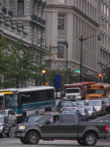
The city's subway system will reach capacity in the next decade based on current allowable build out. And while it's true that the proposed streetcar system will improve intra-city mobility, it won't significantly add to the ability to move large numbers of people into (and out of) the city quickly and efficiently.
Doubling allowable building height, at least in the Central Business District and adding 100,000 jobs to the city as called for in the city's new Five-Year Economic Development Strategy can't be accommodated by the current infrastructure--roads for cars and subway lines underground for transit--and by plans to increase bus service and add streetcar service. T
The transportation system will grind to a halt and "congestion" will reign (except for pedestrians and bicyclists).
Point number two in an expanded discussion of the height limit is that permission to build taller buildings should be tied to an expansion of high capacity transit service, especially to those parts of the city where more intense density is being considered, and in the Central Business District specifically.
To repeat, Changing the Height Limit should occur only if linked to commitments to expand the high capacity fixed rail transit system.
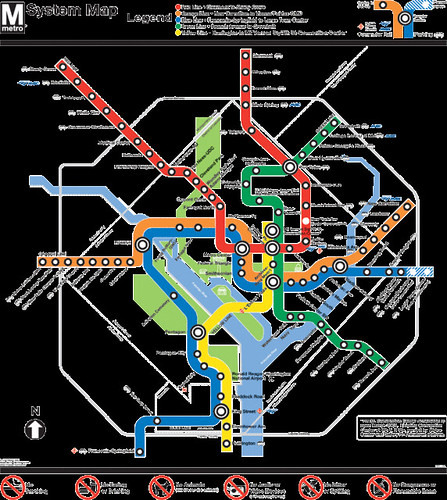
Roughly half of the subway system's 86 stations serve the city. There are 40 stations in the city and two on the border (Friendship Heights has one station entrance in the city and one in Maryland; Capitol Heights is in Maryland, on the border of the city). Depending on your definition, 31-32 of the stations serve the core of the city, about a 20 square mile area that comprises 1/3 of the city.
Triggered by the height limit discussion and in advance of DC's advancing on the creation of a new transportation vision plan next year, DC needs to lay out a new way forward for transportation planning, with tight linkages between land use intensity and transportation infrastructure (indirectly this is called for by the city's sustainability plan, which sets a goal of 75% of all trips being by walking, biking, transit, and rideshare, although substantive additions to transit infrastructure are not called for in that plan), including:
1. Linking development approvals to transit capacity and expansions in transit infrastructure. For example, the Potomac Yards development serves an area (the Rte. 1 corridor) that is already significantly congested, being as it abuts Crystal City, one of Northern Virginia's major commercial centers.
Arlington and Alexandria's plan for Potomac Yards conditions development approvals on simultaneous expansion of transit service and congestion reduction. Otherwise, construction plans cannot move forward because permission to proceed is not granted.
To help coordinate improvements, a transportation management association (FAST Potomac Yard) was created to manage transportation demand and reduce congestion. Longer term, to serve the development, plans are moving forward to build an infill subway station ("Alexandria seeking funds to study Potomac Yard Metro stop " from the Examiner), and to add streetcar service ("Arlington and Alexandria Agree to Move in Different Directions on Corridor: Street car to move forward in Arlington; its future is uncertain in Alexandria" from the Connection Newspapers). Expanded bus service and the installation of a transitway (bus now, streetcar later) has already occurred.
By contrast, DC does not link transit capacity expansion to development approval processes.
Plans for more intense development at McMillan Reservoir, the Armed Forces Retirement Home, Reservation 13, Poplar Point, the St. Elzabeths East and West campuses, Walter Reed, not to mention the discussion to allow taller buildings, either Downtown or elsewhere in the city, have not triggered discussions on the necessity of adding transit infrastructure to serve the increase in trip demand that will be generated by these developments.
2. Requiring transportation demand management planning in the city's major activity centers and implementing transportation management districts to coordinate mobility throughput in key activity centers. In part this can be accomplished by adding this responsibility to business improvement districts in a formal way.
There are two main ways to do this. The local government may do it, for example Montgomery County has five TMDs. (The Friendship Heights TMD includes DC representation.) Or public-private partnerships come together to create a "transportation management association." The FAST organization in Potomac Yards/Arlington-Alexandria is one such example. (The Association for Commuter Transportation is the trade group for these kinds of services.)
The business improvement districts serving the primary commercial activity centers are Capital Riverfront, Capitol Hill, Downtown, Georgetown, Golden Triangle, Mount Vernon Triangle, and NoMA. Friendship Heights and Van Ness don't have BIDs but would need to be set up as TMDs, although the Friendship Heights TMD could be a joint venture between Montgomery County and DC. Adams-Morgan BID needs a transportation management plan for night time. Maybe H Street does too. Those places aren't primarily commercial, but a TMD would be important, if only to coordinate investments in parking, transit, and other public space improvements.
3. Creating funding mechanisms to fund transportation improvements and transit capacity expansion ("Making bus service sexy and more equitable;" "More thoughts on transportation district funding").
Options include imposing a transit withholding tax ("Commuter/mobility tax discussion"), a general transportation tax on commercial property (Alexandria attempted to do something like this, although they didn't go through with it, see "No commercial add-on tax in Alexandria" from the Washington Business Journal) and the creation of geographically defined transit improvement financing districts of various sorts (see the discussion in "Five transportation funding solutions" from CommonWealth Magazine). Alexandria has created such a district to partially fund an infill subway station to serve Potomac Yards and Fairfax County just created such a district for Tysons ("Fairfax County Endorses Tax Hike for Tysons Transportation" from the McLean Patch). DC created a tax increment financing district to pay for 1/3 of the cost of building the NoMA subway station.
In Portland, Oregon, the Interstate/Yellow Line MAX light rail line was funded through the creation of an Urban Renewal District and the sales of bonds against anticipated future property tax revenues from increased development as a result of the line. And somewhat controversially, DC has suggested creating an "add-on" property tax like that proposed in Alexandria to fund streetcar expansion (DC Streetcar Land Use Study, DC Office of Planning), for a certain distance from the proposed lines.
4. Committing to specific transit capacity expansions including:
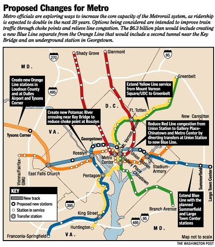
(a.) the so-called separated blue line heavy rail subway line, which will address coming capacity constraints Downtown by adding new capacity and also redundancy (a good thing for a variety of reasons). This line would add service to Georgetown, an additional crossing of the Potomac River, stations between Georgetown and Union Station, and stations past Union Station in the H Street-Benning Road corridor, including around Oklahoma Avenue/the northern edge of the RFK Parking lots and the former PEPCO electric power plant, which is going to be redeveloped. The line could be conceptualized as an extension of the Silver Line as shown in the second image below.
(b.) additional infill subway stations on the Green Line to expand service options in Anacostia/East of the River to development sites there (Poplar Point, St. Elizabeths West Campus, St. Elizabeths East Campus);
(c.) an infill station on the Yellow Line to serve the Jefferson Memorial (this would serve tourism and congestion reduction in the National Mall/14th Street corridor more than proposed density increases elsewhere in the city);
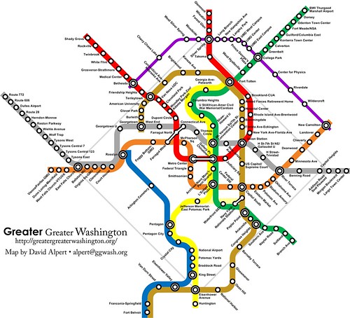
(d.) discussion of other expansion ideas including a separated yellow line ("Imagine a separate Yellow Line" from Greater Greater Washington) and/or a brown line (image of first concept, second concept below)
(e.) streetcar service on Georgia Avenue (to serve in part development at Walter Reed) and the cross-town line which could serve McMillan Reservoir, the Washington Hospital Center, the Armed Forces Retirement Home campus, and the proposed CUA Research Park (not mentioned in the "Five-Year Economic Development Strategy" document) (see "Will streetcars really return to the Capital City")
_____
While Charlie will complain about my deification of Arlington County, there is no question that planning is better there, because the County Growth Plan and the Transportation Plan are intertwined and the transportation plan is focused specifically on mitigating the transportation impacts of economic growth by reducing congestion through more efficient utilization of the mobility system, and on reducing motor vehicle traffic specifically.
Goal 2 – Move More People Without More Traffic. (p. 3; Master Transportation Plan Goals & Strategies)
Provide more travel choices and reduce the relative proportion of single‐occupant‐vehicle (SOV) travel through Transportation Demand Management (TDM), telecommuting, and travel shifts to other modes including transit, carpooling, walking, and bicycling.
Note by contrast that the recently released and now touted "Five-Year Economic Development Strategy" barely mentions transit (seven mentions, less than 100 words in total, and 3 of the 7 mentions merely repeat previous discussion), apparently not considering transit service and mobility as perhaps the most fundamental element of the city's continued economic success:
• transit isn't listed as one of the city's "unique assets" (p. 10) (although "top-notch public transit" is listed on p. 74 as one of the city's advantages that can support retail) even though the subway system is the #1 element that has fueled the city's resurgence.
• transit expansion isn't identified as a necessary component of the strategies to "Grow & Diversify DC’s Economy" (p. 11) (although transit improvements on "Great Streets" corridors is discussed on p. 77).
• transit and transit expansion isn't considered to be a necessary and key element of the economic plan to realize "bold visions for a transformed DC" (p. 12).
• the strategy fails to address the impact on the mobility system of adding 100,000 new jobs to the city in terms of moving an additional 100,000 people to and from those jobs (section on "Insights and Findings, p. 16-20)--it's like constructing a 25 million square foot building without any places to park and limited transit access.
The plan mostly considers transit in the context of expanding the city's retail offer:
• Dense, walkable neighborhoods and mixed-use development centered on mass transit are increasingly important for retail growth. (p. 18).
• DC has tremendous assets to leverage, with its neighborhoods, transit options and vibrant nightlife providing natural magnets for the young professionals who are the lifeblood of technology companies (p. 25).
• Great Streets initiative: ... More than $200 million is being invested in mixed-use development projects, storefront improvements, transportation upgrades, streetscape and transit improvements in these nine corridors (p. 77).
To support more economic activity in the city and all types of exchange (see the discussion about exchange in Reclaiming our cities and towns: better living through less traffic by David Engwicht) there has to be an overt recognition that "more transit" is required to accomplish this, although a goodly amount of mobility demand can be redirected to more optimal means by using existing mobility infrastructure more efficiently, by shifting trips to walking and biking, and to existing and expanded surface transit, and even the implementation of intelligent transportation systems.
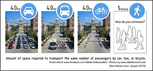
Sustainable transportation (walking, biking, transit, living closer to work, etc.) is far more efficient than relying on the automobile to serve large numbers of trips in short periods of time going to activity centers. While there are many illustrations of this point, I like this one from the Urban Ambassadors of Des Moines.
Southbound on 14th Street NW during evening rush hour.
Eastbound on Rhode Island Avenue NE during evening rush hour.

Labels: agglomeration economies, proffers-community benefits, real estate development, transit oriented development, transportation planning, urban design/placemaking, urban revitalization, zoning
posted by Richard Layman @ 7:08 AM&Permanent Link
![]()
![]()


6 Comments:
You're right, I am going to bash you on the Arlington-love.
(although maybe the mistake was to do so on GGW rather than here)
In terms of a plan, yes, Arlington at least has one. And I don't think the power grab by county board members has moved into the transport realm. Many people disagree w/r/t the Pike streetcar, but the underlying logic makes sense.
That being said, I've seen how much worse traffic has gotten in 15 years. The failure of TDM in arlington is assuming too many work trips and not enough leisure trips. For instance, Wilson/Clarendon doesn't get jammed up in the AM, but can turn into parking lots in the evening.
I'd very much go with you that the real preference is walking, with biking a very distant second, but that mode requires very spread out workplaces. IF we had a traditional downtown, the 30 minute walk radius would be limited .
(in fact, it is interesting that the new city model seem to move away from a CBD all together. Miami, Vancouver, Toronto, etc....)
Also, the basic problem with the height limit discussion is it is blogger driven; i.e. a overworked philosophy major trying to impress some libertarian girl that he isn't oppsed to every regulation. IN terms of city functions, I recognize the tax argument but we are no where near a point where the height limit is a real issue.
I will concede that I don't know Arlington as well as you do. And that I spend more time there during daytime hours than at night.
I can see how it would be f*ed up, remembering being there once at night in Clarendon in 2002...
That calls for different strategies which are probably out of the comfort zone of the TDM operation.
I did write about those kinds of issues wrt Adams-Morgan starting in 2005 though, and for many years advocated for the creation of a transportation management district on H St. for similar reasons.
The UK events I referenced in my writings were more about managing the security aspects of nighttime drinking and revelry. I extended that to transportation. BUt I was still impressed how Members of Parliament did a walk through of Westminster starting at 11pm on a Friday night, rather than a Tuesday morning...
note that with night time and weekend trips I argue that TMDs should provide coordination for package delivery services and intra-neighborhood transit--getting people from their home to transit lines and stations. (In my frameworks I call this "tertiary" transit service. Like the circulators outside of Downtown in DC, services in Tempe, Scottsdale, and Mesa--Tempe's is called Orbit, etc.)
People wouldn't have to drive to the supermarket (well, if it's not Costco) if they knew that they could get a ride home. And one van delivering 4-6 people and their purchases is a lot more efficient than having 4-6 more trips each way.
Similarly, a problem with biking (not walking) is getting to places in groups. Intra-neighborhood transit could facilitate this, and reduce leisure-related automobile trips.
Again, we're talking about theory. It's how it works in my head. I have yet to see it fully in practice outside of those communities around Phoenix (and I don't think package delivery is coordinated there).
Well, I can see why you like Arlington as a model, because of the slightly higher value put on the planning process. However, it is far from perfect.
In terms of the height limit, I can see the frustration with DC looking across the river to the ever-growing Rosslyn skyline. However, the reality of the real estate market is rents are a lot lower because people don't want to be so far away*. And despite the work of the BID, it is NOT a premium location and will not be for a long time.
The arlington TDM has been successful with walking, much less so with biking, and in terms of driving things are worse than they pretend.
* CEB was a major win for Arlington over DC. KPMG claims something like 5000+ employees but there is no way they are all in one building. CEB did want one space. David Bradley also has his own ideas on real estate -- for instance he owned the Watergate buildings where CEB/Advisory board used to be located (and where the Atlantic is now HQed)
i think 'expanding walk/bike' capacity should be part of the conversation in a serious way.
This is a nice post.
This post shares information about high capacity transit service.
High-capacity transit-frameworks that convey an enormous number of individuals is a significant part of many significant metropolitan territories. Alongside different advantages related to open transportation, high-capacity transit offers one answer for an issue that diseases numerous Las Vegans: traffic blockage.
"cheap Medicine online"
Post a Comment
<< Home