I dream of a cycletrack across Rock Creek Park on Military Road NW
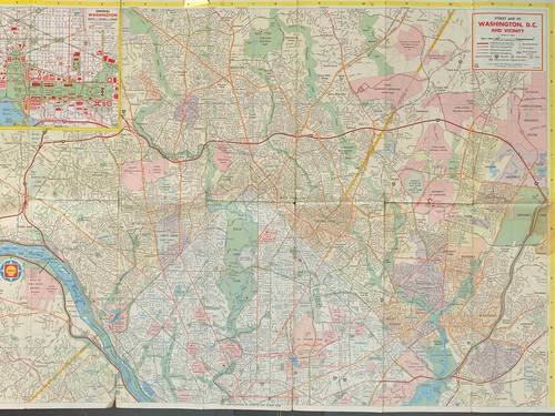 North of Michigan Avenue there isn't really a good east-west road crossing the entire northern part of the city, other than the combination of Riggs Road-Missouri Avenue-Military Road.
Left: 1967 Shell Map of Washington DC. (It shows proposed routes for intra-city freeways too.)
Using Military Road is the the only way to get from my part of the city to Friendship Heights or Chevy Chase, but it's a terrible place to cycle because the road is narrow and/or the cars drive really really fast.
While it would be expensive to create, there is space on the park sides of the street to incorporate a cycletrack.
Meanwhile, those cyclists brave enough to ride here do so like this.
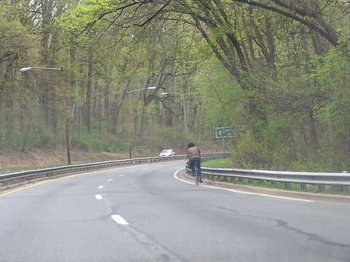
It might look pretty but it's neither comfortable nor safe.
(Speaking of being the "odd man out," when people tell me how great it is to bike in DC because we have more than 50 miles of bike lanes and cycletracks, I counter with the point that we have close to 2,000 miles of traditional roads.)
Labels: bicycling, parks and trails, parks planning, transportation infrastructure, transportation planning, urban design/placemaking
posted by Richard Layman @ 11:59 AM&Permanent Link
![]()
![]()


9 Comments:
every major road and street in Berlin, Cologne and Munich have separated auto protected bikeways- we have so few that it just aint funny- we have a really long ways to go here before we can match the north Euro cycling experience..
Yes yes yes! That plus safer pedestrian access to the bus stops on Military down in the park would make for much better crosstown non-car travel options. As a woman alone, I hesitate to walk down from 16th to those isolated bus shelters between the access road the main roadway - scary because of isolation when it's busy, and scary because of converging traffic when it is. What do you think are the chances NPS would actually do anything useful to facilitate transit and bike access within RCP?
In theory, NPS is doing a transportation plan for all the parks in this district. It remains to be seen how committed they will be to doing this kind of infrastructure for three primary reasons:
1. They don't see their role as facilitating transportation that is only tangentially related to the park/their parks, even if it is exercise related, like biking. (Note that this is a problem with most every parks entity, not just NPS. E.g., it's a problem with the Montgomery County Parks Dept. But not every one. The Baltimore City Parks Dept. is pretty good with trails issues. And the Balt. County Parks Dept. was interested, although they weren't leading the planning efforts for trails in the county.)
2. They have so many financial needs, and so these kinds of improvements take a back seat to more "park-y" improvements.
3. DC doesn't do parks master planning or transportation master planning well enough that makes recommendations for the parks.
I think even though the parks are federal, if DC doesn't represent DC resident interests in the planning process, then no one will.
Since most of the park land is federal, if DC wants this kind of infrastructure in those places, and face it, like your bus examples, these are improvements that mostly serve residents, DC will have to pay for it.
I think that's a legitimate thing to spend DC money on. I'm not sure that others will agree though.
Thanks for bringing this up. A cycle track on that stretch is sorely needed. I biked across the park on Military Rd the other day, and it is absolutely terrifying, but there is no real way around it.
There is a bike path parallel to Military (north side) between Rock Creek and Oregon. It is hilly and not in great shape, but its an option. East of Rock Creek one can ride on Joyce Road to Missouri Ave, both run parallel to Military on he south side. you cross military under the bridge over Rock Creek. It is not efficient, but its better than Military. This route probably makes even more sense if you are jogging across the park.
A cycle Track would be great from Georgia to Utah, but I don't see it happening. Plans are for that stretch to have a street car, which puts space at even more of a premium.
Maybe the Park could be convinced to trade the existing path through the woods for a flatter new path on the south side of Military?
I should have noted the path between Oregon and Rock Creek is only maybe 30 or 40 years north of Military road in the woods.
I've seen that path -- when there isn't leaf and brush cover -- but have no idea on how to get to it.
And I only noticed the path within the past couple of months... another example of the need for regional bikeway signage.
The path only goes to the Joyce Rd/Beach Drive intersection, after that you are dumped back onto roads with no sidewalks or shoulders or sightlines. Also if you are coming from the east there is no easy way to get down there except to ride against traffic on Missouri Ave to Joyce Rd.
Hilly? Funny, I make fun of people who run on that path as I prefer the slighly harder one by the fort. IN any case, you are climbing out of valley and it isn't fun going up.
Richard, turn on Oregon and follow the bike path.
Agreed on the east side it is more of a problem.
Post a Comment
<< Home